NTRAC Final Study - Nebraska Department of Roads - State of ...
NTRAC Final Study - Nebraska Department of Roads - State of ...
NTRAC Final Study - Nebraska Department of Roads - State of ...

Create successful ePaper yourself
Turn your PDF publications into a flip-book with our unique Google optimized e-Paper software.
EXISTING CONDITIONS<br />
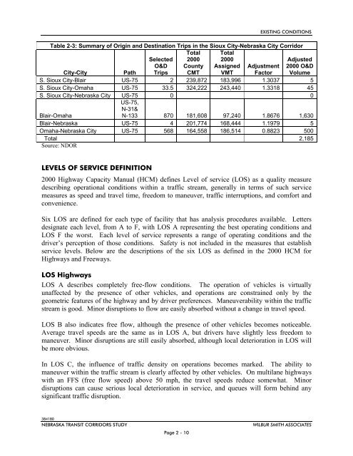
Table 2-3: Summary <strong>of</strong> Origin and Destination Trips in the Sioux City-<strong>Nebraska</strong> City Corridor<br />
City-City<br />
Path<br />
Selected<br />
O&D<br />
Trips<br />
Total<br />
2000<br />
County<br />
CMT<br />
Total<br />
2000<br />
Assigned<br />
VMT<br />
Adjustment<br />
Factor<br />
Adjusted<br />
2000 O&D<br />
Volume<br />
S. Sioux City-Blair US-75 2 239,872 183,996 1.3037 5<br />
S. Sioux City-Omaha US-75 33.5 324,222 243,440 1.3318 45<br />
S. Sioux City-<strong>Nebraska</strong> City US-75 0 0<br />
Blair-Omaha<br />
US-75,<br />
N-31&<br />
N-133 870 181,608 97,240 1.8676 1,630<br />
Blair-<strong>Nebraska</strong> US-75 4 201,774 168,444 1.1979 5<br />
Omaha-<strong>Nebraska</strong> City US-75 568 164,558 186,514 0.8823 500<br />
Total 2,185<br />
Source: NDOR<br />
LEVELS OF SERVICE DEFINITION<br />
2000 Highway Capacity Manual (HCM) defines Level <strong>of</strong> service (LOS) as a quality measure<br />
describing operational conditions within a traffic stream, generally in terms <strong>of</strong> such service<br />
measures as speed and travel time, freedom to maneuver, traffic interruptions, and comfort and<br />
convenience.<br />
Six LOS are defined for each type <strong>of</strong> facility that has analysis procedures available. Letters<br />
designate each level, from A to F, with LOS A representing the best operating conditions and<br />
LOS F the worst. Each level <strong>of</strong> service represents a range <strong>of</strong> operating conditions and the<br />
driver’s perception <strong>of</strong> those conditions. Safety is not included in the measures that establish<br />
service levels. Below are the descriptions <strong>of</strong> the six LOS as defined in the 2000 HCM for<br />
Highways and Freeways.<br />
LOS Highways<br />
LOS A describes completely free-flow conditions. The operation <strong>of</strong> vehicles is virtually<br />
unaffected by the presence <strong>of</strong> other vehicles, and operations are constrained only by the<br />
geometric features <strong>of</strong> the highway and by driver preferences. Maneuverability within the traffic<br />
stream is good. Minor disruptions to flow are easily absorbed without a change in travel speed.<br />
LOS B also indicates free flow, although the presence <strong>of</strong> other vehicles becomes noticeable.<br />
Average travel speeds are the same as in LOS A, but drivers have slightly less freedom to<br />
maneuver. Minor disruptions are still easily absorbed, although local deterioration in LOS will<br />
be more obvious.<br />
In LOS C, the influence <strong>of</strong> traffic density on operations becomes marked. The ability to<br />
maneuver within the traffic stream is clearly affected by other vehicles. On multilane highways<br />
with an FFS (free flow speed) above 50 mph, the travel speeds reduce somewhat. Minor<br />
disruptions can cause serious local deterioration in service, and queues will form behind any<br />
significant traffic disruption.<br />
384180<br />
NEBRASKA TRANSIT CORRIDORS STUDY<br />
Page 2 - 10<br />
WILBUR SMITH ASSOCIATES