

Low (web) Quality - BALTEX
Low (web) Quality - BALTEX
Low (web) Quality - BALTEX

You also want an ePaper? Increase the reach of your titles
YUMPU automatically turns print PDFs into web optimized ePapers that Google loves.
283<br />
Streamflow in the upper Mississippi river basin as simulated by SWAT<br />
driven by 20C results of NARCCAP regional climate models<br />
E. S. Takle, M. Jha, E. Lu, R. W. Arritt, W. J. Gutowski, Jr., and the NARCCAP Team<br />
Iowa State University, Ames, IA 50011 USA, gstakle@iatate.edu<br />
1. Introduction<br />
Major hydrological quantities in the Upper Mississippi River<br />
Basin (UMRB) in the last two decades of the 20C are<br />
evaluated with the Soil and Water Assessment Tool<br />
(SWAT) in comparison with observed streamflow. Inputs to<br />
SWAT are provided by the daily meteorological quantities<br />
from observed at weather stations in the basin and from<br />
daily meteorological conditions simulated by a subset of<br />
regional climate models reporting to the archive of the North<br />
American Regional Climate Change Assessment Program<br />
(NARCCAP, 2009) driven by reanalysis boundary<br />
conditions. Results show that regional models correctly<br />
simulate the seasonal cycle of precipitation, temperature,<br />
and streamflow within the basin. Regional models also<br />
capture interannual extremes represented by the flood of<br />
1993 and the dry conditions of 2000.<br />
2. Soil and Water Assessment Tool<br />
The SWAT (Arnold and Fohrer, 2005) is a physically based,<br />
continuous time, long-term, watershed scale hydrology and<br />
water quality model. SWAT version 2005 was used for this<br />
analysis. Meteorological input to SWAT includes daily<br />
values of maximum and minimum temperature, total<br />
precipitation, mean wind speed, total solar radiation, and<br />
mean relative humidity. The hydrologic cycle as simulated<br />
by SWAT at the HRU level is based on the balance of<br />
precipitation, surface runoff, percolation, evapotranspiration,<br />
and soil water storage. SWAT takes total daily precipitation<br />
from models or observations and classifies it as rain or snow<br />
using the average daily temperature. When climate model<br />
output is provided, SWAT uses only total liquid<br />
precipitation and does its own partitioning to rain or snow.<br />
Snow cover is allowed to be non-uniform cover due to<br />
shading, drifting, topography and land cover and is allowed<br />
to decline non-linearly based on an areal depletion curve.<br />
Snowmelt, a critical factor in partitioning between runoff<br />
and baseflow, is controlled by the air and snow pack<br />
temperature, the melting rate, and the areal coverage of<br />
snow. On days when the maximum temperature exceeds<br />
0ºC, snow melts according to a linear relationship of the<br />
difference between the average snow pack maximum<br />
temperature and the base or threshold temperature for<br />
snowmelt. The melt factor varies seasonally, and melted<br />
snow is treated the same as rainfall for estimating runoff and<br />
percolation. Further details can also be found in the SWAT<br />
User's manual (Neitsch et al., 2002).<br />
3. Regional Climate Models<br />
A preliminary analysis is presented of three regional climate<br />
models reporting to the NARCCAP archive: MM5I run at<br />
Iowa State University, RCM3 run by the University of<br />
California – Santa Cruz, and the WRFP model run at the<br />
Pacific Northwest National Laboratory. The 20C<br />
simulations of NARCCAP consist of simulations over North<br />
America for 1980-2004 driven by NCEP reanalysis data at<br />
lateral boundaries.<br />
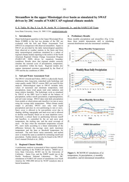
4. Preliminary Results<br />
Mean monthly precipitation and streamflow (Fig 1) for<br />
these three models demonstrate skill in simulating<br />
seasonal distributions and also interannual variability.<br />
a)<br />
b)<br />
c)<br />
d)<br />
Figure 1. RCM/SWAT simulations of a)<br />
temperature, b) precipitation, c) monthly<br />
streamflow, and d) interannual streamflow.


