332K¤IVÁNEK – KUNA – KOREN¯: Hradi‰tû Ple‰ivec …Největším problémem průzkumu byl velký rozsah areálu. Po novém zaměření lokality představujeplocha hradiště 55,9 ha (z toho 16,5 ha tvoří vnitřní hradiště či akropole). Většina depotů ovšembyla dosud nalezena vně opevnění, na úbočích vrchu, a tudíž plocha s potenciálním výskytech dalšíchnálezů činí několik set hektarů. Od počátku bylo tedy zřejmé, že s dostupnými kapacitami nelze prozkoumatcelý areál, nýbrž pouze jeho část či vzorek. Po vyhodnocení (jakkoli nejasných) informacío místech dřívějších nálezů bronzových předmětů (Kytlicová 1963; Radoměrský 1955; Korený –Novák 2004; Frána 2004) a nově nalezených depotech (Waldhauser 2001; Korený – Slabina – Waldhauser2000) jsme se rozhodli věnovat přednostní pozornost (i) prostoru podél valů, (ii) vybranýmmístům ve vnitřním hradišti a (iii) prostoru nad hájovnou Bezdědičky, kam byly lokalizovány některéz nových nálezů. Celkem byla detektorovým průzkumem pokryta plocha ca 35,7 ha.Výsledky detektorového průzkumuZ hlediska nových nálezů pravěkých kovových artefaktů nebyly celkové výsledky detektorovéhoprůzkumu uspokojivé. Na ploše průzkumu nebyly nalezeny žádné pravěké kovové artefakty. Pomineme-linález dvou malých zlomků mosazného drátku potenciálně středověkého stáří na jižním úbočívně valu, jediným kovovým nálezem většího stáří byla skupina malých bronzových slitků z prostorunové mýtiny pod Starými vraty. Místo nálezu leží vně hradiště, ca 130 m jižně od brány (obr. 8),přičemž první slitky zde byly detektorem nalezeny na ploše několika čtverečních metrů, v hloubce10–20 cm.V místě nálezu byla položena sonda o rozměrech 5 x 2 m. Kromě identifikace několika dalších,ještě menších zlomků bronzoviny a tenké přepálené vrstvy (související ovšem pravděpodobně s recentnímspalováním větví při těžbě dřeva) však nebyly žádné archeologické situace zjištěny a v hloubce20 cm byl odkryv ukončen na zvětralém skalním podloží. Za zmínku také stojí, že po ukončenémověřovacím výzkumu toto místo neušlo pozornosti osob s detektory, nejpravděpodobněji místníchči s místní situací dobře obeznámených a sledujících provoz na hradišti.Celkem bylo zjištěno 16 slitků (obr. 9). Z kombinovaných výsledků rentgenfluorescenční analýzy(RFA; tab. 1) a instrumentální neutronové aktivační analýzy (INAA; tab. 2) vyplývá, že slitky s velkoupravděpodobností indikují místo pravěké metalurgické činnosti, a to (podle prvkového složení)pravděpodobně z mladší doby bronzové. Dva zlomky jsou z téměř čisté surové mědi, ostatní zlomkyautuhlé kapky z cínového bronzu bez jakýchkoli dalších výrazných příměsí. Z hlediska technologickéhopředstavuje dle autorů expertíz (Frána – Fikrle 2004; měření INAA) větší část zkoumanýchvzorků (12 ks) hotový cínový bronz, přičemž množství cínu ve slitině dosahuje hodnoty 6–9 % (třikrát)a 10–14 % (sedmkrát); v jednom případě takřka 18 %. Tyto hodnoty, ale i zastoupení dalších prvků(např. Ag, As, Ni, Co, Sb), odpovídají hodnotám naměřeným v některých depotech mladší doby bronzovéz Plešivce (Rejkovice III a IV: Frána et al. 1997, 65, 163–164). Podle autorů analýz je protomožné, že jde o materiál stejného stáří, tj. z období knovízské kultury (k metalurgii v daném obdobínapř. Smejtek 1984; Slabina – Smejtek 2005). Jeden ze slitků (inv. č. 35644) se od ostatních odlišujevyšším obsahem zinku (1,8 %). Případ podobné hodnoty byl však mezi staršími nálezy z Plešivce jižjednou zjištěn (depot IX), a i když současnost předmětu není nesporná, lze ji jako výjimku připustit(Frána et al. 1997, 67).Všechny ostatní nálezy z detektorového průzkumu již můžeme dát do souvislostí s mnohemmladší historií lokality. Novověké, převážně železné artefakty (podkovy, hřeby, beztvaré zlomky, aletaké kovové spojky potrubí) byly nacházeny často a dokládají např. dřívější těžbu dřeva, komunikace,výrobu dřevěného uhlí nebo zaniklý vodovod k prostoru hájovny.Pokud bychom výsledky průzkumu měřili pouze množstvím získaných kovových nálezů, je třebakonstatovat, že nebyly velké; rizika nízké efektivity průzkumu jsme si ovšem byli vědomi od počátku.Do jisté míry může tento neúspěch vyvážit získaná zkušenost a poznání pravděpodobnýchpříčin malého množství získaných nálezů.Lze připustit, že jednou z příčin relativně malých výsledků detektorového průzkumu je nasazenírelativně malých kapacit vzhledem k rozsahu areálu a potenciální hustotě pravěkých kovových nálezů.Zhruba 40–50 dnů práce detektoru s dvoučlennou obsluhou představovalo hranici našich mož-
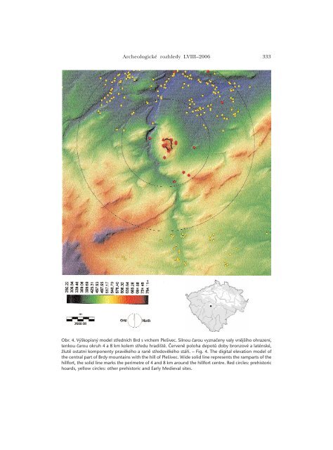
<strong>Archeologické</strong> <strong>rozhledy</strong> LVIII–<strong>2006</strong> 333Obr. 4. Výškopisný model středních Brd s vrchem Plešivec. Silnou čarou vyznačeny valy vnějšího ohrazení,tenkou čarou okruh 4 a 8 km kolem středu hradiště. Červeně poloha depotů doby bronzové a laténské,žlutě ostatní komponenty pravěkého a raně středověkého stáří. – Fig. 4. The digital elevation model ofthe central part of Brdy mountains with the hill of Plešivec. Wide solid line represents the ramparts of thehillfort, the solid line marks the perimetre of 4 and 8 km around the hillfort centre. Red circles: prehistorichoards, yellow circles: other prehistoric and Early Medieval sites.