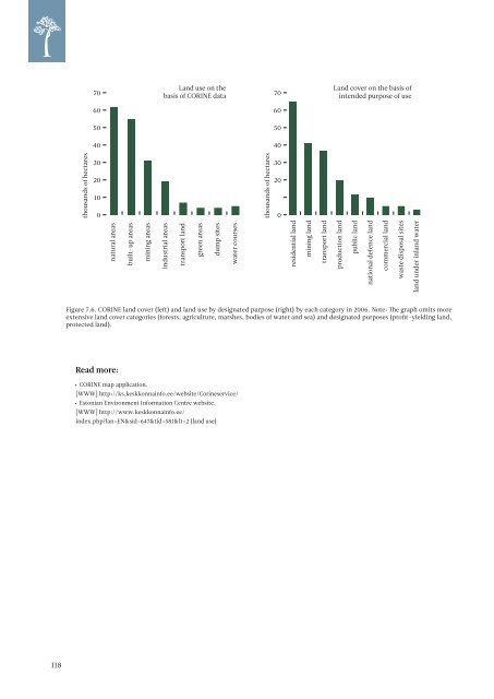
80 80 70 Land use on the basis of CORINE data 70 Land cover on the basis of intended purpose of use 60 60 50 50 40 40 thousands of hectares 30 20 10 0 thousands of hectares 30 20 0 natural areas built-up areas mining areas industrial areas transport land green areas dump sites water courses residential land mining land transport land production land public land national defence land commercial land waste disposal sites land under inland water Figure 7.6. CORINE land cover (left) and land use by designated purpose (right) by each category in 2006. Note: The graph omits more extensive land cover categories (forests, agriculture, marshes, bodies of water and sea) and designated purposes (profit-yielding land, protected land). Read more: • CORINE map application. [WWW] http://ks.keskkonnainfo.ee/website/Corineservice/ • Estonian Environment Information Centre website. [WWW] http://www.keskkonnainfo.ee/ index.php?lan=EN&sid=647&tid=581&l1=2 (land use) 10 118
7.3. Urban sprawl Suburban sprawl is when cities expand — residential areas spread from city centres to the suburbs and beyond, to the rural areas near the city, where land is cheaper. One reason for urban sprawl is the rapid rise in the standard of living. Sprawl is accompanied by changes in land use and dependence on transportation. The increase in automotive transportation is on one hand a precondition for sprawl, but on the other hand it is also the outcome, as families who have settled in new residential communities depend on city centres for jobs, schools, shops, and entertainment venues. Many negative impacts accompany sprawl both with regard to the natural environment and living environment (traffic jams, noise, air pollution). Tallinn and its near vicinity have a rapidly growing number of inhabitants and it is the area of Estonia that generates the greatest monetary turnover, which is why it is logical that housing construction pressure is much greater here than it is in the rest of Estonia (see also map 7.3). Housing construction, which was relatively modest in the 1990s (and fell short of the housing construction volumes in the Soviet period), saw rapid growth in the 2000s in the Tallinn areas and many areas that were previously reserved for other purposes were rezoned as residential areas. Primarily the areas adopted for residential purposes were seaside areas that were under Soviet border regime restrictions and former cropland. The internal structure of the new residential areas is different from the previous housing areas typical to rural areas; the spatial layout of the new areas is based on the previous sprawl distribution (proximity of infrastructure and existing residential areas has a positive impact). Detached home construction has been predominant, while lately the share of apartment buildings has grown B . In 1991–2005 the vicinity of Tallinn gained about 5,600 households with 17,200 inhabitants (map 7.4), of which 1,900 were established in 2005, about 900 in 2004 and 750 in 2003. In 2001 and 2002 in the same area, about 300 houses per year were constructed and before that the number of new housing hovered for a longer period of time around 100 per year B . Hidden processes are also a part of sprawl — for example turning summer cottages into full-time residences and the transformation of former summer cottage areas into residential areas. From the standpoint of land use, the change is not necessarily so dramatic as in the case of new housing projects established on cropland or forest land. At the same time, the volume of the process tends to be larger in scale. During the Soviet era, about 26,000 summer cottages were built in the vicinity of Tallinn; in 2002 experts believe about 60% of these summer cottages could be potentially used as year-round residential buildings which is nearly three times more than the number of new housing units built in the independence period. A study of summer cottages in 2007 showed that 35% of the summer cottages in the vicinity of Tallinn are in use as residential buildings — about 9,000 households C . The primary period in which summer cottages were converted into year-round residential buildings was 2002–2007. The locations of the summer cottage districts follow a somewhat different pattern than the case of development of new housing projects. Sprawl is directly related to changes in the population. Whereas the average population density in Harju County did not change from 2001–<strong>2009</strong> according to Statistics Estonia data (121 people/km 2 ), in some rural municipalities in the vicinity of Tallinn a clear increase can be noted; and in more distant municipalities, a decrease can be seen. The population density in Viimsi rural municipality has risen 11% over the nine years (the density of 122 in/km 2 exceeds that of Harju County including the cities and towns), while the figure for Harku rural municipality is 8% and for Kiili rural municipality, 7%. The increase in population density in Rae, Saue and Saku rural municipalities (4, 2.7 and 2.5%, respectively) is also noteworthy. Population density has decreased the most in Aegviidu rural municipality (8.5%) while the drop has also been noticeable in the rural municipalities with the lowest density in Harju County – Kõue (5.37 people/km 2 ) and Padise (4.73 people/km 2 ). Of the cities, the population density of Saue has risen (by 4%, to a level of 1486 in/ km 2 ), which along with the rise in the population density of Saue rural municipality points to major residential growth. The population density of the city of Tallinn has fallen slightly (2518 people/km 2 in <strong>2009</strong>). The particulars of population density arising from changes in the boundaries of rural municipality boundaries – where the population actually does not change – has been disregarded for the purposes of the analysis. B Tammaru, T., Leetmaa, K., Silm, S., Ahas, R. (<strong>2009</strong>). Temporal and Spatial Dynamics of the New Residential Areas around Tallinn. European Planning Studies Vol. 17, No. 3, March <strong>2009</strong>, p. 423-439. c Leetmaa, K., Anniste, K., Brade, I. (<strong>2009</strong>). Hidden new residential areas in the Tallinn metropolitan area: soviet summer cottage settlements in residential suburbanisation. [Manuscript being prepared for publication]. 119