ESTONIAN ENVIRONMENTAL REVIEW 2009
ESTONIAN ENVIRONMENTAL REVIEW 2009
ESTONIAN ENVIRONMENTAL REVIEW 2009

You also want an ePaper? Increase the reach of your titles
YUMPU automatically turns print PDFs into web optimized ePapers that Google loves.
o<br />
C<br />
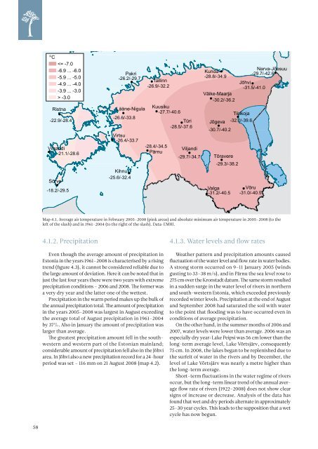
Ristna<br />
-22.9/-28.4<br />
Vilsandi<br />
-21.1/-28.6<br />
Sõrve<br />
-3.0<br />
-18.2/-29.5<br />
Pakri<br />
-26.2/-29.7<br />
Tallinn<br />
-26.9/-32.2<br />
Lääne-Nigula<br />
Kuusiku<br />
-27.7/-40.6<br />
-26.6/-33.8<br />
Türi<br />
-28.5/-37.6<br />
Virtsu<br />
-26.4/-33.7<br />
-28.4/-34.5<br />
Viljandi<br />
Pärnu<br />
-29.7/-34.7<br />
Kihnu<br />
-25.6/-32.4<br />
Narva-Jõesuu<br />
Kunda<br />
-29.7/-42.6<br />
-28.8/-34.9<br />
Jõhvi<br />
-31.5/-41.0<br />
Väike-Maarja<br />
-30.2/-36.2<br />
Tiirikoja<br />
Jõgeva -32.0/-39.6<br />
-30.7/-40.2<br />
Tõravere<br />
-29.3/-38.2<br />
Valga<br />
Võru<br />
-31.2/-40.5 -31.0/-40.5<br />
Map 4.1. Average air temperature in February 2005–2008 (pink areas) and absolute minimum air temperature in 2005–2008 (to the<br />
left of the slash) and in 1961–2004 (to the right of the slash). Data: EMHI.<br />
4.1.2. Precipitation<br />
Even though the average amount of precipitation in<br />
Estonia in the years 1961–2008 is characterised by a rising<br />
trend (figure 4.3), it cannot be considered reliable due to<br />
the large amount of deviation. Here it can be noted that in<br />
just the last four years there were two years with extreme<br />
precipitation conditions – 2006 and 2008. The former was<br />
a very dry year and the latter one of the wettest.<br />
Precipitation in the warm period makes up the bulk of<br />
the annual precipitation total. The amount of precipitation<br />
in the years 2005–2008 was largest in August exceeding<br />
the average total of August precipitation in 1961–2004<br />
by 37%. Also in January the amount of precipitation was<br />
larger than average.<br />
The greatest precipitation amount fell in the southwestern<br />
and western part of the Estonian mainland;<br />
considerable amount of precipitation fell also in the Jõhvi<br />
area. In Jõhvi also a new precipitation record for a 24-hour<br />
period was set – 116 mm on 21 August 2008 (map 4.2).<br />
4.1.3. Water levels and flow rates<br />
Weather pattern and precipitation amounts caused<br />
fluctuation of the water level and flow rate in water bodies.<br />
A strong storm occurred on 9–11 January 2005 (winds<br />
gusting to 33–38 m/s), and in Pärnu the sea level rose to<br />
275 cm over the Kronstadt datum. The same storm resulted<br />
in a sudden surge in the water level of rivers in northern<br />
and south-western Estonia, which exceeded previously<br />
recorded winter levels. Precipitation at the end of August<br />
and September 2008 had saturated the soil with water<br />
to the point that flooding was to have occurred even in<br />
conditions of average precipitation.<br />
On the other hand, in the summer months of 2006 and<br />
2007, water levels were lower than average. 2006 was an<br />
especially dry year: Lake Peipsi was 56 cm lower than the<br />
long-term average level, Lake Võrtsjärv, consequently<br />
75 cm. In 2008, the lakes began to be replenished due to<br />
the surfeit of water in the rivers and by December, the<br />
level of Lake Võrtsjärv was nearly a metre higher than<br />
the long-term average.<br />
Short-term fluctuations in the water regime of rivers<br />
occur, but the long-term linear trend of the annual average<br />
flow rate of rivers (1922–2008) does not show clear<br />
signs of increase or decrease. Analysis of the data has<br />
found that wet and dry periods alternate in approximately<br />
25–30 year cycles. This leads to the supposition that a wet<br />
cycle has now begun.<br />
58