- Page 2 and 3: TABLE OF CONTENTS Pages FOREWORD...
- Page 4 and 5: 4.3.8 Future Strategy:.............
- Page 6 and 7: FOREWORD 1. As we approach the 21st
- Page 8 and 9: December, 1998 vii
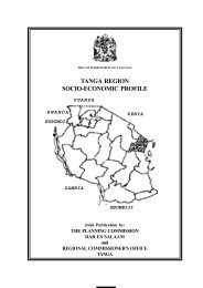
- Page 10 and 11: Kilimanjaro region is divided into
- Page 12 and 13: Wachagga was defeated and the Germa
- Page 14 and 15: Fig. 2: Population Distribution by
- Page 16 and 17: Fig. 3a: Population Census Results
- Page 18 and 19: Total 23,170,993 19.8 26.2 32 Sourc
- Page 21 and 22: Fig. 3c: Thousands 160 140 120 100
- Page 23 and 24: TABLE V(c): POPULATION DISTRIBUTION
- Page 25 and 26: Source: Population Census 1988, Kil
- Page 27 and 28: Table VI: Lifetime Migration By Reg
- Page 29 and 30: Mwanga 1143 16185 347 15338 33013 S
- Page 31 and 32: The Kilimanjaro region comprised of
- Page 33: Table VIII: SUMMARY OF AGRO-ECONOMI
- Page 37 and 38: 1.12 Land Scarcity: Crop production
- Page 39 and 40: However devaluation of the T.shilli
- Page 41 and 42: Fig. 4a: Regional GDP at Current Pr
- Page 43: Table XI: Comparison of Per Capita
- Page 46 and 47: 8. Literacy rate (1988) (%) 61.2 95
- Page 48 and 49: 2.4.1.1 The Coffee Zone: The zone i
- Page 50 and 51: The forestry zone in the district o
- Page 52 and 53: 700000 600000 500000 400000 300000
- Page 54 and 55: 45000 40000 35000 30000 25000 20000
- Page 56 and 57: Fig. 6: Hectares Under Coffee Produ
- Page 58 and 59: which renders stored crops vulnerab
- Page 60 and 61: Total 28 2 508 Source: TFNC Report
- Page 62 and 63: supply for irrigation purposes eith
- Page 64 and 65: 2.4.1.11 Farm Inputs: TABLE XIX: Av
- Page 66 and 67: of grazing land, livestock keeping
- Page 68 and 69: 200000 180000 160000 140000 120000
- Page 70 and 71: mixed breeds of Zebu and Exotic. Th
- Page 72 and 73: TAB LE XXVI: INVOLVEMENT OF RELIGIO
- Page 74 and 75: TABLE XXVII: ABATTOIRS AND LIVESTOC
- Page 76 and 77: TABLE XXIX: SPREAD OF NATURAL FORES
- Page 78 and 79: TABLE: XXX: SEEDLINGS RAISED AND HE
- Page 80: number of bovine out numbers the ca
- Page 83 and 84: TABLE XXXIV: FISH CATCH IN KILIMANJ
- Page 85 and 86:
Bee-keeping has great potential in
- Page 87 and 88:
Source: RDD’s Office, Kilimanjaro
- Page 89 and 90:
TABLE XXXVIIa: INDUSTRIAL OUTPUT (0
- Page 91 and 92:
20. Meatheru Industries Metal Works
- Page 93:
is low in terms of area in the Pare
- Page 96 and 97:
KILIMANJARO REGIONAL ROAD NETWORK 8
- Page 98 and 99:
Airport situated a few kilometers f
- Page 100 and 101:
telecomms, manual telephone exchang
- Page 102 and 103:
Moshi Urban 1 20 25 24 Total 35 685
- Page 104:
TABLE XLIII(b): DISTRIBUTION OF PRI
- Page 107 and 108:
TABLE: XLVI: STD. I ENROLMENT RATE
- Page 109 and 110:
Moshi (U) Total Boys Girls Total Bo
- Page 111 and 112:
Same 2287 2294 4584 518 512 1030 22
- Page 113 and 114:
TABLE: L: NUMBER OF PUPILS WHO PASS
- Page 115 and 116:
4.1.3 Drop-outs: Drop-outs in prima
- Page 117 and 118:
Cont’d. District 1998 Boys Girs T
- Page 119 and 120:
Table LIV below shows higher levels
- Page 121 and 122:
1800 1600 1400 1200 1000 800 600 40
- Page 123 and 124:
115 Furnitures Required Actual S h
- Page 125 and 126:
Furnitures Required Actual S h o r
- Page 127 and 128:
Total 162 0 217 7 379 7 142 0 309 2
- Page 129 and 130:
Students/ Teacher Ratio 33 41 45 56
- Page 131 and 132:
1. Kilimanjaro 2. Arusha 3. Iringa
- Page 133 and 134:
Fig. 22a: Total Enrolment in Second
- Page 135 and 136:
Total 17 Teachers Training Colleges
- Page 137 and 138:
TABLE LXIII: PERCENT LITERATE FOR P
- Page 139 and 140:
Mara 73.7 88.0 75.3 53.7 71.5 55.6
- Page 141 and 142:
TABLE LXV GROWTH STATUS AND DISTRIB
- Page 143 and 144:
. In turn, the District Authorizes
- Page 145 and 146:
Table LXVII above indicates that po
- Page 147 and 148:
Hai 3 - 3 75,974 49 - 49 Moshi R 2
- Page 149 and 150:
TABLE LXX: ACCESSIBILITY TO RURAL H
- Page 151 and 152:
The regional population per physici
- Page 153 and 154:
TABLE LXXII: LIFE EXPECTANCY AT BIR
- Page 155 and 156:
(b) Infant and Child Mortality Rate
- Page 157 and 158:
TABLE LXXIII (b): MATERNAL MORTALIT
- Page 159 and 160:
TABLE LXXIV: VACCINATION COVERAGE 1
- Page 161 and 162:
TABLE LXXV (b): HIV/AIDS INFECTION
- Page 163 and 164:
There is a total of 111 water sourc
- Page 165 and 166:
District Number of villages Village
- Page 167 and 168:
There are a number of problems faci
- Page 169 and 170:
vii) Cost Sharing: Most people are
- Page 171 and 172:
Water supply in urban Moshi and Sam
- Page 173 and 174:
supported sanitation in Hai distric
- Page 175 and 176:
Same - 5,719 7 more women 30,337 5.
- Page 177 and 178:
5.1.4 Economic Activities Undertake
- Page 179 and 180:
(e) Rombo District Project/Activity
- Page 181 and 182:
Others 6 1 3 1 1 8 2 Total 69 34 77
- Page 183 and 184:
8. Dambo Development Association fo
- Page 185 and 186:
16. World Vision Tanzania Northern
- Page 187 and 188:
SECTION VI 6.0 POTENTIAL INVESTIMEN
- Page 189 and 190:
e effective partners in the develop
- Page 191 and 192:
women could be enhanced through pro
- Page 193 and 194:
Population annual growth rate - 2.1
- Page 195 and 196:
187
- Page 197 and 198:
- Shortage of desks - 16,313 - Chai
- Page 199 and 200:
4.0 ECONOMIC INFRASTRUCTURES: 4.1 (
- Page 201 and 202:
Rainfall - 700-2000mm per annum Tem
- Page 203 and 204:
3.3 Water: - Rural population cover
- Page 205 and 206:
197
- Page 207 and 208:
3.0 SOCIAL SERVICES: 3.1 Education:
- Page 209 and 210:
ANNEX D SAME DISTRICT 1.0 GENERAL:
- Page 211 and 212:
- Number of pupils - 40,964 - Class
- Page 213 and 214:
3.3 Water: - Rural population cover
- Page 215 and 216:
Temperature - 14 0 C - 25 0 C 2.0 E
- Page 217 and 218:
Rural Health Centres - 3 Dispensari
- Page 219 and 220:
MOSHI RURAL DISTRICT 1.0 GENERAL: A
- Page 221 and 222:
(a) Primary School Facilities (1998
- Page 223 and 224:
3.3 Water: - Population (Rural) cov
- Page 225 and 226:
217
- Page 227 and 228:
Male - 21 Female - 275 (c) Narsery
- Page 229 and 230:
Kilimanjaro 13,309 Shinyanga 50,781
- Page 231 and 232:
Land Use (Ha (millions) Proportion
- Page 233 and 234:
1.2 SOCIAL SERVICES HEALTH FACILITI
- Page 235 and 236:
(iii) TARANGIRE NATIONAL PARK LOCAT
- Page 237 and 238:
(viii)RUAHA NATIONAL PARK LOCATION: