- Page 1:
MTP 1(D), Vol. I MTP 1(D) VOLUME I
- Page 5:
MTP 1(D), Vol. I April 2004 PUBLICA
- Page 9 and 10:
MTP 1(D), Vol. I RECORD OF RESERVAT
- Page 14 and 15:
MTP 1(D), Vol. I RECORD OF CHANGES
- Page 16 and 17:
1240 COMMAND IN OPERATION AWKWARD .
- Page 18 and 19:
2110 STANDARD POSITIONS/REFERENCE P
- Page 20 and 21:
MTP 1(D), Vol. I Page No. SECTION I
- Page 22 and 23:
4175 CONVOY COMMUNICATIONS ........
- Page 24 and 25:
MTP 1(D), Vol. I Page No. SECTION V
- Page 26 and 27:
6342 Integration With Standard Tact
- Page 29 and 30:
6444 NOT RELEASABLE ...............
- Page 31 and 32:
6736 NOT RELEASABLE ...............
- Page 33 and 34:
MTP 1(D), Vol. I Page No. CHAPTER 8
- Page 35 and 36:
9120 ASW FIXED-WING AIRCRAFT ......
- Page 37 and 38:
9350 NOT RELEASABLE ...............
- Page 39 and 40:
12021 NOT RELEASABLE ..............
- Page 41 and 42:
LIST OF ILLUSTRATIONS MTP 1(D), Vol
- Page 43 and 44:
MTP 1(D), Vol. I Page No. CHAPTER 9
- Page 45 and 46:
MTP 1(D), Vol. I Page No. CHAPTER 6
- Page 47 and 48:
PREFACE MTP 1(D), Vol. I 1. MTP 1,
- Page 49:
MTP 1(D), Vol. I PART I General Cha
- Page 52 and 53:
MTP 1(D), Vol. I COMMON SUPERIOR CT
- Page 54 and 55:
MTP 1(D), Vol. I 1203 DELEGATION OF
- Page 56 and 57:
inform the operational control auth
- Page 58 and 59: MTP 1(D), Vol. I c. OPSTAT RAS. For
- Page 60 and 61: MTP 1(D), Vol. I 1250 COMMAND IN SU
- Page 62 and 63: exercise of professional judgment i
- Page 64 and 65: MTP 1(D), Vol. I g. Sensor capabili
- Page 66 and 67: MTP 1(D), Vol. I 1300 INTRODUCTION
- Page 68 and 69: MTP 1(D), Vol. I b. Principal Warfa
- Page 70 and 71: MTP 1(D), Vol. I c. Specific Antisu
- Page 72 and 73: MTP 1(D), Vol. I (d) The EWC must e
- Page 74 and 75: (3) Rescue Destroyer. During flight
- Page 76 and 77: MTP 1(D), Vol. I TF 419 CTF 419 COM
- Page 78 and 79: MTP 1(D), Vol. I Table 1-1. OTC’s
- Page 80 and 81: MTP 1(D), Vol. I Table 1-1. OTC’s
- Page 82 and 83: MTP 1(D), Vol. I Table 1-2. OTC’s
- Page 84 and 85: MTP 1(D), Vol. I Table 1-3. OTC’s
- Page 86 and 87: MTP 1(D), Vol. I Table 1-4. OTC’s
- Page 88 and 89: MTP 1(D), Vol. I Table 1-6. OTC’s
- Page 90 and 91: MTP 1(D), Vol. I Table 1-8. OTC’s
- Page 92 and 93: MTP 1(D), Vol. I Table 1-9. OTC’s
- Page 94 and 95: Table 1-11. OTC’s Responsibilitie
- Page 96 and 97: MTP 1(D), Vol. I Table 1-12. MTMS M
- Page 98 and 99: MTP 1(D), Vol. I c. NOT RELEASABLE
- Page 100 and 101: MTP 1(D), Vol. I (b) Navigational s
- Page 102 and 103: MTP 1(D), Vol. I b. The OTC will pr
- Page 104 and 105: MTP 1(D), Vol. I -EXAMPLES- 2 fight
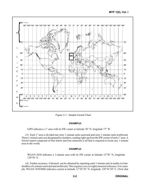
- Page 107: CHAPTER 2 Position, Movement, and M
- Page 111 and 112: MTP 1(D), Vol. I b. When Reporting
- Page 113 and 114: (1) Friendly Air Tracks. The altitu
- Page 115 and 116: MTP 1(D), Vol. I f. Changing the DL
- Page 117 and 118: MTP 1(D), Vol. I b. Doubt of Positi
- Page 119 and 120: When proceeding to berths in format
- Page 121 and 122: MTP 1(D), Vol. I 500 YDS 500 YDS 50
- Page 123 and 124: MTP 1(D), Vol. I KNOTS MINUTES RATE
- Page 125 and 126: (1) The ship in which the OTC is em
- Page 127 and 128: International Regulations for Preve
- Page 129 and 130: (4) The rear ship should always pre
- Page 131 and 132: MTP 1(D), Vol. I 2270 NIGHT AND FOG
- Page 133 and 134: MTP 1(D), Vol. I SECTION III — EV
- Page 135 and 136: MTP 1(D), Vol. I This page — NOT
- Page 137: MTP 1(D), Vol. I This page — NOT
- Page 141 and 142: MTP 1(D), Vol. I CHAPTER 3 Disposit
- Page 143 and 144: MTP 1(D), Vol. I 3110 GENERAL TYPES
- Page 145 and 146: MTP 1(D), Vol. I 0 AXIS COURSE SHIP
- Page 147 and 148: MTP 1(D), Vol. I Figure 3-3. Rotati
- Page 149 and 150: MTP 1(D), Vol. I Figure 3-5 — NOT
- Page 151 and 152: MTP 1(D), Vol. I Figure 3-7. Transp
- Page 153 and 154: MTP 1(D), Vol. I Figure 3-8 — NOT
- Page 155 and 156: MTP 1(D), Vol. I Figure 3-10 — NO
- Page 157 and 158: MTP 1(D), Vol. I Figure 3-11. Reple
- Page 159 and 160:
90 270 MTP 1(D), Vol. I 310 130 320
- Page 161 and 162:
MTP 1(D), Vol. I Figure 3-15. Reple
- Page 163 and 164:
MTP 1(D), Vol. I 3200 GENERAL TYPES
- Page 165 and 166:
MTP 1(D), Vol. I Figure 3-17. Speci
- Page 167 and 168:
MTP 1(D), Vol. I Figure 3-18 — NO
- Page 169 and 170:
MTP 1(D), Vol. I 3215 NOT RELEASABL
- Page 171 and 172:
(1) In this disposition, task group
- Page 173 and 174:
MTP 1(D), Vol. I 3218 4W DISPOSITIO
- Page 175 and 176:
90 MTP 1(D), Vol. I 320 330 340 350
- Page 177 and 178:
MTP 1(D), Vol. I Table 3-4. — NOT
- Page 179 and 180:
MTP 1(D), Vol. I (2) Characteristic
- Page 181 and 182:
MTP 1(D), Vol. I Figure 3-22 — NO
- Page 183 and 184:
MTP 1(D), Vol. I a P O 30° 30° N
- Page 185 and 186:
MTP 1(D), Vol. I the East-West dime
- Page 187 and 188:
MTP 1(D), Vol. I c. Wheeling by Mai
- Page 189 and 190:
MTP 1(D), Vol. I 3337 — 3339 SPAR
- Page 191 and 192:
MTP 1(D), Vol. I CHAPTER 4 Communic
- Page 193 and 194:
MTP 1(D), Vol. I 4121 NET CONTROL S
- Page 195 and 196:
Voice communications must be used t
- Page 197 and 198:
MTP 1(D), Vol. I Table 4-1. Authent
- Page 199 and 200:
zone coordinator (IDZC) upon launch
- Page 201 and 202:
MTP 1(D), Vol. I b. TF/TG Reporting
- Page 203 and 204:
MTP 1(D), Vol. I 4172 SUBMARINE BRO
- Page 205 and 206:
MTP 1(D), Vol. I 4174 SUBMARINE REP
- Page 207 and 208:
(2) HF communications will normally
- Page 209:
SECTION II — TACTICAL ASPECTS OF
- Page 212 and 213:
MTP 1(D), Vol. I c. Acoustic Warfar
- Page 215 and 216:
(6) Correlate information obtained
- Page 217 and 218:
MTP 1(D), Vol. I SECTION II — NOT
- Page 219 and 220:
MTP 1(D), Vol. I This page — NOT
- Page 221:
MTP 1(D), Vol. I b. The status of e
- Page 224 and 225:
INDEX NUMBERS EQUIPMENT INDEX LETTE
- Page 226 and 227:
MTP 1(D), Vol. I 5320 NOT RELEASABL
- Page 228 and 229:
MTP 1(D), Vol. I This page — NOT
- Page 230 and 231:
MTP 1(D), Vol. I SECTION V — EMPL
- Page 232 and 233:
MTP 1(D), Vol. I SECTION VI — NOT
- Page 234 and 235:
MTP 1(D), Vol. I This page — NOT
- Page 236 and 237:
MTP 1(D), Vol. I 5723 REDUCING THE
- Page 238 and 239:
MTP 1(D), Vol. I SECTION VIII — N
- Page 240 and 241:
MTP 1(D), Vol. I This page — NOT
- Page 242 and 243:
MTP 1(D), Vol. I 6200 INTRODUCTION
- Page 244 and 245:
MTP 1(D), Vol. I (2) Speed. d. WHEN
- Page 246 and 247:
MTP 1(D), Vol. I (h) A contact view
- Page 248 and 249:
MTP 1(D), Vol. I FUNCTION OPERATION
- Page 250 and 251:
MTP 1(D), Vol. I b. Reconnaissance.
- Page 252 and 253:
MTP 1(D), Vol. I 6260 TASKS Based o
- Page 254 and 255:
MTP 1(D), Vol. I 6270 PICTURE COMPI
- Page 256 and 257:
MTP 1(D), Vol. I 6300 DATA COMPILAT
- Page 258 and 259:
MTP 1(D), Vol. I c. Issue SITREPs.
- Page 260 and 261:
MTP 1(D), Vol. I Visual sighting ca
- Page 262 and 263:
c. The OTC, along with the rest of
- Page 264 and 265:
MTP 1(D), Vol. I Table 6-2 — NOT
- Page 266 and 267:
MTP 1(D), Vol. I 6352 GATEWAY UNIT
- Page 268 and 269:
executed. The subject unit uses its
- Page 270 and 271:
MTP 1(D), Vol. I SECTION IV — AIR
- Page 272 and 273:
MTP 1(D), Vol. I Table 6-3. Table o
- Page 274 and 275:
MTP 1(D), Vol. I 6410 PROCEDURES FO
- Page 277 and 278:
MTP 1(D), Vol. I Table 6-4. Checkli
- Page 279 and 280:
MTP 1(D), Vol. I Table 6-4. Checkli
- Page 281 and 282:
MTP 1(D), Vol. I 6416 DEFINITIONS T
- Page 283 and 284:
g. Approach Corridor. The approach
- Page 285 and 286:
MTP 1(D), Vol. I f. Relaying tactic
- Page 287 and 288:
MTP 1(D), Vol. I (c) Employment/Air
- Page 289 and 290:
MTP 1(D), Vol. I Table 6-5A/1 — N
- Page 291 and 292:
MTP 1(D), Vol. I 6432 THROUGH 6434
- Page 293 and 294:
a. Actions on Gaining Contact. On g
- Page 295 and 296:
MTP 1(D), Vol. I This page — NOT
- Page 297 and 298:
MTP 1(D), Vol. I Table 6-6 — NOT
- Page 299 and 300:
MTP 1(D), Vol. I 6453 INDEPENDENT O
- Page 301 and 302:
MTP 1(D), Vol. I c. Inability to Ex
- Page 303 and 304:
MTP 1(D), Vol. I b. Joining Procedu
- Page 305 and 306:
MTP 1(D), Vol. I NOTE Below 2,000 f
- Page 307 and 308:
MTP 1(D), Vol. I Table 6-9. Altitud
- Page 309 and 310:
MTP 1(D), Vol. I 6505 CARRIER OPERA
- Page 311 and 312:
(2) The screen coordinator is to no
- Page 313 and 314:
MTP 1(D), Vol. I Table 6-10. Night
- Page 315 and 316:
MTP 1(D), Vol. I 6532 through 6533
- Page 317 and 318:
MTP 1(D), Vol. I 6534 — 6539 SPAR
- Page 319 and 320:
MTP 1(D), Vol. I c. On entering the
- Page 321 and 322:
MTP 1(D), Vol. I 6560 through 6562
- Page 323 and 324:
MTP 1(D), Vol. I This page — NOT
- Page 325 and 326:
MTP 1(D), Vol. I c. Pilot Voice Rep
- Page 327 and 328:
MTP 1(D), Vol. I Table 6-13. Signal
- Page 329 and 330:
MTP 1(D), Vol. I Table 6-14. Rescue
- Page 331 and 332:
MTP 1(D), Vol. I Table 6-15. Night
- Page 333 and 334:
MTP 1(D), Vol. I 6700 SCOPE SECTION
- Page 335 and 336:
MTP 1(D), Vol. I (1) Aircraft ident
- Page 337 and 338:
ombing zone without prior timely no
- Page 339:
MTP 1(D), Vol. I This page — NOT
- Page 342 and 343:
MTP 1(D), Vol. I This page — NOT
- Page 345 and 346:
MTP 1(D), Vol. I This page — NOT
- Page 347 and 348:
MTP 1(D), Vol. I This page — NOT
- Page 349 and 350:
MTP 1(D), Vol. I 6737 PROCEDURES FO
- Page 351 and 352:
MTP 1(D), Vol. I (2) A particular c
- Page 353 and 354:
MTP 1(D), Vol. I 6753 RADIATION HAZ
- Page 355 and 356:
MTP 1(D), Vol. I ASW weapons may be
- Page 357 and 358:
MTP 1(D), Vol. I This page — NOT
- Page 359 and 360:
MTP 1(D), Vol. I This page — NOT
- Page 361 and 362:
MTP 1(D), Vol. I Figure 6-13 — NO
- Page 363 and 364:
MTP 1(D), Vol. I 6764 SAFETY LANES
- Page 365 and 366:
SUBNOTE. Should it be necessary to
- Page 367 and 368:
(2) VDS may be employed in the acti
- Page 369:
(2) The SMAA will check MW Notes fo
- Page 373 and 374:
MTP 1(D), Vol. I CHAPTER 7 Antiair
- Page 375 and 376:
MTP 1(D), Vol. I 7004 FORCE TRACK C
- Page 377 and 378:
MTP 1(D), Vol. I (2) NOT RELEASABLE
- Page 379 and 380:
MTP 1(D), Vol. I (b) Medium (MEDIUM
- Page 381 and 382:
MTP 1(D), Vol. I 7040 ANTIAIR WARFA
- Page 383 and 384:
MTP 1(D), Vol. I FIGHTER ENGAGEMENT
- Page 385 and 386:
MTP 1(D), Vol. I 7052 TARGET ENGAGE
- Page 387 and 388:
MTP 1(D), Vol. I Table 7-1 NOT RELE
- Page 389 and 390:
MTP 1(D), Vol. I 7064 NOT RELEASABL
- Page 391 and 392:
MTP 1(D), Vol. I This page — NOT
- Page 393 and 394:
MTP 1(D), Vol. I CHAPTER 8 Antisurf
- Page 395 and 396:
MTP 1(D), Vol. I Table 8-1. Surface
- Page 397 and 398:
MTP 1(D), Vol. I Table 8-1. Surface
- Page 399 and 400:
MTP 1(D), Vol. I Table 8-1. Surface
- Page 401 and 402:
MTP 1(D), Vol. I SECTION II — ANT
- Page 403 and 404:
(1) Normal fire distribution. Norma
- Page 405 and 406:
helicopter will provide all availab
- Page 407 and 408:
MTP 1(D), Vol. I Figure 8-1 — NOT
- Page 409 and 410:
MTP 1(D), Vol. I This page — NOT
- Page 411 and 412:
MTP 1(D), Vol. I SECTION IV — NOT
- Page 413 and 414:
MTP 1(D), Vol. I SECTION V — THIR
- Page 415 and 416:
MTP 1(D), Vol. I (3) Maritime patro
- Page 417 and 418:
MTP 1(D), Vol. I Table 8-2 — NOT
- Page 419 and 420:
MTP 1(D), Vol. I (1) Actions which
- Page 421 and 422:
cases, an alteration of course by t
- Page 423 and 424:
MTP 1(D), Vol. I Figure 8-2 — NOT
- Page 425 and 426:
MTP 1(D), Vol. I Figure 8-2 (Cont.)
- Page 427 and 428:
MTP 1(D), Vol. I Figure 8-2 (Cont.)
- Page 429 and 430:
a. Demonstrate Forward Presence. Th
- Page 431 and 432:
a. That the task, pertinent ROE and
- Page 433 and 434:
MTP 1(D), Vol. I Table 8-5. Multina
- Page 435 and 436:
MTP 1(D), Vol. I (3) Maintenance of
- Page 437 and 438:
more flexibility and minimize the r
- Page 439 and 440:
(c) Units selected should possess s
- Page 441 and 442:
MTP 1(D), Vol. I (2) Psychological
- Page 443 and 444:
MTP 1(D), Vol. I CHAPTER 9 Antisubm
- Page 445:
MTP 1(D), Vol. I b. Predicted Sonar
- Page 448 and 449:
MTP 1(D), Vol. I SECTION I — EMPL
- Page 450 and 451:
MTP 1(D), Vol. I NOT RELEASABLE (6)
- Page 452 and 453:
MTP 1(D), Vol. I 9109 TOWED ARRAY Z
- Page 454 and 455:
9122 CONDUCT OF AIRPLANS FOR FIXED-
- Page 456 and 457:
MTP 1(D), Vol. I Figure 9-1 — NOT
- Page 458 and 459:
MTP 1(D), Vol. I This page — NOT
- Page 461 and 462:
MTP 1(D), Vol. I This page — NOT
- Page 463 and 464:
MTP 1(D), Vol. I This page — NOT
- Page 465 and 466:
MTP 1(D), Vol. I 9200 GENERAL CONSI
- Page 467 and 468:
(2) Active or passive sonar, MAD, r
- Page 469 and 470:
MTP 1(D), Vol. I 9204 — 9209 SPAR
- Page 471:
MTP 1(D), Vol. I This page — NOT
- Page 474 and 475:
MTP 1(D), Vol. I Table 9-4. ASW Sea
- Page 476 and 477:
MTP 1(D), Vol. I (b) Identity of th
- Page 479 and 480:
MTP 1(D), Vol. I d. NOT RELEASABLE
- Page 481 and 482:
MTP 1(D), Vol. I This page — NOT
- Page 483 and 484:
MTP 1(D), Vol. I Table 9-6. Coordin
- Page 485 and 486:
c. Visual On Top. When the aircraft
- Page 487 and 488:
MTP 1(D), Vol. I This page — NOT
- Page 489 and 490:
MTP 1(D), Vol. I 9254 — 9259 SPAR
- Page 491 and 492:
MTP 1(D), Vol. I Method Code Purpos
- Page 493 and 494:
MTP 1(D), Vol. I 9264 NOT RELEASABL
- Page 495 and 496:
MTP 1(D), Vol. I This page — NOT
- Page 497 and 498:
MTP 1(D), Vol. I This page — NOT
- Page 499 and 500:
MTP 1(D), Vol. I This page — NOT
- Page 501 and 502:
MTP 1(D), Vol. I This page — NOT
- Page 503 and 504:
MTP 1(D), Vol. I This page — NOT
- Page 505 and 506:
MTP 1(D), Vol. I Table 9-12 — NOT
- Page 507 and 508:
MTP 1(D), Vol. I This page — NOT
- Page 509 and 510:
MTP 1(D), Vol. I Table 9-13 (Cont.)
- Page 511 and 512:
MTP 1(D), Vol. I Table 9-13 (Cont.)
- Page 513 and 514:
MTP 1(D), Vol. I Figure 9-5 — NOT
- Page 515 and 516:
MTP 1(D), Vol. I Figure 9-7 — NOT
- Page 517 and 518:
MTP 1(D), Vol. I Figure 9-8 — NOT
- Page 519 and 520:
MTP 1(D), Vol. I Figure 9-9 — NOT
- Page 521 and 522:
MTP 1(D), Vol. I Figure 9-10 (Cont.
- Page 523 and 524:
MTP 1(D), Vol. I Figure 9-11 (Cont.
- Page 525 and 526:
MTP 1(D), Vol. I Figure 9-12 (Cont.
- Page 527 and 528:
MTP 1(D), Vol. I Figure 9-13 (Cont.
- Page 529 and 530:
MTP 1(D), Vol. I Figure 9-14 (Cont.
- Page 531 and 532:
MTP 1(D), Vol. I Figure 9-16 — NO
- Page 533 and 534:
MTP 1(D), Vol. I Figure 9-18 — NO
- Page 535 and 536:
MTP 1(D), Vol. I Figure 9-20 — NO
- Page 537 and 538:
MTP 1(D), Vol. I SEARCH PLAN 1S OAK
- Page 539 and 540:
MTP 1(D), Vol. I Figure 9-23 (Cont.
- Page 541:
MTP 1(D), Vol. I Fig ure 9-24 — N
- Page 544 and 545:
(8) More opportunities for training
- Page 546 and 547:
MTP 1(D), Vol. I f. NCAGS Liaison O
- Page 548 and 549:
10023 IMPLICATIONS OF NON-COMPLIANC
- Page 551 and 552:
MTP 1(D), Vol. I CHAPTER 11 Amphibi
- Page 553 and 554:
conducted in some detail before any
- Page 555 and 556:
(11) Inshore Undersea Warfare Group
- Page 557 and 558:
MTP 1(D), Vol. I NAVY AMPHIBIOUS PL
- Page 559 and 560:
MTP 1(D), Vol. I (R) 11020 DESIGNAT
- Page 561 and 562:
MTP 1(D), Vol. I non-essential nets
- Page 563 and 564:
MTP 1(D), Vol. I CHAPTER 12 NBC War
- Page 565 and 566:
MTP 1(D), Vol. I Table 12-1 — NOT
- Page 567 and 568:
MTP 1(D), Vol. I 12012 and 12013 NO
- Page 569 and 570:
12-7 ORIGINAL PREPARATION 1. Use an
- Page 571 and 572:
MTP 1(D), Vol. I b. Expected yield
- Page 573 and 574:
MTP 1(D), Vol. I 12044 PROTECTION I
- Page 575 and 576:
MTP 1(D), Vol. I 12055 GENERAL TACT
- Page 577 and 578:
MTP 1(D), Vol. I 12059 CONTAMINATIO
- Page 579 and 580:
MTP 1(D), Vol. I CHAPTER 13 Mine Wa
- Page 581 and 582:
MTP 1(D), Vol. I 13008 — 13009 SP
- Page 583 and 584:
(3) Seabed Surveys. These surveys a
- Page 585 and 586:
MTP 1(D), Vol. I This page — NOT
- Page 587 and 588:
MTP 1(D), Vol. I This page — NOT
- Page 589 and 590:
MTP 1(D), Vol. I This page — NOT
- Page 591 and 592:
MTP 1(D), Vol. I 13036 — 13039 SP
- Page 593 and 594:
MTP 1(D), Vol. I NOTES: 1. MCM data
- Page 595 and 596:
MTP 1(D), Vol. I Table 13-1. Action
- Page 597 and 598:
MTP 1(D), Vol. I This page — NOT
- Page 599 and 600:
MTP 1(D), Vol. I This page — NOT
- Page 601:
MTP 1(D), Vol. I 13062 EVACUATION O
- Page 604 and 605:
MTP 1(D), Vol. I 14012 — 14019 SP
- Page 606 and 607:
MTP 1(D), Vol. I NOT RELEASABLE Sta
- Page 608 and 609:
MTP 1(D), Vol. I 14025 — 14029 SP
- Page 610 and 611:
MTP 1(D), Vol. I CAP. Combat air pa
- Page 612 and 613:
MTP 1(D), Vol. I FW. Fixed wing H H
- Page 614 and 615:
MTP 1(D), Vol. I NSA. National ship
- Page 616 and 617:
MTP 1(D), Vol. I T TACOM. Tactical
- Page 618 and 619:
aircraft control unit. A unit with
- Page 620 and 621:
MTP 1(D), Vol. I B barrier combat a
- Page 622 and 623:
MTP 1(D), Vol. I contact report. A
- Page 624 and 625:
disposition. An ordered arrangement
- Page 626 and 627:
estimated time of departure (ETD).
- Page 628 and 629:
MTP 1(D), Vol. I H handover (aircra
- Page 630 and 631:
line guide. When ships are formed i
- Page 632 and 633:
operational control (OPCON). The au
- Page 634 and 635:
MTP 1(D), Vol. I receiving ship. In
- Page 636 and 637:
sequence number. The number allocat
- Page 638 and 639:
submarine operating authority. The
- Page 640 and 641:
threat radar. A radar, the detectio
- Page 642 and 643:
weapon danger zone. In ASW operatio
- Page 644 and 645:
MTP 1(D), Vol. I Page No. After-act
- Page 646 and 647:
MTP 1(D), Vol. I Page No. NOT RELEA
- Page 648 and 649:
MTP 1(D), Vol. I Page No. NOT RELEA
- Page 650 and 651:
MTP 1(D), Vol. I Page No. Authoriti
- Page 652 and 653:
MTP 1(D), Vol. I Page No. When chan
- Page 654 and 655:
MTP 1(D), Vol. I Page No. Search at
- Page 656 and 657:
MTP 1(D), Vol. I Page No. Principle
- Page 658 and 659:
MTP 1(D), Vol. I Page No. Compilati
- Page 660 and 661:
MTP 1(D), Vol. I Page No. General t
- Page 662 and 663:
MTP 1(D), Vol. I Page No. Reports .
- Page 664 and 665:
MTP 1(D), Vol. I Page No. Full: Com
- Page 666 and 667:
MTP 1(D), Vol. I Page No. Support o
- Page 668 and 669:
MTP 1(D), Vol. I Page No. K Keep cl
- Page 670 and 671:
MTP 1(D), Vol. I Page No. Methods A
- Page 672 and 673:
MTP 1(D), Vol. I Page No. Full ....
- Page 674 and 675:
MTP 1(D), Vol. I Page No. Patrol or
- Page 676 and 677:
MTP 1(D), Vol. I Page No. Precautio
- Page 678 and 679:
MTP 1(D), Vol. I Page No. Wartime .
- Page 680 and 681:
MTP 1(D), Vol. I Page No. Responses
- Page 682 and 683:
MTP 1(D), Vol. I Page No. NOT RELEA
- Page 684 and 685:
MTP 1(D), Vol. I Page No. Launching
- Page 686 and 687:
MTP 1(D), Vol. I Page No. NOT RELEA
- Page 688 and 689:
MTP 1(D), Vol. I Page No. Suffixes,
- Page 690 and 691:
MTP 1(D), Vol. I Page No. Link 4 an
- Page 692 and 693:
MTP 1(D), Vol. I Page No. U Underwa
- Page 694 and 695:
MTP 1(D), Vol. I Page No. Zone(s):
- Page 697:
MTP 1(D), Vol. I LIST OF EFFECTIVE