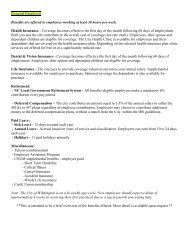
article 5. zoning district regulations - City of Wilmington
article 5. zoning district regulations - City of Wilmington
article 5. zoning district regulations - City of Wilmington

Create successful ePaper yourself
Turn your PDF publications into a flip-book with our unique Google optimized e-Paper software.
Land Development Code<br />
<strong>City</strong> <strong>of</strong> <strong>Wilmington</strong><br />
DIVISION III. OVERLAY DISTRICTS<br />
Sec. 18-211. FP, Flood Plain-Overlay District.<br />
(a) Purpose. The purpose for identifying this area on the <strong>zoning</strong> map is to alert all<br />
persons concerned to the fact that development within designated floodplains must<br />
conform to the adopted ordinance entitled "The Flood Plain Management Regulations<br />
<strong>of</strong> the <strong>City</strong> <strong>of</strong> <strong>Wilmington</strong>," as amended. It is the intent <strong>of</strong> the council <strong>of</strong> the <strong>City</strong> <strong>of</strong><br />
<strong>Wilmington</strong> to promote the public health, safety and general welfare with measures<br />
designed to minimize private and public losses <strong>of</strong> life, property, commerce and<br />
services from the hazards o f floods through the enforcement <strong>of</strong> the above-referenced<br />
ordinance.<br />
(b) District provisions. The Flood Plain-Overlay is established as a <strong>district</strong> which<br />
overlaps other <strong>zoning</strong> <strong>district</strong>s established by this chapter. The extent and boundaries<br />
<strong>of</strong> the Flood Plain-Overlay <strong>district</strong> shall be delineated on the <strong>of</strong>ficial <strong>zoning</strong> map <strong>of</strong><br />
the <strong>City</strong> <strong>of</strong> <strong>Wilmington</strong>, but final determination shall be identified from the flood<br />
hazard boundary maps (FPBM), No. 370171-0001A and No. 370171-0002A, dated<br />
April 17, 1978 and any subsequent revisions thereto; or from "The Flood Insurance<br />
Study for the <strong>City</strong> <strong>of</strong> <strong>Wilmington</strong>, North Carolina," dated April 17, 1978, with<br />
accompanying flood insurance rate maps, and flood boundary and special flood<br />
hazard maps and any subsequent revisions thereto. While the Flood Plain-Overlay<br />
District may overlap any <strong>zoning</strong> <strong>district</strong> classification, or any portion there<strong>of</strong>,<br />
established by this Chapter, the land use provisions <strong>of</strong> the underlying <strong>district</strong> shall<br />
prevail in the development <strong>of</strong> any property within such <strong>district</strong>; provided, the<br />
provisions <strong>of</strong> the above-referenced "Flood Plain Management Regulations <strong>of</strong> the <strong>City</strong><br />
<strong>of</strong> <strong>Wilmington</strong>" are adhered to in any construction, reconstruction and alteration to<br />
the land and/or structures within this <strong>district</strong>.<br />
ARTICLE <strong>5.</strong> ZONING DISTRICT REGULATIONS Page 112