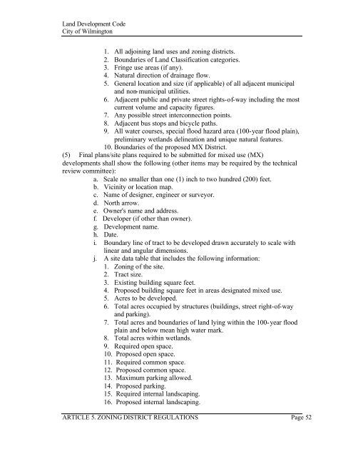
article 5. zoning district regulations - City of Wilmington
article 5. zoning district regulations - City of Wilmington
article 5. zoning district regulations - City of Wilmington

Create successful ePaper yourself
Turn your PDF publications into a flip-book with our unique Google optimized e-Paper software.
Land Development Code<br />
<strong>City</strong> <strong>of</strong> <strong>Wilmington</strong><br />
1. All adjoining land uses and <strong>zoning</strong> <strong>district</strong>s.<br />
2. Boundaries <strong>of</strong> Land Classification categories.<br />
3. Fringe use areas (if any).<br />
4. Natural direction <strong>of</strong> drainage flow.<br />
<strong>5.</strong> General location and size (if applicable) <strong>of</strong> all adjacent municipal<br />
and non-municipal utilities.<br />
6. Adjacent public and private street rights-<strong>of</strong>-way including the most<br />
current volume and capacity figures.<br />
7. Any possible street interconnection points.<br />
8. Adjacent bus stops and bicycle paths.<br />
9. All water courses, special flood hazard area (100-year flood plain),<br />
preliminary wetlands delineation and unique natural features.<br />
10. Boundaries <strong>of</strong> the proposed MX District.<br />
(5) Final plans/site plans required to be submitted for mixed use (MX)<br />
developments shall show the following (other items may be required by the technical<br />
review committee):<br />
a. Scale no smaller than one (1) inch to two hundred (200) feet.<br />
b. Vicinity or location map.<br />
c. Name <strong>of</strong> designer, engineer or surveyor.<br />
d. North arrow.<br />
e. Owner's name and address.<br />
f. Developer (if other than owner).<br />
g. Development name.<br />
h. Date.<br />
i. Boundary line <strong>of</strong> tract to be developed drawn accurately to scale with<br />
linear and angular dimensions.<br />
j. A site data table that includes the following information:<br />
1. Zoning <strong>of</strong> the site.<br />
2. Tract size.<br />
3. Existing building square feet.<br />
4. Proposed building square feet in areas designated mixed use.<br />
<strong>5.</strong> Acres to be developed.<br />
6. Total acres occupied by structures (buildings, street right-<strong>of</strong>-way<br />
and parking).<br />
7. Total acres and boundaries <strong>of</strong> land lying within the 100-year flood<br />
plain and below mean high water mark.<br />
8. Total acres within wetlands.<br />
9. Required open space.<br />
10. Proposed open space.<br />
11. Required common space.<br />
12. Proposed common space.<br />
13. Maximum parking allowed.<br />
14. Proposed parking.<br />
1<strong>5.</strong> Required internal landscaping.<br />
16. Proposed internal landscaping.<br />
ARTICLE <strong>5.</strong> ZONING DISTRICT REGULATIONS Page 52