Local mitigation strategy (LMS) - Volusia County Government
Local mitigation strategy (LMS) - Volusia County Government
Local mitigation strategy (LMS) - Volusia County Government

You also want an ePaper? Increase the reach of your titles
YUMPU automatically turns print PDFs into web optimized ePapers that Google loves.
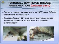
SECTION 5: HAZARD PROFILESHYDROLOGIC HAZARDS5.8 COASTAL EROSION5.8.1 BackgroundCoastal erosion is a hydrologic hazard defined as the wearing away of land and loss of beach, shoreline,or dune material and is measured as the rate of change in the position or horizontal (landward)displacement of a shoreline over a period of time. Short-term erosion typically results from episodicnatural events such as hurricanes and storm surge, windstorms and flooding hazards, but may beexacerbated by human activities such as boat wakes, removal of dune and vegetative buffers, shorelinehardening and dredging. Long-term erosion is a function of multi-year impacts such as wave action, sealevel rise, sediment loss, subsidence and climate change. Climatic trends can change a beach fromnaturally accreting to eroding due to increased episodic erosion events caused by waves from an aboveaveragenumber of storms and high tides, or the long-term effects of fluctuations in sea level.Natural recovery from erosion can take years, often decades. If a beach or dune system does notrecover quickly enough naturally, coastal and upland property may be exposed to further damage insubsequent coastal erosion and flooding events. Human actions to supplement natural coastal recovery,such as beach nourishment, dune stabilization and shoreline protection structures (e.g., sea walls,groins, jetties, etc.) can mitigate the hazard of coastal erosion, but may also exacerbate it under somecircumstances.Death and injury are not associated with coastal erosion; however, it can cause the destruction ofbuildings and infrastructure and represents a major threat to the local economies of coastalcommunities that rely on the financial benefits of recreational beaches.5.8.2 Location and Spatial ExtentAll coastal areas in <strong>Volusia</strong> <strong>County</strong> are susceptible to coastal erosion. Using Florida Department ofEnvironment field data beginning in 1972, it is clear that <strong>Volusia</strong> <strong>County</strong> shorelines are moving due toerosion, accretion, and beach nourishment projects 7 . Further, nearly half of the 47 miles of shoreline in<strong>Volusia</strong> <strong>County</strong> are classified as critically eroded.The beach ridge in <strong>Volusia</strong> <strong>County</strong> ranges from 300 – 3,000 feet in width. A majority of the county,ranging approximately from Ormond Beach to Bethune Beach, has fine-grained quartz sand. Sand inareas north and south of this area consist of a shell-quartz mixture and have steeper slopes than thecentral county. The southernmost mile of shoreline in <strong>Volusia</strong> <strong>County</strong> makes up part of the CanaveralNational Seashore Park, while the northernmost area is part of the North Peninsula State RecreationArea.7 Foster, Emmet and Jenny Cheng. Shoreline Beach Change Estimates, <strong>Volusia</strong> <strong>County</strong>, 2000. Office of Beaches and Coastal Systems, FloridaDepartment of Environmental Protection; Beaches and Shores Research Center, Florida State University.<strong>Volusia</strong> <strong>County</strong> Multi-jurisdictional <strong>Local</strong> Mitigation StrategyFebruary 20105:41