

COMMISSION
4FcEkUnlA
4FcEkUnlA

You also want an ePaper? Increase the reach of your titles
YUMPU automatically turns print PDFs into web optimized ePapers that Google loves.
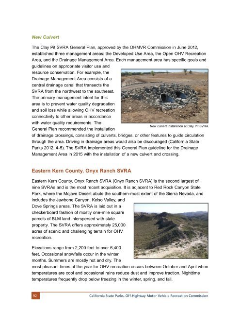
New Culvert<br />
The Clay Pit SVRA General Plan, approved by the OHMVR Commission in June 2012,<br />
established three management areas: the Developed Use Area, the Open OHV Recreation<br />
Area, and the Drainage Management Area. Each management area has specific goals and<br />
guidelines on appropriate visitor use and<br />
resource conservation. For example, the<br />
Drainage Management Area consists of a<br />
central drainage canal that transects the<br />
SVRA from the northwest to the southeast.<br />
The primary management intent for this<br />
area is to prevent water quality degradation<br />
and soil loss while allowing OHV recreation<br />
connectivity to other areas in accordance<br />
with water quality requirements. The<br />
General Plan recommended the installation<br />
New culvert installation at Clay Pit SVRA<br />
of drainage crossings, consisting of culverts, bridges, or other features to guide circulation<br />
through the area. Driving in drainage areas would also be discouraged (California State<br />
Parks 2012, 4-5). The SVRA implemented this General Plan guideline for the Drainage<br />
Management Area in 2015 with the installation of a new culvert and crossing.<br />
Eastern Kern County, Onyx Ranch SVRA<br />
Eastern Kern County, Onyx Ranch SVRA (Onyx Ranch SVRA) is the second largest of<br />
nine SVRAs and is the most recent acquisition. It is adjacent to Red Rock Canyon State<br />
Park, where the Mojave Desert abuts the southern-most extent of the Sierra Nevada, and<br />
includes the Jawbone Canyon, Kelso Valley, and<br />
Dove Springs areas. The SVRA is laid out in a<br />
checkerboard fashion of mostly one-mile square<br />
parcels of BLM land interspersed with state<br />
property. The SVRA offers approximately 25,000<br />
acres of scenic and challenging terrain for OHV<br />
recreation.<br />
Elevations range from 2,200 feet to over 6,400<br />
feet. Occasional snowfalls occur in the winter<br />
months. Summers are mostly hot and dry. The<br />
most pleasant times of the year for OHV recreation occurs between October and April when<br />
temperatures are cool and occasional rains reduce dust and improve traction. Nighttime<br />
temperatures frequently drop below freezing in the winter, spring, and fall.<br />
92<br />
California State Parks, Off-Highway Motor Vehicle Recreation Commission