

COMMISSION
4FcEkUnlA
4FcEkUnlA

Create successful ePaper yourself
Turn your PDF publications into a flip-book with our unique Google optimized e-Paper software.
Twelve sediment basins throughout the SVRA hold and store storm water and collect<br />
sediment before water continues through the hydrologic system. Prairie City SVRA uses<br />
sediment material collected from the basins for hillside restoration efforts.<br />
Hill Rotation Program<br />
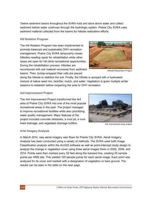
The Hill Rotation Program has been implemented to<br />
promote balanced and sustainable OHV recreation<br />
management. Prairie City SVRA temporarily closes<br />
hillsides needing repair for rehabilitation while other<br />
areas are open for hill climb recreational opportunities.<br />
During the rehabilitation process, hillsides are<br />
recontoured with soil material recovered from sediment<br />
basins. Then, burlap-wrapped fiber rolls are placed<br />
Hillside Restoration Project<br />
along the hillside to stabilize the soil. Finally, the hillside is sprayed with a hydroseed<br />
mixture of native seed mix, tackifier, mulch, and water. Vegetation is given multiple winter<br />
seasons to establish before reopening the area to OHV recreation.<br />
4x4 Improvement Project<br />
The 4x4 Improvement Project transformed the 4x4<br />
area of Prairie City SVRA into one of the most popular<br />
recreational areas in the park. The project managed<br />
to improve recreational facilities while also prioritizing<br />
water quality management. Major features of the<br />
project included concrete obstacles, a mud pit, a rocklined<br />
drainage, and vegetated drainage buffers.<br />
4x4 improvement area project<br />
Ariel Imagery Analysis<br />
In March 2014, new aerial imagery was flown for Prairie City SVRA. Aerial Imagery<br />
Analysis has been conducted using a variety of methods. The SVRA used both Image<br />
Classification analysis within the ArcGIS software as well as point-intercept study design to<br />
analyze the change in vegetation cover using three aerial images flown in 2002, 2009, and<br />
2014. Points were then marked every 50 feet along the transect line, creating 20 sample<br />
points per HMS site. This yielded 120 sample points for each aerial image. Each point was<br />
analyzed for its cover and marked with a designation of vegetation or bare ground. The<br />
results can be seen in the table on the next page.<br />
158<br />
California State Parks, Off-Highway Motor Vehicle Recreation Commission