

COMMISSION
4FcEkUnlA
4FcEkUnlA

You also want an ePaper? Increase the reach of your titles
YUMPU automatically turns print PDFs into web optimized ePapers that Google loves.
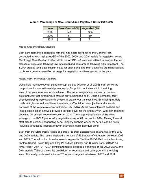
Table 1. Percentage of Bare Ground and Vegetated Cover 2002-2014<br />
Year Bare Ground (%) Vegetated (%)<br />
2002 27.5 72.5<br />
2009 41 59<br />
2014 29 71<br />
Image Classification Analysis<br />
Both park staff and a consulting firm that has been coordinating the General Plan,<br />
conducted analysis using ArcGIS of the 2002, 2009, and 2014 aerials for vegetation cover.<br />
The Image Classification toolbar within the ArcGIS software was utilized to analyze the land<br />
classes of vegetated (showing low reflection) and bare ground (showing high reflection). The<br />
SVRA created land classification maps for each aerial and then quantified the classifications<br />
to obtain a general quantified acreage for vegetation and bare ground in the park.<br />
Aerial Point-Intercept Analysis<br />
Using field methodology for point-intercept studies (Herrick et al. 2005), staff converted<br />
the protocol for use with aerial photography. Six point count sites within the riding<br />
area of the park were randomly selected. The aerial imagery was zoomed in on each<br />
point and 250-foot buffers were created surrounding the point. Using a compass, four<br />
directional points were randomly chosen to create four transect lines. By utilizing multiple<br />
methodologies as well as different analysts, staff obtained an objective and accurate<br />
portrayal of the vegetative cover at Prairie City SVRA. Aerial point-intercept analysis and<br />
image classification analysis provided percent cover for the entire SVRA, with both methods<br />
obtaining 70 percent vegetative cover for 2014. The image classification of the riding<br />
acreage of the SVRA produced a vegetative cover of 64 percent for 2014. Moving forward,<br />
staff plan to continue conducting aerial imagery analysis whenever aerials can be flown,<br />
including conducting vegetative cover analysis in each individual zone.<br />
Staff from the State Parks Roads and Trails Program assisted with an analysis of the 2002<br />
and 2009 aerials. The results depicted a net loss of 55.5 acres of vegetation between 2002<br />
and 2009. The full protocol can be seen in Appendix C of the 2013-2014 Habitat Monitoring<br />
System Report Prairie City and Clay Pit SVRAs (Heitner and Cumber-Lose, 2013/2014<br />
HMS Report 2014, 71-72). A consultant helped produce an analysis of the 2002, 2009, and<br />
2014 aerials. Table 2 shows the breakdown of vegetation and bare ground in the riding<br />
area. This analysis showed a loss of 26 acres of vegetation between 2002 and 2014.<br />
2017 Program Report 159