- Page 1 and 2: January 2017 Off-Highway Motor Vehi
- Page 3 and 4: California State Parks Mission Stat
- Page 5 and 6: Condition of Natural and Cultural R
- Page 7 and 8: Message from the Chair It is with g
- Page 9 and 10: OHMVR Division Vision Statement The
- Page 11 and 12: Introduction California is the nati
- Page 13 and 14: Program Goals The goals of the OHMV
- Page 15 and 16: OHMVR Commission The OHMVR Act esta
- Page 17 and 18: OHMVR Division The OHMVR Division o
- Page 19 and 20: Fuel Taxes Fuel taxes represent app
- Page 21 and 22: Economic Benefit Associated with OH
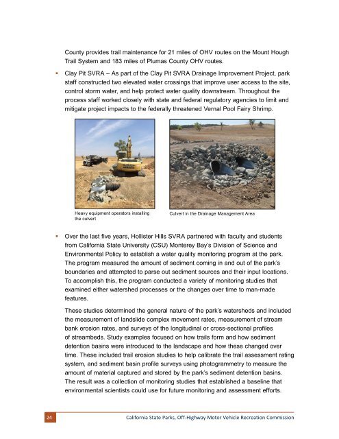
- Page 23 and 24: •§ California Air Resources Boar
- Page 25 and 26: 1990 1991 Prairie City SVRA General
- Page 27 and 28: GOAL 1 - Sustain Existing Opportuni
- Page 29 and 30: egard to their proposed project. Ap
- Page 31: •§ SVRA environmental scientists
- Page 35 and 36: y the United States Environmental P
- Page 37 and 38: •§ Hollister Hills SVRA is enter
- Page 39 and 40: Goal 2 Objectives Add new OHV oppor
- Page 41 and 42: national forests in the Region to p
- Page 43 and 44: participants to ask questions and d
- Page 45 and 46: members of the FTHL Interagency Coo
- Page 47 and 48: development opportunities have allo
- Page 49 and 50: •§ As part of the park’s storm
- Page 51 and 52: •§ As a strategy to reach teens,
- Page 53 and 54: OHMVR Division Outreach and Educati
- Page 55 and 56: Goal 5 Objectives Establish and mai
- Page 57 and 58: •§ OHMVR Division law enforcemen
- Page 59 and 60: about the importance of the Rubicon
- Page 61 and 62: drive enthusiasts watched in awe as
- Page 63 and 64: visitors without a 4x4 vehicle coul
- Page 65 and 66: Oceano Dunes Junior Lifeguard Progr
- Page 67 and 68: Youth Recreation Days On October 15
- Page 69 and 70: •§ Heber Dunes SVRA has an oral-
- Page 71 and 72: 6.2 By 2016, identify and obtain da
- Page 73 and 74: protecting current wildlife populat
- Page 75 and 76: Storm Water Management Plans A Stor
- Page 77 and 78: collaborate with many professional
- Page 79 and 80: Cultural Resource Program Conductin
- Page 81 and 82: Because of this evaluation, the ASC
- Page 83 and 84:
OHMVR Division archaeologists condu
- Page 85 and 86:
California Archaeological Site Stew
- Page 87 and 88:
Native American tribes also share t
- Page 89 and 90:
Resources Division offers annual tr
- Page 91 and 92:
Condition of Natural and Cultural R
- Page 93 and 94:
Public Education and Outreach with
- Page 95 and 96:
discharges from Carnegie SVRA throu
- Page 97 and 98:
To qualify for a specific treatment
- Page 99 and 100:
Bat Monitoring Program In 2014, a m
- Page 101 and 102:
New Culvert The Clay Pit SVRA Gener
- Page 103 and 104:
Law Enforcement San Andreas Distric
- Page 105 and 106:
Zone, for example, has guidelines t
- Page 107 and 108:
conducting a variety of monitoring
- Page 109 and 110:
The Hollister Hills SVRA’s fire p
- Page 111 and 112:
Vegetation within the park is diver
- Page 113 and 114:
The park’s unique riding substrat
- Page 115 and 116:
Air Quality Studies and Monitoring
- Page 117 and 118:
Permit (ITP) and associated Mitigat
- Page 119 and 120:
Sonoran Desert, desert ironwood (Ol
- Page 121 and 122:
Prairie City SVRA General Plan Upda
- Page 123 and 124:
Researchers in the biological scien
- Page 125 and 126:
2014 OHV Trail Workshop Highlights
- Page 127 and 128:
Popular 4-Wheel Drive Trail Reopens
- Page 129 and 130:
Kern County Sheriff’s Office Paci
- Page 131 and 132:
Iron Mountain SNO-Park Iron Mountai
- Page 133 and 134:
Report Requirement 3 The status and
- Page 135 and 136:
Farmworker Institute of Education a
- Page 137 and 138:
Partnerships Both the BLM and the U
- Page 139 and 140:
Project Amount Details Sierra Natio
- Page 141 and 142:
Project Amount Details American Riv
- Page 143 and 144:
Project Amount Details The Chaparra
- Page 145 and 146:
American badger, three owl species,
- Page 147 and 148:
Los Osos Knoll/Happiness Connection
- Page 149 and 150:
The limited sample size of four rid
- Page 151 and 152:
The Alamo River appeared to have po
- Page 153 and 154:
Back Field Obstacle Hill Climb Rest
- Page 155 and 156:
Hungry Valley SVRA Monitoring Progr
- Page 157 and 158:
planted native vegetation on the sl
- Page 159 and 160:
an ear tag. Ear tagging individuals
- Page 161 and 162:
In addition to periodic field monit
- Page 163 and 164:
data—historic and recent—will b
- Page 165 and 166:
site locations should be restricted
- Page 167 and 168:
Twelve sediment basins throughout t
- Page 169 and 170:
Table 2. Percentage of vegetation a
- Page 171 and 172:
OHMVR Division law enforcement team
- Page 173 and 174:
OHMVR Division Grants and Cooperati
- Page 175 and 176:
trespass on adjacent private lands.
- Page 177 and 178:
OHV activity on the trail. The surv
- Page 179 and 180:
evacuate local communities during d
- Page 181 and 182:
State Controller’s Office Divisio
- Page 183 and 184:
OHV routes are color coded specific
- Page 185 and 186:
Clear Creek Management Area The Cle
- Page 187 and 188:
assessment investigation. As in Apr
- Page 189 and 190:
is on BLM-administered lands. Thirt
- Page 191 and 192:
More recently, there have been effo
- Page 193 and 194:
4x4 play area and obstacle course,
- Page 195 and 196:
The new owners destroyed the town
- Page 197 and 198:
Park History The history of Clay Pi
- Page 199 and 200:
District manage the SVRA and hired
- Page 201 and 202:
The California gold rush brought Ar
- Page 203 and 204:
winding trails and paths, and inter
- Page 205 and 206:
In addition, there are many opportu
- Page 207 and 208:
Special Events: Areas within the pa
- Page 209 and 210:
Non-Motorized Recreation: Hollister
- Page 211 and 212:
Law enforcement staff patrol more t
- Page 213 and 214:
Three guest speakers from the park
- Page 215 and 216:
Hungry Valley SVRA Hungry Valley SV
- Page 217 and 218:
Hiking in the Oak Preserve: The Oak
- Page 219 and 220:
Interpretive panels are under devel
- Page 221 and 222:
Day Use and Camping: The park offer
- Page 223 and 224:
Staff, volunteers, and docents also
- Page 225 and 226:
Ocotillo Wells SVRA Ocotillo Wells
- Page 227 and 228:
push the extremes of their vehicle
- Page 229 and 230:
Shell Reef: Park beneath the reef a
- Page 231 and 232:
Kid’s Adventure Connection Each w
- Page 233 and 234:
Environmental Training Center: The
- Page 235 and 236:
Mountain Biking: On Wednesday eveni
- Page 237 and 238:
Works Cited Beaupré, K et al. Land
- Page 239 and 240:
Heitner, Max, and Lora Elsom. 2015
- Page 241 and 242:
Glossary of Terms and Abbreviations
- Page 243 and 244:
NCCP Natural Community Conservation
- Page 245 and 246:
OHMVR COMMISSIONERS TERMS OF OFFICE
- Page 247 and 248:
Assembly - #1 Willie Brown John Mot