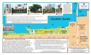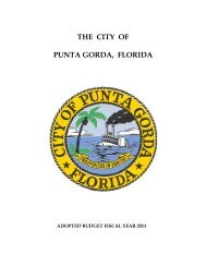
Chapter 26 - City of Punta Gorda
Chapter 26 - City of Punta Gorda
Chapter 26 - City of Punta Gorda

Create successful ePaper yourself
Turn your PDF publications into a flip-book with our unique Google optimized e-Paper software.
park, and roadway capacities needed to meet the needs <strong>of</strong> the approved project<br />
for the same one-year period.<br />
(b) Plan Submission and Review. Any development plan required to be submitted<br />
under the provisions <strong>of</strong> this ordinance shall include the following elements,<br />
unless the Zoning Official determines that one or more <strong>of</strong> said elements does<br />
not apply to the particular development:<br />
(1) Statement <strong>of</strong> ownership and control <strong>of</strong> the proposed development.<br />
(2) Statement describing in detail the character and intended use <strong>of</strong> the<br />
development.<br />
(3) General location maps showing relation <strong>of</strong> the site for which development<br />
plan approval is sought to major streets, schools, existing utilities,<br />
shopping areas, important physical features in and adjoining the projects<br />
site, and the like.<br />
(4) If common facilities, such as recreation areas or structures, private<br />
streets, common open space, etc., are to be provided, statements as to<br />
how such facilities are to be permanently maintained. Such statements<br />
may take the form <strong>of</strong> proposed deed restrictions, deeds <strong>of</strong> trust,<br />
homeowners association, surety arrangements, or other legal instruments<br />
providing adequate guarantees to the <strong>City</strong> that such common facilities<br />
will not become a future liability <strong>of</strong> the <strong>City</strong>.<br />
(5) Storm drainage and sanitary sewage plans.<br />
(6) Architectural definitions for buildings in the development; exact number<br />
<strong>of</strong> dwelling units, sizes and types.<br />
(7) Plans for signs, if any.<br />
(8) Landscaping plan, including types, sizes and locations <strong>of</strong> vegetation and<br />
decorative shrubbery, and showing provisions for irrigation and<br />
maintenance.<br />
(9) Plans for recreation facilities, marinas, docking facilities, both accessory<br />
and principally permitted uses, and any buildings and/or structures<br />
related to such uses.<br />
(10) The location and proposed use <strong>of</strong> any historic structures or artifacts as<br />
defined by the <strong>City</strong> historic preservation ordinance.<br />
(11) A written natural resources impact statement disclosing any land use<br />
activities proposed for the site which might degrade local air or water<br />
quality, alter any existing wetlands or designated environmentally<br />
sensitive areas, involve any mining or excavation, disturb or destroy<br />
existing wildlife habitats, and affect in any way a threatened or<br />
endangered plant or animal.<br />
(12) Additional data, maps, plans, surveys or statements as may be required<br />
for the particular use or activity involved.<br />
(13) Any additional data the applicant may believe is pertinent to the<br />
development plan.<br />
(14) A development plan containing the title <strong>of</strong> the project and the names <strong>of</strong><br />
the project planner and developer, date, and north arrow, and based on<br />
an exact survey <strong>of</strong> the property drawn to a scale <strong>of</strong> sufficient size to<br />
show:<br />
a. Boundaries <strong>of</strong> the project, any existing streets, buildings,<br />
watercourses, natural features, vegetation and topography,<br />
easements, and section lines;<br />
b. Exact location <strong>of</strong> all buildings and structures;<br />
c. Access and traffic flow and how vehicular traffic will be separated<br />
from pedestrian and other types <strong>of</strong> traffic;<br />
<strong>26</strong>-186