

Draft Environmental Impact Report - California Off Highway Vehicle ...
Draft Environmental Impact Report - California Off Highway Vehicle ...
Draft Environmental Impact Report - California Off Highway Vehicle ...

You also want an ePaper? Increase the reach of your titles
YUMPU automatically turns print PDFs into web optimized ePapers that Google loves.
4.0 Cumulative Analysis<br />
future analysis date is appropriate and conservative, as it accounts for projected increases in<br />
traffic on local roadways.<br />
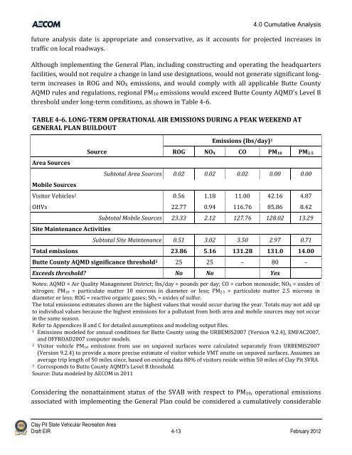
Although implementing the General Plan, including constructing and operating the headquarters<br />
facilities, would not require a change in land use designations, would not generate significant long‐<br />
term increases in ROG and NOX emissions, and would comply with all applicable Butte County<br />
AQMD rules and regulations, regional PM10 emissions would exceed Butte County AQMD’s Level B<br />
threshold under long‐term conditions, as shown in Table 4‐6.<br />
TABLE 46. LONGTERM OPERATIONAL AIR EMISSIONS DURING A PEAK WEEKEND AT<br />
GENERAL PLAN BUILDOUT<br />
Area Sources<br />
Mobile Sources<br />
Source<br />
Emissions (lbs/day) 1<br />
ROG NOX CO PM10 PM2.5<br />
Subtotal Area Sources 0.02 0.02 0.02 0.00 0.00<br />
Visitor <strong>Vehicle</strong>s 2 0.56 1.18 11.00 42.16 4.87<br />
OHVs 22.77 0.94 116.76 85.86 8.42<br />
Site Maintenance Activities<br />
Subtotal Mobile Sources 23.33 2.12 127.76 128.02 13.29<br />
Subtotal Site Maintenance 0.51 3.02 3.50 2.97 0.71<br />
Total emissions 23.86 5.16 131.28 131.0 14.00<br />
Butte County AQMD significance threshold 3 25 25 – 80 –<br />
Exceeds threshold? No No Yes<br />
Notes: AQMD = Air Quality Management District; lbs/day = pounds per day; CO = carbon monoxide; NOX = oxides of<br />
nitrogen; PM10 = particulate matter 10 microns in diameter or less; PM2.5 = particulate matter 2.5 microns in<br />
diameter or less; ROG = reactive organic gases; SOX = oxides of sulfur.<br />
The total emissions estimates shown are the highest values that would occur during the year. Totals may not add up<br />
to individual values because the highest emissions for a pollutant from both area and mobile sources may not occur<br />
in the same season.<br />
Refer to Appendices B and C for detailed assumptions and modeling output files.<br />
1 Emissions modeled for annual conditions for Butte County using the URBEMIS2007 (Version 9.2.4), EMFAC2007,<br />
and OFFROAD2007 computer models.<br />
2 Visitor vehicle PM10 emissions from use on unpaved surfaces were calculated separately from URBEMIS2007<br />
(Version 9.2.4) to provide a more precise estimate of visitor vehicle VMT onsite on unpaved surfaces. Assumes an<br />
average trip length of 50 miles since, based on existing data 80% of visitors reside within 50 miles of Clay Pit SVRA.<br />
3 Corresponds to Butte County AQMD’s Level B threshold.<br />
Source: Data modeled by AECOM in 2011<br />
Considering the nonattainment status of the SVAB with respect to PM10, operational emissions<br />
associated with implementing the General Plan could be considered a cumulatively considerable<br />
Clay Pit State Vehicular Recreation Area<br />
<strong>Draft</strong> EIR 4-13 February 2012


