- Page 1 and 2:
STATE VEHICULAR RECREATION AREA Dra
- Page 3 and 4:
CALIFORNIA STATE PARKS Draft Enviro
- Page 5 and 6:
TABLE OF CONTENTS Table of Contents
- Page 7 and 8:
TABLE OF CONTENTS Table of Contents
- Page 9 and 10:
TABLE OF CONTENTS Table of Contents
- Page 11 and 12: LIST OF ACRONYMS μg/l micrograms p
- Page 13 and 14: Lmax maximum noise level Ln statist
- Page 15 and 16: VELB valley elderberry longhorn bee
- Page 17 and 18: Chapter S.0 - Summary S.0 Summary T
- Page 19 and 20: S.0 Summary No mitigation measures
- Page 21 and 22: Chapter 1.0 - Introduction 1.0 Intr
- Page 23 and 24: Source: Adapted by AECOM 2011 1.0 I
- Page 25 and 26: State Parks, California Department
- Page 27 and 28: Safety proximity to California Dep
- Page 29 and 30: 1.7 DEIR Contents and Organization
- Page 31 and 32: Chapter 2.0 - Project Description 2
- Page 33 and 34: Source: AECOM 2011 2.0 Project Desc
- Page 35 and 36: 2.0 Project Description The OHMVR D
- Page 37 and 38: 2.0 Project Description the signifi
- Page 39 and 40: Natural Resources Management (NRM)
- Page 41 and 42: Open OHV Recreation Area 2.0 Projec
- Page 43 and 44: TABLE 21. USE AREA MATRIX TOPICS
- Page 45 and 46: Source: Topographic information pro
- Page 47 and 48: Chapter 3.0 - Environmental Analysi
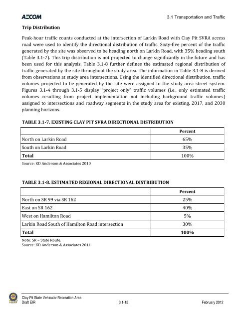
- Page 49 and 50: 3.1 Transportation and Traffic 3.1
- Page 51 and 52: 3.1 Transportation and Traffic cont
- Page 53 and 54: Source: KD Anderson & Associates 20
- Page 55 and 56: TABLE 3.11. DEFINITION OF LEVEL O
- Page 57 and 58: TABLE 3.13. EXISTING ROADWAY LEVE
- Page 59 and 60: 3.1 Transportation and Traffic A tr
- Page 61: TABLE 3.14. PEAKHOUR LOS VOLUME
- Page 65 and 66: Source: KD Anderson & Associates 20
- Page 67 and 68: 3.1 Transportation and Traffic TABL
- Page 69 and 70: Source: KD Anderson & Associates 20
- Page 71 and 72: 3.1 Transportation and Traffic Othe
- Page 73 and 74: Source: KD Anderson & Associates 20
- Page 75 and 76: Source: KD Anderson & Associates 20
- Page 77 and 78: Clay Pit State Vehicular Recreation
- Page 79 and 80: 3.1.5 Summary of Significant Impact
- Page 81 and 82: 3.2 Air Quality 3.2 Air Quality Thi
- Page 83 and 84: 3.2 Air Quality During this 3‐yea
- Page 85 and 86: 3.2 Air Quality geographic barriers
- Page 87 and 88: 3.2 Air Quality Rule 205, “Fugit
- Page 89 and 90: 3.2 Air Quality URBEMIS2007 also in
- Page 91 and 92: 3.2 Air Quality Substitute electri
- Page 93 and 94: 3.2 Air Quality Implementation of t
- Page 95 and 96: 3.2 Air Quality Fugitive Dust All f
- Page 97 and 98: 3.2 Air Quality the project area, t
- Page 99 and 100: 3.2.6 Mitigation Measures 3.2 Air Q
- Page 101 and 102: 3.3 Noise 3.3 Noise This section pr
- Page 103 and 104: 3.3 Noise the way humans perceive s
- Page 105 and 106: 3.3 Noise nonauditory health effect
- Page 107 and 108: 3.3 Noise Vegetation can be used to
- Page 109 and 110: Source: Data collected by AECOM in
- Page 111 and 112: 3.3 Noise Table 3.3‐2 summarizes
- Page 113 and 114:
Source: City of Oroville 1990 3.3 N
- Page 115 and 116:
3.3 Noise existing or proposed noi
- Page 117 and 118:
General Plan Impact Analysis IMPACT
- Page 119 and 120:
3.3 Noise The extent to which noise
- Page 121 and 122:
3.3 Noise equipment. Noise levels f
- Page 123 and 124:
3.3 Noise the headquarters faciliti
- Page 125 and 126:
3.4 Visual Resources 3.4 Visual Res
- Page 127 and 128:
3.4 Visual Resources resource ident
- Page 129 and 130:
3.4 Visual Resources scenic vistas
- Page 131 and 132:
3.4.6 Mitigation Measures 3.4 Visua
- Page 133 and 134:
3.5 Biological Resources 3.5 Biolog
- Page 135 and 136:
Source: TRA 2004, 2007, 2008, AECOM
- Page 137 and 138:
3.5 Biological Resources An AECOM b
- Page 139 and 140:
Source: CNDDB April 2011 3.5 Biolog
- Page 141 and 142:
3.5 Biological Resources The annual
- Page 143 and 144:
3.5 Biological Resources Central Va
- Page 145 and 146:
3.5 Biological Resources Plan conta
- Page 147 and 148:
3.5 Biological Resources or during
- Page 149 and 150:
3.6 Cultural Resources 3.6 Cultural
- Page 151 and 152:
California Public Resource Code 3.6
- Page 153 and 154:
Section 7050.5 Section 7050.5 inclu
- Page 155 and 156:
3.6 Cultural Resources directly or
- Page 157 and 158:
Mitigation Measures: No mitigation
- Page 159 and 160:
3.7 Geology and Soils 3.7 Geology a
- Page 161 and 162:
3.7 Geology and Soils a designated
- Page 163 and 164:
3.7 Geology and Soils 19, On‐Site
- Page 165 and 166:
3.7 Geology and Soils constructed i
- Page 167 and 168:
3.7 Geology and Soils As noted unde
- Page 169 and 170:
3.8 Hydrology and Water Quality 3.8
- Page 171 and 172:
State Plans, Policies, Regulations,
- Page 173 and 174:
3.8 Hydrology and Water Quality to
- Page 175 and 176:
3.8 Hydrology and Water Quality Im
- Page 177 and 178:
3.8 Hydrology and Water Quality dra
- Page 179 and 180:
3.8 Hydrology and Water Quality DMA
- Page 181 and 182:
3.8 Hydrology and Water Quality So
- Page 183 and 184:
3.8 Hydrology and Water Quality IE
- Page 185 and 186:
3.8 Hydrology and Water Quality Bec
- Page 187 and 188:
3.9 Public Services and Utilities 3
- Page 189 and 190:
3.9.2 Regulatory Setting 3.9 Public
- Page 191 and 192:
3.9 Public Services and Utilities I
- Page 193 and 194:
3.9 Public Services and Utilities r
- Page 195 and 196:
IMPACT 3.9-4 Risk of Exceeding Wast
- Page 197 and 198:
3.10 Hazards and Hazardous Material
- Page 199 and 200:
Federal Plans, Policies, Regulation
- Page 201 and 202:
Regional Plans, Policies, Regulatio
- Page 203 and 204:
General Plan Impact Analysis IMPACT
- Page 205 and 206:
3.10 Hazards and Hazardous Material
- Page 207 and 208:
3.11 Climate Change 3.11 Climate Ch
- Page 209 and 210:
3.11 Climate Change New developmen
- Page 211 and 212:
3.11 Climate Change This informatio
- Page 213 and 214:
3.11 Climate Change increased atten
- Page 215 and 216:
Headquarters Facilities Impact Anal
- Page 217 and 218:
Chapter 4.0 - Cumulative Analysis 4
- Page 219 and 220:
4.0 Cumulative Analysis extend far
- Page 221 and 222:
TABLE 43. CUMULATIVE PROJECTS Pro
- Page 223 and 224:
4.0 Cumulative Analysis Year 2030 P
- Page 225 and 226:
4.0 Cumulative Analysis display the
- Page 227 and 228:
Clay Pit State Vehicular Recreation
- Page 229 and 230:
4.0 Cumulative Analysis future anal
- Page 231 and 232:
4.0 Cumulative Analysis generated b
- Page 233 and 234:
4.0 Cumulative Analysis The potenti
- Page 235 and 236:
4.0 Cumulative Analysis required to
- Page 237 and 238:
Chapter 5.0 - Other CEQA-Required A
- Page 239 and 240:
5.0 Other CEQA Required Analysis an
- Page 241 and 242:
Chapter 6.0 - Alternatives to the P
- Page 243 and 244:
Source: AECOM 2010 6.0 Alternatives
- Page 245 and 246:
6.0 Alternatives to the Proposed Ac
- Page 247 and 248:
6.0 Alternatives to the Proposed Ac
- Page 249 and 250:
Chapter 7.0 - References Summary St
- Page 251 and 252:
7.0 References Kamian, Armen. Assoc
- Page 253 and 254:
7.0 References Ecologist, Off‐Hig
- Page 255 and 256:
7.0 References California Departmen
- Page 257 and 258:
7.0 References CalRecycle. 2010. Fa
- Page 259 and 260:
7.0 References City of Oroville. 20
- Page 261 and 262:
Chapter 8.0 - Report Contributors 8