

Draft Environmental Impact Report - California Off Highway Vehicle ...
Draft Environmental Impact Report - California Off Highway Vehicle ...
Draft Environmental Impact Report - California Off Highway Vehicle ...

You also want an ePaper? Increase the reach of your titles
YUMPU automatically turns print PDFs into web optimized ePapers that Google loves.
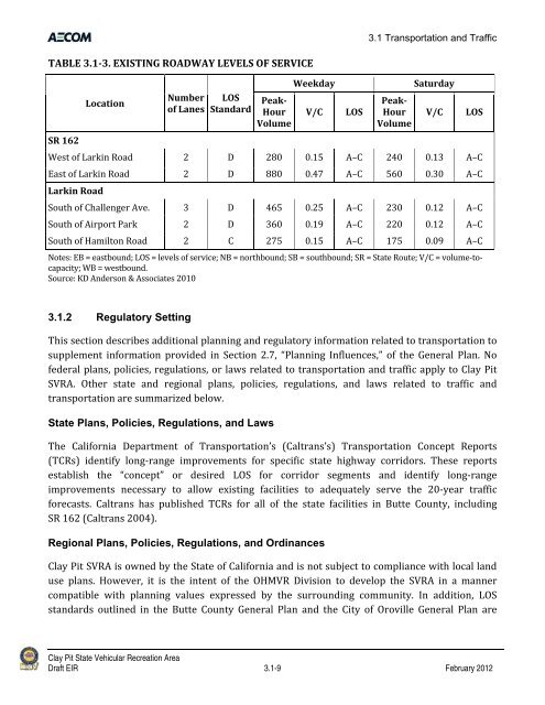
TABLE 3.13. EXISTING ROADWAY LEVELS OF SERVICE<br />
SR 162<br />
Location<br />
Number<br />
of Lanes<br />
LOS<br />
Standard<br />
Peak<br />
Hour<br />
Volume<br />
3.1 Transportation and Traffic<br />
Weekday Saturday<br />
V/C LOS<br />
Peak<br />
Hour<br />
Volume<br />
V/C LOS<br />
West of Larkin Road 2 D 280 0.15 A–C 240 0.13 A–C<br />
East of Larkin Road 2 D 880 0.47 A–C 560 0.30 A–C<br />
Larkin Road<br />
South of Challenger Ave. 3 D 465 0.25 A–C 230 0.12 A–C<br />
South of Airport Park 2 D 360 0.19 A–C 220 0.12 A–C<br />
South of Hamilton Road 2 C 275 0.15 A–C 175 0.09 A–C<br />
Notes: EB = eastbound; LOS = levels of service; NB = northbound; SB = southbound; SR = State Route; V/C = volume‐to‐<br />
capacity; WB = westbound.<br />
Source: KD Anderson & Associates 2010<br />
3.1.2 Regulatory Setting<br />
This section describes additional planning and regulatory information related to transportation to<br />
supplement information provided in Section 2.7, “Planning Influences,” of the General Plan. No<br />
federal plans, policies, regulations, or laws related to transportation and traffic apply to Clay Pit<br />
SVRA. Other state and regional plans, policies, regulations, and laws related to traffic and<br />
transportation are summarized below.<br />
State Plans, Policies, Regulations, and Laws<br />
The <strong>California</strong> Department of Transportation’s (Caltrans’s) Transportation Concept <strong>Report</strong>s<br />
(TCRs) identify long‐range improvements for specific state highway corridors. These reports<br />
establish the “concept” or desired LOS for corridor segments and identify long‐range<br />
improvements necessary to allow existing facilities to adequately serve the 20‐year traffic<br />
forecasts. Caltrans has published TCRs for all of the state facilities in Butte County, including<br />
SR 162 (Caltrans 2004).<br />
Regional Plans, Policies, Regulations, and Ordinances<br />
Clay Pit SVRA is owned by the State of <strong>California</strong> and is not subject to compliance with local land<br />
use plans. However, it is the intent of the OHMVR Division to develop the SVRA in a manner<br />
compatible with planning values expressed by the surrounding community. In addition, LOS<br />
standards outlined in the Butte County General Plan and the City of Oroville General Plan are<br />
Clay Pit State Vehicular Recreation Area<br />
<strong>Draft</strong> EIR 3.1-9 February 2012


