

Draft Environmental Impact Report - California Off Highway Vehicle ...
Draft Environmental Impact Report - California Off Highway Vehicle ...
Draft Environmental Impact Report - California Off Highway Vehicle ...

Create successful ePaper yourself
Turn your PDF publications into a flip-book with our unique Google optimized e-Paper software.
3.2 Air Quality<br />
may otherwise drive outside the area to other OHV recreation facilities, or who may operate OHVs<br />
in non‐designated areas in the county. No other SVRAs are located within 80 miles of Clay Pit<br />
SVRA and 4x4 recreationists routinely drive over 100 miles to reach recreation areas outside of<br />
Butte County. By offering new on‐site facilities such as a 4x4 obstacle course and motorcycle<br />
tracks, local user groups would be less likely to drive as far to participate in these activities, thus<br />
reducing potential vehicle emissions.<br />
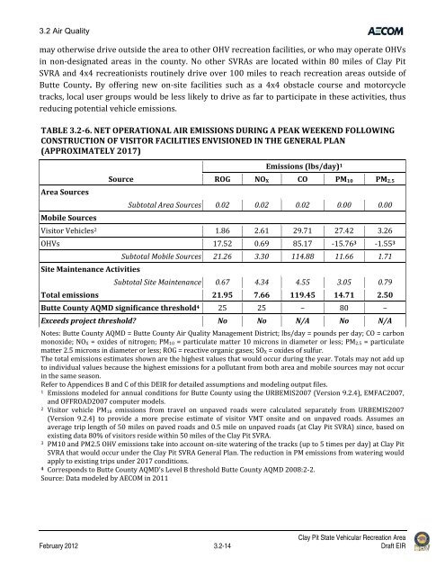
TABLE 3.26. NET OPERATIONAL AIR EMISSIONS DURING A PEAK WEEKEND FOLLOWING<br />
CONSTRUCTION OF VISITOR FACILITIES ENVISIONED IN THE GENERAL PLAN<br />
(APPROXIMATELY 2017)<br />
Area Sources<br />
Mobile Sources<br />
Source<br />
Emissions (lbs/day) 1<br />
ROG NOX CO PM10 PM2.5<br />
Subtotal Area Sources 0.02 0.02 0.02 0.00 0.00<br />
Visitor <strong>Vehicle</strong>s 2 1.86 2.61 29.71 27.42 3.26<br />
OHVs 17.52 0.69 85.17 ‐15.76 3 ‐1.55 3<br />
Site Maintenance Activities<br />
Subtotal Mobile Sources 21.26 3.30 114.88 11.66 1.71<br />
Subtotal Site Maintenance 0.67 4.34 4.55 3.05 0.79<br />
Total emissions 21.95 7.66 119.45 14.71 2.50<br />
Butte County AQMD significance threshold 4 25 25 – 80 –<br />
Exceeds project threshold? No No N/A No N/A<br />
Notes: Butte County AQMD = Butte County Air Quality Management District; lbs/day = pounds per day; CO = carbon<br />
monoxide; NOX = oxides of nitrogen; PM10 = particulate matter 10 microns in diameter or less; PM2.5 = particulate<br />
matter 2.5 microns in diameter or less; ROG = reactive organic gases; SOX = oxides of sulfur.<br />
The total emissions estimates shown are the highest values that would occur during the year. Totals may not add up<br />
to individual values because the highest emissions for a pollutant from both area and mobile sources may not occur<br />
in the same season.<br />
Refer to Appendices B and C of this DEIR for detailed assumptions and modeling output files.<br />
1 Emissions modeled for annual conditions for Butte County using the URBEMIS2007 (Version 9.2.4), EMFAC2007,<br />
and OFFROAD2007 computer models.<br />
2 Visitor vehicle PM10 emissions from travel on unpaved roads were calculated separately from URBEMIS2007<br />
(Version 9.2.4) to provide a more precise estimate of visitor VMT onsite and on unpaved roads. Assumes an<br />
average trip length of 50 miles on paved roads and 0.5 mile on unpaved roads (at Clay Pit SVRA) since, based on<br />
existing data 80% of visitors reside within 50 miles of the Clay Pit SVRA.<br />
3 PM10 and PM2.5 OHV emissions take into account on‐site watering of the tracks (up to 5 times per day) at Clay Pit<br />
SVRA that would occur under the Clay Pit SVRA General Plan. The reduction in PM emissions from watering would<br />
apply to existing trips under 2017 conditions.<br />
4 Corresponds to Butte County AQMD’s Level B threshold Butte County AQMD 2008:2‐2.<br />
Source: Data modeled by AECOM in 2011<br />
Clay Pit State Vehicular Recreation Area<br />
February 2012 3.2-14 <strong>Draft</strong> EIR


