

Draft Environmental Impact Report - California Off Highway Vehicle ...
Draft Environmental Impact Report - California Off Highway Vehicle ...
Draft Environmental Impact Report - California Off Highway Vehicle ...

You also want an ePaper? Increase the reach of your titles
YUMPU automatically turns print PDFs into web optimized ePapers that Google loves.
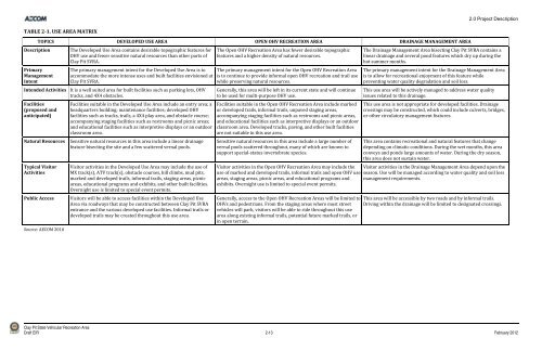
TABLE 21. USE AREA MATRIX<br />
TOPICS DEVELOPED USE AREA OPEN OHV RECREATION AREA DRAINAGE MANAGEMENT AREA<br />
Description The Developed Use Area contains desirable topographic features for<br />
OHV use and fewer sensitive natural resources than other parts of<br />
Clay Pit SVRA.<br />
Primary<br />
Management<br />
Intent<br />
The primary management intent for the Developed Use Area is to<br />
accommodate the more intense uses and built facilities envisioned at<br />
Clay Pit SVRA.<br />
Intended Activities It is a well suited area for built facilities such as parking lots, OHV<br />
tracks, and 4X4 obstacles.<br />
Facilities<br />
(proposed and<br />
anticipated)<br />
Facilities suitable in the Developed Use Area include an entry area; a<br />
headquarters building; maintenance facilities; developed OHV<br />
facilities such as tracks, trails, a 4X4 play area, and obstacle course;<br />
accompanying staging facilities such as restrooms and picnic areas;<br />
and educational facilities such as interpretive displays or an outdoor<br />
classroom area.<br />
Natural Resources Sensitive natural resources in this area include a linear drainage<br />
feature bisecting the site and a few scattered vernal pools.<br />
Typical Visitor<br />
Activities<br />
Visitor activities in the Developed Use Area may include the use of<br />
MX track(s), ATV track(s), obstacle courses, hill climbs, mud pits,<br />
marked and developed trails, informal trails, staging areas, picnic<br />
areas, educational programs and exhibits, and other built facilities.<br />
Overnight use is limited to special event permits.<br />
Public Access Visitors will be able to access facilities within the Developed Use<br />
Area via roadways that may be constructed between Clay Pit SVRA<br />
entrance and the various developed use facilities. Informal trails or<br />
developed trails may be created throughout this use area.<br />
Source: AECOM 2010<br />
The Open OHV Recreation Area has fewer desirable topographic<br />
features and a higher density of natural resources.<br />
The primary management intent for the Open OHV Recreation Area<br />
is to continue to provide informal open OHV recreation and trail use<br />
while preserving natural resources.<br />
Generally, this area will be left in its current state and will continue<br />
to be used for multi‐purpose OHV use.<br />
Facilities suitable in the Open OHV Recreation Area include marked<br />
or developed trails, informal trails, unpaved staging areas,<br />
accompanying staging facilities such as restrooms and picnic areas,<br />
and educational facilities such as interpretive displays or an outdoor<br />
classroom area. Developed tracks, paving, and other built facilities<br />
are not suitable in this use area.<br />
Sensitive natural resources in this area include a large number of<br />
vernal pools scattered throughout, many of which are known to<br />
support special‐status invertebrate species.<br />
Visitor activities in the Open OHV Recreation Area may include the<br />
use of marked and developed trails, informal trails and open OHV use<br />
areas, staging areas, picnic areas, and educational programs and<br />
exhibits. Overnight use is limited to special event permits.<br />
Generally, access to the Open OHV Recreation Areas will be limited to<br />
OHVs and pedestrians. From the staging areas where most street<br />
vehicles will park, visitors will be able to ride throughout this use<br />
area along existing informal trails, potential future marked trails, or<br />
in open terrain.<br />
2.0 Project Description<br />
The Drainage Management Area bisecting Clay Pit SVRA contains a<br />
linear drainage and several pond features which dry up during the<br />
hot summer months.<br />
The primary management intent for the Drainage Management Area<br />
is to allow for recreational enjoyment of this feature while<br />
preventing water quality degradation and soil loss.<br />
This use area will be actively managed to address water quality<br />
issues related to this drainage.<br />
This use area is not appropriate for developed facilities. Drainage<br />
crossings may be constructed, which could include culverts, bridges,<br />
or other circulatory management features.<br />
This area contains recreational and natural features that change<br />
depending on climatic conditions. During the wet months, this area<br />
conveys and ponds large amounts of water. During the dry season,<br />
this area does not sustain water.<br />
Visitor activities in the Drainage Management Area depend upon the<br />
season. Use will be managed according to water quality and soil loss<br />
management requirements.<br />
This area will be accessible by two roads and by informal trails.<br />
Driving within the drainage will be limited to designated crossings.<br />
Clay Pit State Vehicular Recreation Area<br />
<strong>Draft</strong> EIR 2-13 February 2012


