- Page 1 and 2: Statistical Abstract of the United
- Page 3 and 4: Preface The S tatistical A b stract
- Page 5 and 6: C o n ten ts [Numbers following sub
- Page 7 and 8: Contents Sec. 11. SOCIAL INSURANCE
- Page 9 and 10: Contents xi Page Sec. 22. TRANSPORT
- Page 11 and 12: Contents xiii Page Sec. 33. COMPARA
- Page 13 and 14: Guide to Tabular Presentation XV Th
- Page 15 and 16: Recent Trends Population Rasident P
- Page 17 and 18: Recent Trends XIX V ital Statistics
- Page 19 and 20: Recent Trends xxi Labor Force and I
- Page 21 and 22: Recent Trends xxiii Government, Def
- Page 23 and 24: Recent Trends xxv Business and Fina
- Page 25 and 26: Recent Trends xxvii Science, Commun
- Page 27: 1982 Election Results xxix th is sp
- Page 31 and 32: xxxii 1982 Election Results T a b l
- Page 33 and 34: X X X IV 1982 Election Results T a
- Page 35 and 36: 2 Population tional Population by A
- Page 37 and 38: 4 Population In the 1980 and 1981 C
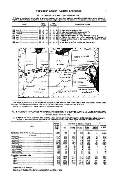
- Page 39: 6 Population No. 1. P o p u l a t i
- Page 43 and 44: 10 Population No. 10. Resident Popu
- Page 45 and 46: 12 Population No. 1 1 . R e s id e
- Page 47 and 48: 14 Population No. 13. Interregional
- Page 49 and 50: 16 Population No. 19. M e t r o p o
- Page 51 and 52: 1 8 Population N o . 2 0 . L a r g
- Page 53 and 54: 20 Population No. 21. P o p u l a t
- Page 55 and 56: 2 2 Population NO: 26. Cities W ith
- Page 57 and 58: 2 4 Population No. 26. C i t i e s
- Page 60 and 61: 2 6 Population N o . 2 8 . P o p u
- Page 63 and 64: 28 Population No. 32. R e s id e n
- Page 65 and 66: 30 Population No. 33. R e s id e n
- Page 67 and 68: 32 Population No. 36. Resident Popu
- Page 69 and 70: 3 4 Population N o . 3 9 . P o p u
- Page 71 and 72: 36 Population No. 42. Population, b
- Page 73 and 74: 38 Population No. 46. C u r r e n t
- Page 75 and 76: 4 0 Population No. 50. E v e r - M
- Page 77 and 78: 4 2 Population No. 55. Interracial
- Page 79 and 80: 4 4 Population No. 61. Households,
- Page 81 and 82: 4 6 Population No. 65. H o u s e h
- Page 83 and 84: 4 8 Population N o . 6 8 . H o u s
- Page 85 and 86: 50 Population No. 7 1 . F a m ilie
- Page 87 and 88: 52 Population N o . 7 6 . C h il d
- Page 89 and 90: 54 Population No. 80. R eligious Bo
- Page 91 and 92:
56 Population No. 8 2 . R e li g io
- Page 93 and 94:
5 8 Vital Statistics Fertility and
- Page 95 and 96:
60 Vital Statistics No. 84. L iv e
- Page 97 and 98:
62 V ita l Statistics N o . S8. Liv
- Page 99 and 100:
64 Vital Statistics No. 9A. Social
- Page 101 and 102:
66 Vital Statistics No. 9 6 . P e r
- Page 103 and 104:
Vital Statistics NO. 100. CONTRACEP
- Page 105 and 106:
70 Vital Statistics No. 104. Legal
- Page 107 and 108:
72 Vital Statistics No. 107. E x p
- Page 109 and 110:
74 Vital Statistics No. 110. D e a
- Page 111 and 112:
76 Vital Statistics No. 113. Death
- Page 113 and 114:
78 Vital Statistics No. 115. Deaths
- Page 115 and 116:
80 Vital Statistics No. 119. Deaths
- Page 117 and 118:
8 2 Vital Statistics No. 124. M a r
- Page 119 and 120:
8 4 Vital Statistics No. 1 2 7 . D
- Page 121 and 122:
86 Immigration and Naturalization T
- Page 124 and 125:
88 Immigration and Naturalization N
- Page 126 and 127:
90 Immigration and Naturalization N
- Page 128 and 129:
92 Immigration and Naturalization N
- Page 130 and 131:
94 Immigration and Naturalization N
- Page 132 and 133:
96 Immigration and Naturalization N
- Page 134 and 135:
98 Health and Nutrition Figure 4.1
- Page 136 and 137:
100 Health and Nutrition Health res
- Page 138 and 139:
102 Health and Nutrition No. 1 5 1
- Page 140 and 141:
104 Health and Nutrition No. 154. G
- Page 142 and 143:
106 Health and Nutrition No. 1 6 0
- Page 144 and 145:
108 Health and Nutrition N O . 163.
- Page 146 and 147:
110 Health and Nutrition No. 168. V
- Page 148 and 149:
112 Health and Nutrition No. 173. H
- Page 150 and 151:
1 1 4 Health and Nutrition No. 176.
- Page 152 and 153:
116 Health and Nutrition No, 179. H
- Page 154 and 155:
1 1 8 Health and Nutrition No. 184.
- Page 156 and 157:
120 Health and Nutrition No. 187. P
- Page 158 and 159:
122 Health and Nutrition N o . 1 9
- Page 160 and 161:
1 2 4 Health and Nutrition No. 197.
- Page 162 and 163:
1 2 6 Health and Nutrition No. 201.
- Page 164 and 165:
128 Health and Nutrition No. 204. N
- Page 166 and 167:
130 Health and Nutrition No. 208. F
- Page 168 and 169:
132 Education Regular schools are t
- Page 170 and 171:
134 Education No. 211. P u b lic an
- Page 172 and 173:
136 Education N o . 2 1 4 . S c h o
- Page 174 and 175:
138 Education N o . 2 1 7 . E n r o
- Page 176 and 177:
140 Education I960, total1. 3 and 4
- Page 178 and 179:
H 2 Education No. 223. Preprimary S
- Page 180 and 181:
144 Education No. 227. Y ears o f S
- Page 182 and 183:
1 4 6 Education No. 231. M e d ia n
- Page 184 and 185:
1 4 8 Education No. 235. Public Ele
- Page 186 and 187:
150 Education No. 240. Mode o f Tra
- Page 188 and 189:
152 Education No. 245. Pu b l ic El
- Page 190 and 191:
1 5 4 Education No. 2 4 9 . P u b l
- Page 192 and 193:
156 Education No. 252. P u b lic E
- Page 194 and 195:
158 Education No. 2 5 6 . H ig h S
- Page 196 and 197:
1 6 0 Education No. 2 8 1 . C o l l
- Page 198 and 199:
162 Education No. 265. College enro
- Page 200 and 201:
1 6 4 Education N o . 2 7 0 . INSTI
- Page 202 and 203:
166 Education No. 2 7 5 . I n s t i
- Page 204 and 205:
168 Education No. 2 7 9 . D e g r e
- Page 206 and 207:
170 Education No. 285. W o rk /T ra
- Page 208 and 209:
172 Law Enforcement, Federal Courts
- Page 210 and 211:
174 Law Enforcement, Federal Courts
- Page 212 and 213:
176 Law Enforcement, Federal Courts
- Page 214 and 215:
178 Law Enforcement, Federal Courts
- Page 216 and 217:
1 8 0 Law Enforcement, Federal Cour
- Page 218 and 219:
182 Law Enforcement, Federal Courts
- Page 220 and 221:
184 Law Enforcement, Federal Courts
- Page 222 and 223:
186 Law Enforcement, Federal Courts
- Page 224 and 225:
188 Law Enforcement, Federal Courts
- Page 226 and 227:
190 Law Enforcement, Federal Courts
- Page 228 and 229:
192 Law Enforcement, Federal Courts
- Page 230 and 231:
194 Law Enforcement, Federal Courts
- Page 232:
Figure 7.1 Territorial Expansion of
- Page 235 and 236:
1 9 8 Geography and Environment Env
- Page 237 and 238:
2 0 0 Geography and Environment No.
- Page 239 and 240:
202 Geography and Environment N o .
- Page 241 and 242:
2 0 4 Geography and Environment No.
- Page 243 and 244:
206 Geography and Environment No. 3
- Page 245 and 246:
2 0 8 Geography and Environment No.
- Page 247 and 248:
210 Geography and Environment No. 3
- Page 249 and 250:
212 Geography and Environment No. 3
- Page 251 and 252:
2 1 4 Geography and Environment No.
- Page 253 and 254:
216 Geography and Environment N o.
- Page 255 and 256:
218 Geography and Environment No. 3
- Page 257 and 258:
220 Geography and Environment No. 3
- Page 260 and 261:
222 Geography and Environment No. 3
- Page 262 and 263:
224 Public Lands, Parks, Recreation
- Page 264 and 265:
226 Public Lands, Recreation and Tr
- Page 266 and 267:
228 Public Lands, Parks, Recreation
- Page 268 and 269:
230 Public Lands, Parks, Recreation
- Page 270 and 271:
232 Public Lands, Parks, Recreation
- Page 272 and 273:
234 Public Lands, Parks, Recreation
- Page 274 and 275:
2 3 6 Public Lands, Parks, Recreati
- Page 276 and 277:
2 3 8 Public Lands, Parks, Recreati
- Page 278 and 279:
2 4 0 Public Lands, Parks, Recreati
- Page 280:
Figure 9.1 The Government of the Un
- Page 283 and 284:
244 Federal Government Finances and
- Page 285 and 286:
246 Federal Government Finances and
- Page 287 and 288:
248 Federal Government Finances and
- Page 289 and 290:
250 Federal Government Finances and
- Page 291 and 292:
252 Federal Government Finances and
- Page 293 and 294:
2 5 4 Federal Government Finances a
- Page 295 and 296:
256 Federal Government Finances and
- Page 297:
N o . 437. F e d e r a l I n d i v
- Page 300 and 301:
2 6 0 Federal Government Finances a
- Page 302 and 303:
262 Federal Government Finances and
- Page 304 and 305:
2 6 4 Federal Government Finances a
- Page 306 and 307:
266 Federal Government Finances and
- Page 308 and 309:
268 Federal Government Finances and
- Page 310 and 311:
270 State and Local Government Fina
- Page 312 and 313:
272 State and Local Government Fina
- Page 314 and 315:
274 State and Local Government Fina
- Page 316 and 317:
276 State and Local Government Fina
- Page 318 and 319:
278 State and Local Government Fina
- Page 320 and 321:
280 State and Local Government Fina
- Page 322 and 323:
2 8 2 State and Local Government Fi
- Page 324 and 325:
2 8 4 State and Local Government Fi
- Page 326 and 327:
286 State and Local Government Fina
- Page 328 and 329:
288 State and Local Government Fina
- Page 330 and 331:
2 9 0 State and Local Government Fi
- Page 332 and 333:
292 State and Local Government Fina
- Page 334 and 335:
294 State and Local Government Fina
- Page 336 and 337:
2 9 6 State and Local Government Fi
- Page 338 and 339:
2 9 8 State and Local Government Fi
- Page 340 and 341:
300 State and Local Government Fina
- Page 342 and 343:
3 0 2 State and Local Government Fi
- Page 344 and 345:
304 State and Local Government Fina
- Page 346 and 347:
306 State and Local Government Fina
- Page 348 and 349:
308 State and Local Government Fina
- Page 350 and 351:
3 1 0 State and Local Government Fi
- Page 352 and 353:
312 Social Insurance and Human Serv
- Page 354 and 355:
314 Social Insurance and Human Serv
- Page 356 and 357:
316 Social Insurance and Human Serv
- Page 358 and 359:
316 Social Insurance and Human Serv
- Page 360 and 361:
320 Social Insurance and Human Serv
- Page 362 and 363:
322 Social Insurance and Human Serv
- Page 364 and 365:
3 2 4 Social Insurance and Human Se
- Page 366 and 367:
326 Social Insurance and Human Serv
- Page 368 and 369:
328 Social Insurance and Human Serv
- Page 370 and 371:
330 Social Insurance and Human Serv
- Page 372 and 373:
332 Social Insurance and Human Serv
- Page 374 and 375:
334 Social Insurance and Human Serv
- Page 376 and 377:
336 Social Insurance and Human Serv
- Page 378 and 379:
338 Social Insurance and Human Serv
- Page 380 and 381:
340 Social Insurance and Human Serv
- Page 382 and 383:
342 Social Insurance and Human Serv
- Page 384 and 385:
344 Social Insurance and Human Serv
- Page 386 and 387:
346 Social In s u r a n c e a n d H
- Page 388 and 389:
348 National Defense and Veterans A
- Page 390 and 391:
350 National Defense and Veterans A
- Page 392 and 393:
352 National Defense and Veterans A
- Page 394 and 395:
354 National Defense and Veterans A
- Page 396 and 397:
356 National Defense and Veterans A
- Page 398 and 399:
3 5 8 National Defense and Veterans
- Page 400 and 401:
360 National Defense and Veterans A
- Page 402 and 403:
362 National Defense and Veterans A
- Page 404 and 405:
364 National Defense and Veterans A
- Page 406 and 407:
366 National Defense and Veterans A
- Page 408 and 409:
368 National Defense and Veterans A
- Page 410 and 411:
3 7 0 National Defense and Veteran
- Page 412 and 413:
372 Labor Force, Employment, and Ea
- Page 414:
F ig u re 13.2 Trends in the Labor
- Page 417 and 418:
376 Labor Force, Employment, and Ea
- Page 419 and 420:
378 Labor Force, Employment, and Ea
- Page 421 and 422:
380 Labor Force, Employment, and Ea
- Page 423 and 424:
382 Labor Force, Employment, and Ea
- Page 425 and 426:
3 8 4 Labor Force, Employment, and
- Page 427 and 428:
386 Labor Force, Employment, and Ea
- Page 429 and 430:
3 8 8 Labor Force, Employment, and
- Page 431 and 432:
390 Labor Force, Employment, and Ea
- Page 433 and 434:
392 Labor Force, Employment, and Ea
- Page 435 and 436:
394 Labor Force, Employment, and Ea
- Page 437 and 438:
3 9 6 Labor Force, Employment, and
- Page 439 and 440:
398 Labor Force, Employment, and Ea
- Page 441 and 442:
400 Labor Force, Employment, and Ea
- Page 443 and 444:
402 Labor Force, Employment, and Ea
- Page 445 and 446:
4 0 4 Labor Force, Employment, and
- Page 447 and 448:
406 Labor Force, Employment, and Ea
- Page 449 and 450:
408 Labor Force, Employment, and Ea
- Page 451 and 452:
410 Labor Force, Employment, and Ea
- Page 453 and 454:
4 1 2 Labor Force, Employment, and
- Page 455 and 456:
4 1 4 Income, Expenditures, and Wea
- Page 457 and 458:
416 Income, Expenditures, and Wealt
- Page 459 and 460:
418 Income, Expenditures, and Wealt
- Page 461 and 462:
420 Income, Expenditures, and Wealt
- Page 463 and 464:
422 Income, Expenditures, and Wealt
- Page 465 and 466:
424 Income, Expenditures, and Wealt
- Page 467 and 468:
426 Income, Expenditures, and Wealt
- Page 469 and 470:
428 Income, Expenditures, and Wealt
- Page 471 and 472:
430 Income, Expenditures, and Wealt
- Page 473 and 474:
432 Income, Expenditures, and Wealt
- Page 475 and 476:
434 Income, Expenditures, and Wealt
- Page 477 and 478:
436 Income, Expenditures, and Wealt
- Page 479 and 480:
438 Income, Expenditures, and Wealt
- Page 481 and 482:
440 Income, Expenditures, and Wealt
- Page 483 and 484:
442 Income, Expenditures, and Wealt
- Page 485 and 486:
444 Income, Expenditures, and Wealt
- Page 487 and 488:
Families Below Poverty Level 4 4 5
- Page 489 and 490:
Persons Below Poverty Level—Appal
- Page 491 and 492:
Personal Wealth 449 No. 742. P e r
- Page 493 and 494:
Section 15 Prices This section pres
- Page 495 and 496:
Price Indexes—Labor Costs, Federa
- Page 497 and 498:
Producer Price Indexes 455 No. 749.
- Page 499 and 500:
Producer Price Indexes— Spot Mark
- Page 501 and 502:
Export and Import Prices 459 No. 7
- Page 503 and 504:
Consumer Price Indexes 461 N o . 7
- Page 505 and 506:
Consumer Prices 4 6 3 No. 760. A n
- Page 507 and 508:
Budget Costs 465 No. 763. U r b a n
- Page 509 and 510:
Urban Budget 467 No. 765. Annual Bu
- Page 511 and 512:
Rent and Utility Prices 469 No. 770
- Page 513 and 514:
Section 16 Elections This section r
- Page 515 and 516:
Elections 473 Figure 16.1 Popular V
- Page 517 and 518:
Popular Vote Cast for President 475
- Page 519 and 520:
Votes Cast For President 477 No. 78
- Page 521 and 522:
Vote Cast for United States Senator
- Page 523 and 524:
Vote Cast for U.S. Representative 4
- Page 525 and 526:
Composition of Congress—Congressi
- Page 527 and 528:
Members of Congress 485 No. 792. Me
- Page 529 and 530:
Composition of State Legislatures 4
- Page 531 and 532:
Women Holding Public Office—Voter
- Page 533 and 534:
Voter Registration and Persons Voti
- Page 535 and 536:
Voter Participation 493 No. 806. P
- Page 537 and 538:
Congressional Campaign Finances—C
- Page 539 and 540:
S ection 17 Banking, Finance, and I
- Page 541 and 542:
Flow of Funds 499 No. 812. F l o w
- Page 543 and 544:
Flow of Funds 501 No. 815. F l o w
- Page 545 and 546:
Federal Reserve Banks 503 No. 819.
- Page 547 and 548:
Commercial Banks 505 N o . 8 2 6 .
- Page 549 and 550:
Commercial Banks—Foreign Banks 50
- Page 551 and 552:
Savings and Loan Associations 509 N
- Page 553 and 554:
Foreign Lending—Loans 511 No. 840
- Page 555 and 556:
Consumer Credit—Finance Rates 513
- Page 557 and 558:
Money Stock— Deposits and Interes
- Page 559 and 560:
Yields and Rates— Stocks and Opti
- Page 561 and 562:
Securities—Stock Ownership—Comm
- Page 563 and 564:
Life Insurance 521 N o. 8 64. Lif e
- Page 565 and 566:
Health Insurance—Property Insuran
- Page 567 and 568:
Section 18 Business Enterprise This
- Page 569 and 570:
Business Enterprise 527 Figure 18.1
- Page 571 and 572:
Proprietorships, Partnerships, and
- Page 573 and 574:
M ergers and Acquisitions 531 No. 8
- Page 575 and 576:
Industrial Failures—Bankruptcy Ca
- Page 577 and 578:
Corporations 535 N o. 894. N o n f
- Page 579 and 580:
Corporation Income Tax Returns—Ca
- Page 581 and 582:
Business Capital 539 N o . 9 0 4 .
- Page 583 and 584:
Economic Indicators 541 N o . 9 0 9
- Page 585 and 586:
Corporations 5 4 3 No. 913. Manufac
- Page 587 and 588:
Corporate Profits 545 N o . 9 1 7 .
- Page 589 and 590:
Capital Expenditures— Foreign-Own
- Page 591 and 592:
Royalties and Fees— Corporate Phi
- Page 593 and 594:
Section 19 Communications This sect
- Page 595 and 596:
Postal Revenues—Postal Employees
- Page 597 and 598:
Media Utilization—Telephone and T
- Page 599 and 600:
Telephones 557 No. 939. T e l e p h
- Page 601 and 602:
Stations Authorized—Public TV Sta
- Page 603 and 604:
Radios and TV Sets—Publishing Ind
- Page 605 and 606:
Newspapers—Copyright Registration
- Page 607 and 608:
Books Sold—Imports and Translatio
- Page 609 and 610:
T elevision Advertising E xpenditur
- Page 611 and 612:
S e c t i o n 2 0 E n e rg y This s
- Page 613 and 614:
Horsepower—Fuel Resources 571 No.
- Page 615 and 616:
Fossil Fuel Prices—Energy Consump
- Page 617 and 618:
Residential Energy Consumption and
- Page 619 and 620:
World Energy—Crude Oil Flow 577 N
- Page 621 and 622:
Crude Oil— Energy Producing Compa
- Page 623 and 624:
Electric Energy 581 N o . 9 9 2 . E
- Page 625 and 626:
Electric Energy 583 No. 995. El e c
- Page 627 and 628:
Electric Utilities—Public Utiliti
- Page 629 and 630:
Gas Utility Industry 587 No. 1 0 0
- Page 631 and 632:
Nuclear Power—Uranium 589 NO. 100
- Page 633 and 634:
This section presents statistics on
- Page 635 and 636:
Research and Development 593 N o .
- Page 637 and 638:
Research and Development Funds 5 9
- Page 639 and 640:
Scientists and Engineers 597 NO, 10
- Page 641 and 642:
Graduate Students—Degrees Conferr
- Page 643 and 644:
Space Program 601 No. 1035. Nationa
- Page 645 and 646:
Section 22 Transportation--* Land T
- Page 647 and 648:
Transportation Outlays 605 No. 1039
- Page 649 and 650:
Freight and Passenger Volume 6 0 7
- Page 651 and 652:
Highway Mileage 609 No. 1048. H i g
- Page 653 and 654:
Receipts and Disbursements 6 1 1 N
- Page 655 and 656:
Motor Vehicle Summary 613 No. 1058.
- Page 657 and 658:
Motor Vehicles—Accidents 615 No.
- Page 659 and 660:
Automobile Output—Cars and Trucks
- Page 661 and 662:
Recreational Vehicle—Travel—Fue
- Page 663 and 664:
Gasoline Prices—Motor Vehicle Tra
- Page 665 and 666:
Passenger Transit industry—Mass T
- Page 667 and 668:
Intercity Bus Lines—Trucks—Rail
- Page 669 and 670:
Railroads 627 No. 1089. R a il r o
- Page 671 and 672:
Railroad Accidents—Petroleum and
- Page 673 and 674:
Section 23 T ran sp o rtatio n - Ai
- Page 675 and 676:
Air Carriers 633 N o . 1 0 9 9 . C
- Page 677 and 678:
Civil Flying 635 No. 1102. C i v i
- Page 679 and 680:
Aerospace and Aircraft Industries
- Page 681 and 682:
Commerce—Corps of Engineers Expen
- Page 683 and 684:
Waterborne Commerce—Containerized
- Page 685 and 686:
Merchant Vessels—Shipyards 643 No
- Page 687 and 688:
Merchant Vessels 6 4 5 N o. 1132. M
- Page 689 and 690:
S e c tio n 2 4 Agriculture This se
- Page 691 and 692:
Agriculture 649 Livestock.—Annual
- Page 693 and 694:
Farm Population and Families 651 N
- Page 695 and 696:
Farms—Corporate Farms 653 No. 114
- Page 697 and 698:
Farms 655 N o . 1 1 4 8 . F a r m s
- Page 699 and 700:
Farms—Farm Debt Status—Irrigati
- Page 701 and 702:
Farm Land— Foreign Ownership—Se
- Page 703 and 704:
Farm Sector Balance Sheet—Gross F
- Page 705 and 706:
Farm Income and Expenses 663 No. 11
- Page 707 and 708:
Farm Marketings 665 No. 1170. Farm
- Page 709 and 710:
Price Indexes—Farm Income 667 No.
- Page 711 and 712:
Commodity Credit Corporation— Far
- Page 713 and 714:
Civilian Consumer Expenditures For
- Page 715 and 716:
Farm Indexes—Machinery and Equipm
- Page 717 and 718:
Farm Output Indexes—Farm Labor 67
- Page 719 and 720:
Food For Peace Sales and Donations
- Page 721 and 722:
Crops 679 No. 1200. P r i n c i p a
- Page 723 and 724:
Corn 6 8 1 N o . 1 2 0 3 . C o r n
- Page 725 and 726:
Soybeans—Sorghum Grain 6 8 3 N o.
- Page 727 and 728:
Cotton—Tobacco 685 No. 1213. C o
- Page 729 and 730:
Sugarcane-Fruits—'Vegetables 687
- Page 731 and 732:
Livestock—Meats 689 No. 1224. Liv
- Page 733 and 734:
Dairying 691 No. 1228. D a iry in g
- Page 735 and 736:
Section 25 F o res ts a n d F o re
- Page 737 and 738:
Forest Land— Ownership, Sawtimber
- Page 739 and 740:
Forest Trees— Timber Products 697
- Page 741 and 742:
Lumber Production and Consumption 6
- Page 743 and 744:
Pulpwood—Paper—Newsprint 701 No
- Page 745 and 746:
703 i , g u ■ Section 26 F is h e
- Page 747 and 748:
Fishery Products—Fisheries 7 0 5
- Page 749 and 750:
Catch and Value— Products 707 N o
- Page 751 and 752:
Quantity and Value of Catch 709 N o
- Page 753 and 754:
Fishery Products—Imports and Expo
- Page 755 and 756:
Section 27 Mining and Mineral Produ
- Page 757 and 758:
Mineral Production— Value— Pric
- Page 760 and 761:
Mineral Industries 717 N o . 1280.
- Page 762 and 763:
Mineral Production—Value 719 No.
- Page 764 and 765:
Mineral Production and Value 721 a
- Page 766 and 767:
Mineral Imports and Exports 723 No.
- Page 768 and 769:
World Production—Consumption 725
- Page 770 and 771:
Petroleum— Gas 727 N o . 1296. C
- Page 772 and 773:
Oil and Gas Reserves—Direct Inves
- Page 774 and 775:
Natural Gas Liquids— Coal and Cok
- Page 776 and 777:
Potash— Sulfur— Lead 733 N o .
- Page 778 and 779:
Copper— Molybdenum—Cobalt 735 N
- Page 780 and 781:
Zinc—Bauxite—Aluminum 737 N o .
- Page 782 and 783:
Section 28 Construction and Housing
- Page 784 and 785:
Construction and Housing 741 Figure
- Page 786 and 787:
Value of New Construction 743 No. 1
- Page 788 and 789:
Construction Contracts 745 No. 1335
- Page 790 and 791:
New Housing Units Started—Mobile
- Page 792 and 793:
New and Existing Houses Sold-Mobile
- Page 794 and 795:
Housing Units Summary 751 No. 1349.
- Page 796 and 797:
Occupied Housing Units—Financial
- Page 798 and 799:
Housing Units 7 5 5 S e le c te d C
- Page 800 and 801:
Occupied Housing Units 757 No. 1367
- Page 802 and 803:
Appliances—Heating Fuel and Equip
- Page 804 and 805:
Vacancy Rates—Residential Propert
- Page 806 and 807:
Mortgage Loans 763 No. 1370. Charac
- Page 808 and 809:
S e c t i o n 2 9 Manufactures This
- Page 810 and 811:
Manufactures 7 6 7 Figure 29.1 Manu
- Page 812 and 813:
Industrial Production Indexes—Cap
- Page 814 and 815:
Manufactures, by States 771 BY STAT
- Page 816 and 817:
Industry Groups 773 F o r I n d u s
- Page 818 and 819:
Industry Groups 775 for Industry Gr
- Page 820 and 821:
Industry Groups 777 f o r In d u s
- Page 822 and 823:
Manufacturing Establishments—Empl
- Page 824 and 825:
Manufactures Exports 781 No. 1393.
- Page 826 and 827:
Energy— Value Added Shares 7 8 3
- Page 828 and 829:
Beverage Industry 7 8 5 No. 1401. B
- Page 830 and 831:
Wool—Cotton—Broadwoven Fabrics
- Page 832 and 833:
Chemicals 789 No. 1413. C hem icals
- Page 834 and 835:
Iron and Steel— Pig Iron and Ferr
- Page 836 and 837:
Mill Products—Machine Tools—Hea
- Page 838 and 839:
Electronic Computing Equipment—El
- Page 840 and 841:
Home Appliances 797 No. 1434. H o m
- Page 842 and 843:
Section 30 Domestic Trade and Servi
- Page 844 and 845:
Employment-Retail Trade 8 0 1 No. 1
- Page 846 and 847:
Retail Trade— Department Stores 8
- Page 848 and 849:
Gasoline Service Stations—Group F
- Page 850 and 851:
Retail Trade by Kind of Business 80
- Page 852 and 853:
Franchising 809 No. 1451. F r a n c
- Page 854 and 855:
Wholesale Trade 8 1 1 No. 1456. W h
- Page 856 and 857:
Selected Services— Hotels and Mot
- Page 858 and 859:
Selected Service Industries 815 N o
- Page 860 and 861:
Section 31 Foreign Comm erce and Ai
- Page 862 and 863:
Foreign Commerce and Aid 819 Import
- Page 865:
U .S . p riv a te a s s e ts , n e
- Page 868 and 869:
International Investment Position
- Page 870 and 871:
Foreign Investors 825 No. 1473. U.S
- Page 873 and 874:
Foreign Grants and Credits 827 No.
- Page 875 and 876:
Foreign Grants and Credits 829 N o
- Page 877 and 878:
Economic and Military Aid 831 N o.
- Page 879 and 880:
Exports and Imports 833 No. 1482. U
- Page 881 and 882:
Exports and Imports 835 No. 1487. D
- Page 884 and 885:
Other Western Hemisphere...........
- Page 886:
CONTINENT. AREA, AND COUNTRY C o m
- Page 890 and 891:
8 4 0 Foreign Commerce and Aid No.
- Page 892 and 893:
8 4 2 Foreign Commerce and Aid N o
- Page 894 and 895:
8 4 4 Foreign Commerce and Aid N o
- Page 896 and 897:
846 Outlying Areas No. 1495. E s t
- Page 898 and 899:
848 Outlying Areas No. 1300. V ita
- Page 900 and 901:
850 Outlying Areas No. 1504. Pu e r
- Page 902 and 903:
852 Outlying Areas No. 1509. Pu e r
- Page 904 and 905:
854 Comparative International Stati
- Page 906 and 907:
856- Comparative International Stat
- Page 908 and 909:
8 5 8 Comparative International Sta
- Page 910 and 911:
860 Comparative International Stati
- Page 912 and 913:
862 Comparative International Stati
- Page 914 and 915:
8 6 4 Comparative International Sta
- Page 916:
No. 1 5 2 5 . G r o s s d o m e s t
- Page 920 and 921:
868 Comparative International Stati
- Page 922 and 923:
870 Comparative International Stati
- Page 924 and 925:
872 Comparative International Stati
- Page 926 and 927:
8 7 4 Comparative International Sta
- Page 928 and 929:
8 7 6 Comparative International Sta
- Page 930 and 931:
8 7 8 Comparative International Sta
- Page 932 and 933:
880 Comparative International Stati
- Page 934 and 935:
8 8 2 Comparative International Sta
- Page 936 and 937:
884 Comparative International Stati
- Page 938 and 939:
886 Comparative International Stati
- Page 940 and 941:
886 Comparative International Stati
- Page 942 and 943:
890 Comparative International Stati
- Page 944 and 945:
Appendix I Historical Series—'Ind
- Page 946:
894 Appendix II
- Page 949 and 950:
896 Appendix II Effect of changes I
- Page 951 and 952:
APPENDIX II Standard Metropolitan S
- Page 953 and 954:
900 Appendix II Gadsden, Ala......
- Page 955 and 956:
902 Appendix II 1 9 8 0 P o p u
- Page 957 and 958:
9 0 4 Appendix II NEW ENGLAND COUNT
- Page 959 and 960:
906 Appendix III The particular sam
- Page 961 and 962:
908 Appendix ill S U B J E C T , S
- Page 963 and 964:
910 Appendix III S U B J E C T , S
- Page 965 and 966:
9 1 2 Appendix III SUBJECT, SOURCE,
- Page 967 and 968:
9 1 4 Appendix III SUBJECT, SOURCE,
- Page 969 and 970:
916 Appendix III SUBJECT, SOURCE, T
- Page 971 and 972:
918 Appendix III SUBJECT, SOURCE, T
- Page 973 and 974:
920 Appendix III SUBJECT, SOURCE, T
- Page 975 and 976:
922 Appendix III SUBJECT, SOURCE, T
- Page 977 and 978:
APPENDIX IV Guide to Sources of Sta
- Page 979 and 980:
926 Appendix IV Agriculture—Con.
- Page 981 and 982:
928 Appendix IV Commodity Prices—
- Page 983 and 984:
930 Appendix IV Construction, Housi
- Page 985 and 986:
932 Appendix IV Education—Con. U.
- Page 987 and 988:
934 Appendix IV Energy— Con. U S
- Page 989 and 990:
936 Appendix IV Federal Government
- Page 991 and 992:
938 Appendix IV Foreign Commerce—
- Page 993 and 994:
940 Appendix IV Health and Medical
- Page 995 and 996:
942 Appendix IV International Stati
- Page 997 and 998:
944 Appendix IV Investments and Sec
- Page 999 and 1000:
946 Appendix IV Labor—Con. U.S. G
- Page 1001 and 1002:
948 Appendix IV Manufactures—Con.
- Page 1003 and 1004:
950 Appendix IV Money and Banking
- Page 1005 and 1006:
952 Appendix IV Newspapers, Periodi
- Page 1007 and 1008:
954 Appendix IV Research and Develo
- Page 1009 and 1010:
9 5 6 Appendix IV Social Insurance
- Page 1011 and 1012:
958 Appendix IV Social Insurance an
- Page 1013 and 1014:
960 Appendix IV Transportation—Co
- Page 1015 and 1016:
962 Appendix IV Vocational Rehabili
- Page 1017 and 1018:
964 Appendix IV Illinois—Con. Dep
- Page 1019 and 1020:
966 W est Virginia—Con, Appendix
- Page 1021 and 1022:
968 Appendix V Index to State Stati
- Page 1023 and 1024:
970 Index A lu-B ak Page Aluminum a
- Page 1025 and 1026:
972 Index Bon-Cem Bonds—Continued
- Page 1027 and 1028:
9 7 4 Index Goa-Con Coal—Continue
- Page 1029 and 1030:
976 Index Dai-Eat D a iry pro d u c
- Page 1031 and 1032:
878 In d ex Ele-Em p E le c tric li
- Page 1033 and 1034:
980 Index Far-Fin F a rm e rs a n d
- Page 1035 and 1036:
982 Index For-Fue P a g e P a g e F
- Page 1037 and 1038:
984 Index Gov-Hea Page Government
- Page 1039 and 1040:
9 8 6 I n d e x Hou-lnc Households
- Page 1041 and 1042:
988 I n d e x Ira-Lib Iron—Contin
- Page 1043 and 1044:
990 I n d e x Man-Men Page Manufact
- Page 1045 and 1046:
992 Index Min-Nat Page Minority rac
- Page 1047 and 1048:
9 9 4 Index Oil-Pas Page Oils—Con
- Page 1049 and 1050:
996 Index Phy-Pot Page Physlclans
- Page 1051 and 1052:
9 9 8 Index Psy-Rec Page Psychology
- Page 1053 and 1054:
1000 Index S t-S e r S t. L u c ia
- Page 1055 and 1056:
1 0 0 2 In d ex Spa-Sta S p a n is
- Page 1057 and 1058:
1004 Index Sun-Tin P a g e P a g e
- Page 1059 and 1060:
1 0 0 6 Index Tra-Vet P a g e T ra
- Page 1061:
10G8 Index W ho-Zoo Wholesale trade


