Academic Calendar - Fisheries and Marine Institute - Memorial ...
Academic Calendar - Fisheries and Marine Institute - Memorial ...
Academic Calendar - Fisheries and Marine Institute - Memorial ...

Create successful ePaper yourself
Turn your PDF publications into a flip-book with our unique Google optimized e-Paper software.
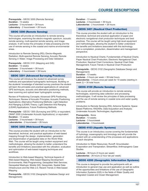
COURSE DESCRIPTIONS<br />
Prerequisite - GEOG 3200 (Remote Sensing)<br />
Duration - 13 weeks<br />
Lectures - 3 hours/week = 39 hours<br />
Laboratory - 2 hours/week = 26 hours<br />
GEOG 3200 (Remote Sensing)<br />
This course will provide an introduction to remote sensing<br />
technologies, examining the electro-magnetic spectrum, acoustic<br />
remote sensing, multi-spectral remote sensing, <strong>and</strong> image<br />
analysis. It will review the principles of data processing <strong>and</strong> the<br />
use of remote sensing in the coastal <strong>and</strong> marine environmental<br />
areas.<br />
Introduction to Remote Sensing (RS); Electro-Magnetic<br />
Radiation; Multi-spectral Remote Sensing; Acoustic Remote<br />
Sensing in Water; Image Processing <strong>and</strong> Data Validation<br />
Prerequisite - GEOG 3101 (Mapping <strong>and</strong> GIS)<br />
Duration - 13 weeks<br />
Lectures - 3 hours/week = 39 hours<br />
Laboratory - 3 hours/week = 39 hours<br />
GEOG 3201 (Advanced Surveying Practices)<br />
This course will introduce the student to advanced survey<br />
methods <strong>and</strong> specialized hydrographic techniques. Building on<br />
the students’ knowledge of st<strong>and</strong>ard survey practices the student<br />
will learn the principles <strong>and</strong> practical applications of; advanced<br />
GPS techniques, acoustic <strong>and</strong> alternative positioning methods,<br />
laser scanning <strong>and</strong> optical laser hydrographic surveys.<br />
Review of Positioning Concepts; Advanced GPS Positioning<br />
Techniques; Review of Acoustic Principles; Acoustic Positioning<br />
Applications; Alternative Positioning Methods; Light Detection<br />
And Ranging (LIDAR) Theory; Light Detection And Ranging<br />
(LIDAR) Applications; Future Positioning Methods<br />
Prerequisite - GEOG 1300 (Surveying <strong>and</strong> GPS); or equivalent;<br />
OMAP 2000 (Underwater Acoustic Applications); or equivalent<br />
Duration - 13 weeks<br />
Lectures - 3 hours/week = 39 hours<br />
Laboratories - 2 hours/week = 26 hours<br />
GEOG 3202 (Web-based Mapping)<br />
This course provides the student with an introduction to the<br />
theoretical, technical, <strong>and</strong> practical application of web-based<br />
mapping through the design, implementation, generation<br />
<strong>and</strong> dissemination of geospatial data on the World Wide<br />
Web. The course will be taught using modern equipment <strong>and</strong><br />
methodologies, allowing the student to better underst<strong>and</strong> the<br />
benefits <strong>and</strong> limitations associated with the utilization, evaluation<br />
<strong>and</strong> optimization of web-based mapping techniques <strong>and</strong><br />
workflows.<br />
Introduction to Web-based Mapping; Technical Aspects of<br />
Web-based Mapping; Web-based Mapping Development<br />
Environments; Web Programming; Geospatial Web Services;<br />
Geospatial Mashups; Mobile GIS; Geoportals; Spatial Data<br />
Infrastructure <strong>and</strong> the Web 2.0; Recent Trends in Web-based<br />
Mapping<br />
Prerequisite - GEOG 3102 (Geographic Database Design <strong>and</strong><br />
Management)<br />
Duration - 13 weeks<br />
Lectures - 3 hours/week = 39 hours<br />
Laboratories - 2 hours/week = 26 hours<br />
GEOG 3401 (Nautical Chart Production)<br />
This course provides the student with an introduction to the<br />
theoretical, technical <strong>and</strong> practical application of paper <strong>and</strong><br />
electronic navigational chart production techniques <strong>and</strong> best<br />
practices. The course will be taught using high-level equipment<br />
<strong>and</strong> methodologies, allowing the student to better underst<strong>and</strong><br />
the benefits <strong>and</strong> limitations associated with this technology<br />
from a compilation, production, dissemination <strong>and</strong> management<br />
perspective.<br />
Introduction to Nautical Charts; Fundamentals of Nautical Charts;<br />
Paper Nautical Chart Production; Electronic Navigational Chart<br />
Production; Nautical Chart Corrections; Nautical Chart Data<br />
Management; Future Trends in Nautical Chart Production<br />
Prerequisite - GEOG 3102 (Geographic Database Design <strong>and</strong><br />
Management)<br />
Duration - 13 weeks<br />
Lectures - 3 hours per week = 39 total hours<br />
Laboratories - 3 hours once per week for 10 weeks (starting in<br />
week 2) = 30 total hours<br />
GEOG 4100 (Remote Sensing)<br />
This course will provide an introduction to remote sensing<br />
technologies, examining data collection <strong>and</strong> processing<br />
methodologies. It will review the principles of data processing<br />
<strong>and</strong> the use of remote sensing in coastal zone <strong>and</strong> water quality<br />
problems.<br />
Introduction to Remote Sensing (RS); Airborne Systems; Space<br />
Based Platforms; RADARs; Data Acquisition <strong>and</strong> Analysis;<br />
Underwater Acoustic Technologies; Applications<br />
Prerequisite - None<br />
Duration - 13 weeks<br />
Lectures - 3 hours/week<br />
Laboratories - 3 hours/week<br />
GEOG 4103 (Aquatic Systems)<br />
This course is an introductory course covering the fundamentals<br />
of hydrology, oceanography <strong>and</strong> limnology <strong>and</strong> will provide the<br />
student with an underst<strong>and</strong>ing of the processes <strong>and</strong> applications<br />
of each discipline.<br />
Introduction to Water Resources; Runoff; Groundwater;<br />
Evaporation <strong>and</strong> Transpiration; Streamflow; Anthropogenic Case<br />
Studies<br />
Lectures - 39 hours (3 hours per week)<br />
Laboratories - 26 hours (2 hour lab per week)<br />
GEOG 4200 (Geographic Information Systems)<br />
This course is designed to provide the participants with an<br />
introduction to general map use <strong>and</strong> application as well as outline<br />
of the opportunities <strong>and</strong> limitations of the use of Geographic<br />
Information Systems (GIS) in the fields of Water Quality <strong>and</strong><br />
Integrated Coastal <strong>and</strong> Ocean Management.<br />
167