Academic Calendar - Fisheries and Marine Institute - Memorial ...
Academic Calendar - Fisheries and Marine Institute - Memorial ...
Academic Calendar - Fisheries and Marine Institute - Memorial ...

Create successful ePaper yourself
Turn your PDF publications into a flip-book with our unique Google optimized e-Paper software.
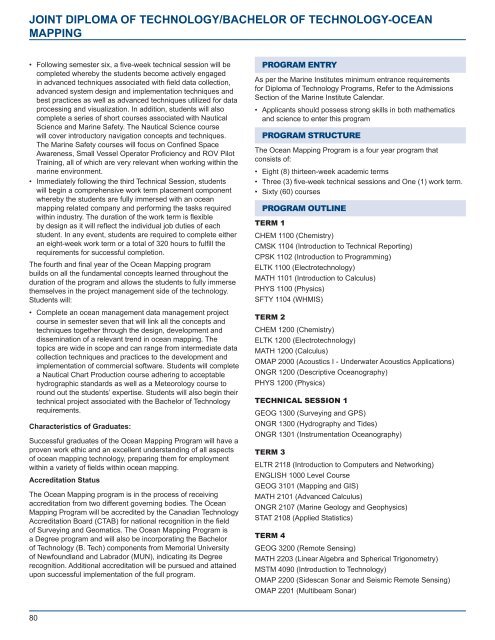
JOINT DIPLOMA OF TECHNOLOGY/BACHELOR OF TECHNOLOGY-OCEAN<br />
MAPPING<br />
• Following semester six, a five-week technical session will be<br />
completed whereby the students become actively engaged<br />
in advanced techniques associated with field data collection,<br />
advanced system design <strong>and</strong> implementation techniques <strong>and</strong><br />
best practices as well as advanced techniques utilized for data<br />
processing <strong>and</strong> visualization. In addition, students will also<br />
complete a series of short courses associated with Nautical<br />
Science <strong>and</strong> <strong>Marine</strong> Safety. The Nautical Science course<br />
will cover introductory navigation concepts <strong>and</strong> techniques.<br />
The <strong>Marine</strong> Safety courses will focus on Confined Space<br />
Awareness, Small Vessel Operator Proficiency <strong>and</strong> ROV Pilot<br />
Training, all of which are very relevant when working within the<br />
marine environment.<br />
• Immediately following the third Technical Session, students<br />
will begin a comprehensive work term placement component<br />
whereby the students are fully immersed with an ocean<br />
mapping related company <strong>and</strong> performing the tasks required<br />
within industry. The duration of the work term is flexible<br />
by design as it will reflect the individual job duties of each<br />
student. In any event, students are required to complete either<br />
an eight-week work term or a total of 320 hours to fulfill the<br />
requirements for successful completion.<br />
The fourth <strong>and</strong> final year of the Ocean Mapping program<br />
builds on all the fundamental concepts learned throughout the<br />
duration of the program <strong>and</strong> allows the students to fully immerse<br />
themselves in the project management side of the technology.<br />
Students will:<br />
• Complete an ocean management data management project<br />
course in semester seven that will link all the concepts <strong>and</strong><br />
techniques together through the design, development <strong>and</strong><br />
dissemination of a relevant trend in ocean mapping. The<br />
topics are wide in scope <strong>and</strong> can range from intermediate data<br />
collection techniques <strong>and</strong> practices to the development <strong>and</strong><br />
implementation of commercial software. Students will complete<br />
a Nautical Chart Production course adhering to acceptable<br />
hydrographic st<strong>and</strong>ards as well as a Meteorology course to<br />
round out the students’ expertise. Students will also begin their<br />
technical project associated with the Bachelor of Technology<br />
requirements.<br />
Characteristics of Graduates:<br />
Successful graduates of the Ocean Mapping Program will have a<br />
proven work ethic <strong>and</strong> an excellent underst<strong>and</strong>ing of all aspects<br />
of ocean mapping technology, preparing them for employment<br />
within a variety of fields within ocean mapping.<br />
Accreditation Status<br />
The Ocean Mapping program is in the process of receiving<br />
accreditation from two different governing bodies. The Ocean<br />
Mapping Program will be accredited by the Canadian Technology<br />
Accreditation Board (CTAB) for national recognition in the field<br />
of Surveying <strong>and</strong> Geomatics. The Ocean Mapping Program is<br />
a Degree program <strong>and</strong> will also be incorporating the Bachelor<br />
of Technology (B. Tech) components from <strong>Memorial</strong> University<br />
of Newfoundl<strong>and</strong> <strong>and</strong> Labrador (MUN), indicating its Degree<br />
recognition. Additional accreditation will be pursued <strong>and</strong> attained<br />
upon successful implementation of the full program.<br />
PROGRAM ENTRY<br />
As per the <strong>Marine</strong> <strong>Institute</strong>s minimum entrance requirements<br />
for Diploma of Technology Programs, Refer to the Admissions<br />
Section of the <strong>Marine</strong> <strong>Institute</strong> <strong>Calendar</strong>.<br />
• Applicants should possess strong skills in both mathematics<br />
<strong>and</strong> science to enter this program<br />
PROGRAM STRUCTURE<br />
The Ocean Mapping Program is a four year program that<br />
consists of:<br />
• Eight (8) thirteen-week academic terms<br />
• Three (3) five-week technical sessions <strong>and</strong> One (1) work term.<br />
• Sixty (60) courses<br />
PROGRAM OUTLINE<br />
TERM 1<br />
CHEM 1100 (Chemistry)<br />
CMSK 1104 (Introduction to Technical Reporting)<br />
CPSK 1102 (Introduction to Programming)<br />
ELTK 1100 (Electrotechnology)<br />
MATH 1101 (Introduction to Calculus)<br />
PHYS 1100 (Physics)<br />
SFTY 1104 (WHMIS)<br />
TERM 2<br />
CHEM 1200 (Chemistry)<br />
ELTK 1200 (Electrotechnology)<br />
MATH 1200 (Calculus)<br />
OMAP 2000 (Acoustics I - Underwater Acoustics Applications)<br />
ONGR 1200 (Descriptive Oceanography)<br />
PHYS 1200 (Physics)<br />
TECHNICAL SESSION 1<br />
GEOG 1300 (Surveying <strong>and</strong> GPS)<br />
ONGR 1300 (Hydrography <strong>and</strong> Tides)<br />
ONGR 1301 (Instrumentation Oceanography)<br />
TERM 3<br />
ELTR 2118 (Introduction to Computers <strong>and</strong> Networking)<br />
ENGLISH 1000 Level Course<br />
GEOG 3101 (Mapping <strong>and</strong> GIS)<br />
MATH 2101 (Advanced Calculus)<br />
ONGR 2107 (<strong>Marine</strong> Geology <strong>and</strong> Geophysics)<br />
STAT 2108 (Applied Statistics)<br />
TERM 4<br />
GEOG 3200 (Remote Sensing)<br />
MATH 2203 (Linear Algebra <strong>and</strong> Spherical Trigonometry)<br />
MSTM 4090 (Introduction to Technology)<br />
OMAP 2200 (Sidescan Sonar <strong>and</strong> Seismic Remote Sensing)<br />
OMAP 2201 (Multibeam Sonar)<br />
80