

COMPENDIO_DE_GEOLOGIA_Bolivia

You also want an ePaper? Increase the reach of your titles
YUMPU automatically turns print PDFs into web optimized ePapers that Google loves.
REVISTA TECNICA <strong>DE</strong> YPFB VOL. 18 (1-2) JUNIO 2000<br />
significativamente el conocimiento sobre la estructura y evolución<br />
de esta parte de la cordillera; probablemente representa la parte<br />
mejor conocida geológicamente en todos Los Andes. En particular,<br />
los dos proyectos científicos “Movilidad de los Márgenes<br />
Continentales Activos” y “Procesos de Deformación en Los<br />
Andes,” con varios subproyectos de diferentes instituciones<br />
alemanas, han realizado grandes esfuerzos para aclarar la estructura<br />
de los Andes utilizando todo tipo de métodos geofísicos y<br />
geológicos. Por lo tanto, es posible y necesario describir con<br />
mayor detalle esta parte de los Andes, a lo largo de 21° S.<br />
Las investigaciones sobre la refracción sísmica sugieren que la<br />
Cordillera Occidental y el Altiplano Occidental representan una<br />
corteza de 70 km de espesor, que sostiene fuertemente a estructuras<br />
verticales (Wigger et al,. 1994).<br />
knowledge of the structure and evolution of this part of the<br />
mountain range significantly, probably it represents the<br />
geologically best known part of the whole Andes. Especially the<br />
two cientific-projects "Mobility of Active Continental Margins"<br />
and "Deformation Proceses in the Andes" with several subprojects<br />
of different german institutions made great efforts to clarify the<br />
structure of the Andes using all kind of geophysical and geological<br />
methods. Therefore it is possible and necessary to describe this part<br />
of the Andes along 21° S in more detail.<br />
Seismic refraction investigations suggest that the Western<br />
Cordillera and the Western Altiplano represent a 70 km thick crust<br />
bearing strongly vertical structures (Wigger et al,. 1994).<br />
72°W<br />
0km<br />
20<br />
40<br />
60<br />
Nazca Plate<br />
Trench 71°<br />
CSS<br />
CSB<br />
Coastal<br />
Cordillera<br />
Coast 70°<br />
Jg<br />
LC<br />
Mv<br />
Longitudinal<br />
Valley<br />
Kg<br />
FM<br />
Ms<br />
Tv<br />
LC<br />
Precordillera<br />
69° Ollagüe 68° 67°<br />
Tg<br />
CB<br />
Pzv Qv Qs<br />
Pzg<br />
LVZ<br />
HCZ<br />
Western<br />
Cordillera<br />
? ?<br />
LC<br />
?<br />
CB<br />
KTs<br />
Altiplano<br />
?<br />
HCZ<br />
LC<br />
66° Tupiza<br />
LC<br />
Eastern<br />
Cordillera<br />
65°<br />
Tarija<br />
Pzs<br />
CB<br />
Subandean<br />
Belt<br />
MC<br />
64° Villamontes<br />
Chaco<br />
63°<br />
0km<br />
20<br />
40<br />
80<br />
earthquake<br />
Lithosphere Mantle<br />
60<br />
100<br />
200<br />
AF<br />
CB<br />
CSB<br />
CSS<br />
FM<br />
HCZ<br />
Jg<br />
Kg<br />
KTs<br />
LC<br />
LVZ<br />
Mc<br />
Ms<br />
Mv<br />
Pzg<br />
Pzs<br />
Pzv<br />
Qs<br />
Qv<br />
Tg<br />
Tv<br />
VF<br />
aseismic front<br />
continental basement<br />
(mainly Precambrian)<br />
continental slope basement<br />
continental slope sediments<br />
forearc mantle lithosphere<br />
(partially hydrated)<br />
high conductivity zone<br />
Jurassic intrusives<br />
Cretaceous intrusives<br />
Cretaceous-Tertiary sediments<br />
lower crust<br />
low (p-wave) velocity zone<br />
middle crust<br />
Mesozoic sediments<br />
Mesozoic arc volcanics<br />
Paleozoic intrusives<br />
Paleozoic sediments<br />
Paleozoic volcanics<br />
Quaternary sediments<br />
Neogene - Quaternary volcanics<br />
Paleogene intrusives<br />
Early Tetiary volcanics<br />
volcanic front<br />
Asthenosphere<br />
80<br />
100<br />
200<br />
300<br />
E. Scheuber 11/95<br />
300<br />
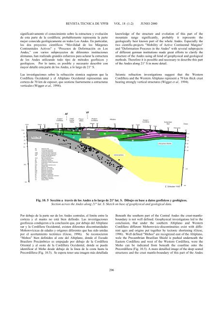
Fig. 10. 5 Sección a través de los Andes a lo largo de 21° lat. S. Dibujo en base a datos geofísicos y geológicos.<br />
Section across the Andes along 21° lat. S. Sketch on base of geophysical and geological data.<br />
Por debajo de la parte sur de los Andes centrales, el límite entre la<br />
corteza y el manto no está bien definido. Las investigaciones<br />
geofísicas condujeron a la conclusión que, por debajo del Altiplano<br />
sur y la Cordillera Occidental, existen diferentes discontiunidades<br />
Mohorovícicas de edades y orígenes diferentes que has sido unidas<br />
por el acortamiento tectónico (Giese, 1996). Se reconocieron<br />
“Mohos” bien definidos al este del Altiplano, donde el Escudo<br />
Brasilero Precámbrico es empujado por debajo de la Cordillera<br />
Oriental y al oeste de la Cordillera Occidental, donde se puede<br />
identificar el Moho desde debajo de la línea de la costa hasta la<br />
Precordillera (Fig. 10.5). Se espera tener una imagen más detallada<br />
Beneath the southern part of the Central Andes the crust-mantleboundary<br />
is not well defined. Geophysical investigatons led to the<br />
conclusion, that under the southern Altiplano and Western<br />
Cordillera different Mohorovicic-discontinuities exist with different<br />
ages and origins put together by tectonic shortening (Giese,<br />
1996). Well defined "Mohos" are recognized east of the Altiplano,<br />
wele the Precambrian Brazilian Shield is pushed underneath the<br />
Eastern Cordillera and west of the Western Cordillera, were the<br />
Moho can be indicated from beneath the coastline onto the<br />
Precordillera (Fig. 10.5). A more detailled image of the deep seated<br />
structures and the crust mantle-boundary of this part of the Andes<br />
206


