

COMPENDIO_DE_GEOLOGIA_Bolivia

Create successful ePaper yourself
Turn your PDF publications into a flip-book with our unique Google optimized e-Paper software.
REVISTA TECNICA <strong>DE</strong> YPFB VOL. 18 (1-2) JUNIO 2000<br />
del lineamiento formado por la zona de fallas de la Cordillera Real,<br />
y su prolongación hacia la ciudad de Sucre, y luego hacia el sur a<br />
través de la falla de Tocloca. En este sector están comprendidas las<br />
cuencas de Puerto Acosta-Escoma, Península de Copacabana,<br />
Sicasica-Belén, Huanuni-Chayanta, y Tica Tica al SW de Potosí.<br />
La secuencia estratigráfica de este sector está representado por las<br />
formaciones Cancañiri, Huanuni, Llallagua, Uncía y Catavi, para el<br />
Silúrico, y Vila Vila, Belén, Sicasica, Collpacucho y Grupo Ambo,<br />
para el Devónico y Carbonífero inferior.<br />
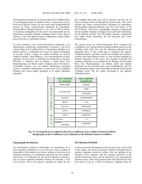
El sector oriental (o Faja Andina-Subandina), comprende a los<br />
afloramientos cordilleranos desarrollados al noroeste y este de la<br />
zona de fallas de la Cordillera Real y el lineamiento señalado en el<br />
párrafo anterior, y comprende las cuencas de Aiquile-Vallegrande<br />
en la parte central, y luego con rumbo meridiano las cuencas<br />
Zudañez-Azurduy, Tarija-Padcaya, y las correspondientes al norte<br />
argentino. En este sector se definieron las formaciones Cancañiri,<br />
Kirusillas y Tarabuco, para el Silúrico, y Santa Rosa, Icla,<br />
Huamampampa, Los Monos, Iquiri y Saipurú, para el Devónico y<br />
Carbonífero inferior. Las tres últimas formaciones presentan<br />
escasos y reducidos afloramientos en este sector de la Cordillera<br />
Oriental, pero tienen amplio desarrollo en la región subandina<br />
adyacente.<br />
FAJA PLEGADA<br />
<strong>DE</strong> HUARINA<br />
the Cordillera Real fault zone and its extension into the city of<br />
Sucre, and later to the south through the Tocloca fault. This sector<br />
includes the Puerto Acosta-Escoma, Península de Copacabana,<br />
Sicasica-Belén, Huanuni-Chayanta, and Tica Tica basins, to the<br />
SW of Potosí. This sector’s stratigraphic sequence is represented<br />
by the Cancañiri, Huanuni, Llallagua, Uncía and Catavi formations,<br />
for the Silurian, and the Vila Vila, Belén, Sicasica, Collpacucho<br />
and Ambo Group formations, for the Devonian and Lower<br />
Carboniferous.<br />
The eastern sector (or Andean-Subandean Belt) comprises the<br />
Cordilleran Cicle outcrops that developed northeast and east of the<br />
Cordillera Real fault zone and the lineament indicated in the<br />
paragraph above. In the central part, it comprises the Aiquile-<br />
Vallegrande basins, and then, towards the meridian, the Zudañez-<br />
Azurduy and Tarija-Padcaya basins, as well as those belonging to<br />
northern Argentina. In this sector, the Cancañiri, Kirusillas and<br />
Tarabuco formations were defined for the Silurian, and the Santa<br />
Rosa, Icla, Huamampampa, Los Monos, Iquiri and Saipurú<br />
formations for the Devonian and Lower Carboniferous. The last<br />
three formations display scarce and reduced outcrops in the Eastern<br />
Cordillera sector, but are widely developed in the adjacent<br />
Subandean region.<br />
FAJA ANDINA-<br />
SUBANDINA<br />
C I C L O C O R D I L L E R A N O<br />
GRUPO AMBO<br />
SAIPURU<br />
IQUIRI<br />
COLLPACUCHO<br />
LOS MONOS<br />
SICASICA<br />
HUAMAMPAMPA<br />
BELEN<br />
ICLA<br />
VILA VILA<br />
SANTA ROSA<br />
CATAVI<br />
TARABUCO<br />
UNCIA<br />
KIRUSILLAS<br />
LLALLAGUA ? ? ?<br />
HUANUNI<br />
CANCAÑIRI<br />
CANCAÑIRI<br />
Fig. 3.3 Estratigrafía de los sedimentos del Ciclo Cordillerano en la Cordillera Oriental de <strong>Bolivia</strong>.<br />
Stratigraphy of the Cordilleran Cycle sediments in the <strong>Bolivia</strong>n Eastern Cordillera.<br />
Faja plegada de Huarina<br />
Los movimientos oclóyicos, relacionados con plutonismo en el<br />
norte argentino, produjeron en el sur del país, como se indicó al<br />
desarrollar el ciclo anterior, dos efectos: primero la elevación de la<br />
secuencia tacsariana, y la consiguiente exposición de rocas cambroordovícicas,<br />
y la formación de una cuenca distensiva asimétrica,<br />
con un sector occidental profundo (cuencas de Chayanta y Tica<br />
Tica de hasta 1500 m de espesor), separado por medio de una<br />
The Huarina Fold Belt<br />
As discussed in the development of the previous cycle, in the south<br />
of the country, the ocloyic movements related to the plutonism in<br />
northern Argentina caused two effects: first, the uplifting of the<br />
Tacsarian Cycle sequence, and the ensuing exposition of the<br />
Cambro-Ordovician rocks, and the formation of an assymmetrical<br />
distensive basin, with a deep western sector (the Chayanta and Tica<br />
Tica basins of up to a 1,500 m thickness), separated from the<br />
48


