- Page 3 and 4:
Copyright Notice This work is copyr
- Page 5 and 6:
This page is intentionally blank Au
- Page 7 and 8:
6 Service Reference Model .........
- Page 9 and 10:
Figure 4-26: Tasks measurement bran
- Page 11 and 12:
This page is intentionally blank Au
- Page 13 and 14:
1.1 Audience This document is targe
- Page 15 and 16:
systems and process frameworks, suc
- Page 17 and 18:
At an agency level, these business
- Page 19 and 20:
� bridging data architectures. Th
- Page 21 and 22:
This page is intentionally blank Au
- Page 23 and 24:
LAYER DESCRIPTION Service Describes
- Page 25 and 26:
3.4 Metamodel elements by layer 3.4
- Page 27 and 28:
Attributes Type Description Code St
- Page 29 and 30:
3.4.3 Service layer The Service lay
- Page 31 and 32:
Entity Name Service Entity Descript
- Page 33 and 34:
Entity Name TRM Service Area Entity
- Page 35 and 36:
This page is intentionally blank Au
- Page 37 and 38:
Figure 4-1: The PRM Classification
- Page 39 and 40:
Figure 4-2: Linking the PRM to the
- Page 41 and 42:
Figure 4-5: Combining the TRM and t
- Page 43 and 44:
4.1.4.2 The Outcome Process Model F
- Page 45 and 46:
The PRM is structured in a way that
- Page 47 and 48:
4.1.4.5 Other References Australian
- Page 49 and 50:
The PRM is able to: � support pla
- Page 51 and 52:
4.1.5.3 Indirect Benefits The indir
- Page 53 and 54:
Level 4 Measurement groupings Level
- Page 55 and 56:
4.3.1 Program outcomes The followin
- Page 57 and 58:
Subtype Measures of effects that in
- Page 59 and 60:
Measurement Area Measures of effect
- Page 61 and 62:
4.4.1 Product consumption 2101 Time
- Page 63 and 64:
4.4.2 Service delivery 2201 Availab
- Page 65 and 66:
Measurement Area Rationale Defined
- Page 67 and 68:
3 OUTPUTS 31 Products 32 Services 3
- Page 69 and 70:
Measurement Area Rationale Defined
- Page 71 and 72:
4.6 Work domain ‘Work’ is the g
- Page 73 and 74:
Measurement Area Rationale Defined
- Page 75 and 76:
4.6.2 Ad hoc tasks 4201 Task effici
- Page 77 and 78:
Understanding the performance relat
- Page 79 and 80:
[4305] Process Reliability [4306] P
- Page 81 and 82:
4.7 Inputs domain It could be argue
- Page 83 and 84:
Measurement Area Rationale Defined
- Page 85 and 86:
4.7.2 Data and information In the i
- Page 87 and 88:
Measurement Area Rationale Defined
- Page 89 and 90:
Measurement Area Rationale Defined
- Page 91 and 92:
Measurement Area Rationale Defined
- Page 93 and 94:
Measurement Area Rationale Defined
- Page 95 and 96:
4.7.5 Money 55 Money 5501 Costs (mo
- Page 97 and 98:
First order Second order Higher ord
- Page 99 and 100:
Measurement Indicator Rationale Cur
- Page 101 and 102:
4.9.2 Example 2: OPM used in operat
- Page 103 and 104:
This page is intentionally blank Au
- Page 105 and 106:
BRM Business Area 1 Contains lines
- Page 107 and 108:
[109] Employment [10901] Human Reso
- Page 109 and 110:
5.3 Services for Citizens Business
- Page 111 and 112:
Business Sub Function Defines the s
- Page 113 and 114:
Business Sub Function Defines the s
- Page 115 and 116:
Business Sub Function Defines the s
- Page 117 and 118:
Business Sub Function Defines the s
- Page 119 and 120:
Business Sub Function Defines the s
- Page 121 and 122:
5.3.9 [109] Employment A Employment
- Page 123 and 124:
Business Sub Function Defines the s
- Page 125 and 126:
5.3.12 [1012] Immigration A Immigra
- Page 127 and 128:
5.3.14 [1014] International Relatio
- Page 129 and 130: Business Sub Function Defines the s
- Page 131 and 132: Business Sub Function Defines the s
- Page 133 and 134: 5.3.17 [1017] Natural Resources A N
- Page 135 and 136: Business Sub Function Defines the s
- Page 137 and 138: Business Sub Function Defines the s
- Page 139 and 140: Business Sub Function Defines the s
- Page 141 and 142: 5.3.24 [1024] Trade A Trade involve
- Page 143 and 144: Business Sub Function Defines the s
- Page 145 and 146: 5.4.1 [201] Credit and Insurance F
- Page 147 and 148: Business Sub Function Defines the s
- Page 149 and 150: 5.5 Services Support Business Area
- Page 151 and 152: Business Sub Function Defines the s
- Page 153 and 154: Business Sub Function Defines the s
- Page 155 and 156: 5.6.1 [401] Administrative Manageme
- Page 157 and 158: Business Sub Function Defines the s
- Page 159 and 160: Business Sub Function Defines the s
- Page 161 and 162: Business Sub Function Defines the s
- Page 163 and 164: Example 1: Financial Assistance to
- Page 165 and 166: 6 Service Reference Model 6.1 Intro
- Page 167 and 168: 6.3 Customer Services Domain The Cu
- Page 169 and 170: 6.3.2 [1002] Customer Preferences C
- Page 171 and 172: 6.4.2 [1102] Routing and Scheduling
- Page 173 and 174: 6.5.1 [1201] Management of Process
- Page 175 and 176: 6.5.4 [1204] Supply Chain Managemen
- Page 177 and 178: 6.6.2 [1302] Document Management Ca
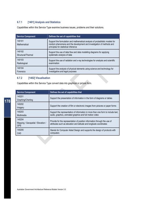
- Page 179: 6.7 Business Analytical Services Do
- Page 183 and 184: 6.8.1 [1501] Data Management Capabi
- Page 185 and 186: 6.8.4 [1504] Assets/Materials Manag
- Page 187 and 188: 6.9 Support Services Domain The Sup
- Page 189 and 190: 6.9.2 [1602] Collaboration Capabili
- Page 191 and 192: 6.9.6 [1606] Forms Management Capab
- Page 193 and 194: 7 Data Reference Model 7.1 Introduc
- Page 195 and 196: 7.4 DRM Implementation Framework Th
- Page 197 and 198: Standardisation Area Description Da
- Page 199 and 200: The DRM abstract model is an archit
- Page 201 and 202: 7.7 Data Context Standardisation Ar
- Page 203 and 204: 7.7.2 Guidance 7.7.2.1 The COI, its
- Page 205 and 206: � Though cardinality is not expre
- Page 207 and 208: Term Definition Other AGA Reference
- Page 209 and 210: Figure 7-8: US DOI DRM Classificati
- Page 211 and 212: section, as well as through the cat
- Page 213 and 214: The following are definitions for e
- Page 215 and 216: Term Definition Document (human rea
- Page 217 and 218: Concept Attribute Description Examp
- Page 219 and 220: Concept Attribute Description Examp
- Page 221 and 222: Figure 7-13: US FEA BRM Logical Dat
- Page 223 and 224: While it may have been physical evi
- Page 225 and 226: Based upon this analysis, the archi
- Page 227 and 228: architect should plan to provide th
- Page 229 and 230: Term Definition Exchange Package An
- Page 231 and 232:
7.9 DRM Abstract Model This section
- Page 233 and 234:
The table below summarises each of
- Page 235 and 236:
Term Definition Digital Data Resour
- Page 237 and 238:
Concept Attribute Description Examp
- Page 239 and 240:
Concept Attribute Description Examp
- Page 241 and 242:
The following are definitions for e
- Page 243 and 244:
The table below provides attributes
- Page 245 and 246:
Supplier A Supplier is an entity (p
- Page 247 and 248:
This page is intentionally blank Au
- Page 249 and 250:
8.2 Structure Organised in a hierar
- Page 251 and 252:
8.3.1 [3001] Access Channels Access
- Page 253 and 254:
8.3.2 [3002] Delivery Channels Deli
- Page 255 and 256:
Service Standards Defined by Exampl
- Page 257 and 258:
Service Standards Defined by Exampl
- Page 259 and 260:
8.4 Service Platform and Infrastruc
- Page 261 and 262:
8.4.2 [3102] Delivery Servers Deliv
- Page 263 and 264:
Service Standards Defines Examples
- Page 265 and 266:
8.4.5 [3105] Hardware/Infrastructur
- Page 267 and 268:
Service Standards Defines Examples
- Page 269 and 270:
8.5 Component Framework Service Are
- Page 271 and 272:
Service Standards Defines Examples
- Page 273 and 274:
8.5.3 [3203] Business Logic Busines
- Page 275 and 276:
8.5.5 [3205] Data Management Data m
- Page 277 and 278:
8.6 Service Interface and Integrati
- Page 279 and 280:
Service Standards Defines Examples
- Page 281 and 282:
8.6.3 [3303] Interface Interface de
- Page 283 and 284:
Term Definition Australian Governme
- Page 285 and 286:
Term Definition Business Service [t
- Page 287 and 288:
Term Definition Context [top] As re
- Page 289 and 290:
Term Definition Data Element Regist
- Page 291 and 292:
Term Definition Digital Rights Mana
- Page 293 and 294:
Term Definition Exchange Package [t
- Page 295 and 296:
Term Definition Management Context
- Page 297 and 298:
Term Definition Preferred Term [top
- Page 299 and 300:
Term Definition Semantic Web [top]
- Page 301 and 302:
Term Definition Technical Reference
- Page 303 and 304:
Term Definition eXtensible Markup L