

watervulnerability
watervulnerability
watervulnerability

You also want an ePaper? Increase the reach of your titles
YUMPU automatically turns print PDFs into web optimized ePapers that Google loves.
Sawtooth National Forest Watershed Vulnerability Assessment, Intermountain Region (R4)<br />
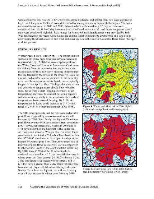
were considered low risk, 20 to 40% were considered moderate, and greater than 40% were considered<br />
high risk. Changes in Winter 95 were determined by seeing how many days with the highest 5% flows<br />
increased from current to 2040 and 2080. Subwatersheds with less than a 0.5 day increase were<br />
considered low risk, 0.5 to 2 day increases were considered moderate risk, and increases greater than 2<br />
days were considered high risk. Risk ratings for Winter 95 and MeanSummer were provided by Seth<br />
Wenger, based on his recent work evaluating climate variables relative to geomorphic and land use in<br />
determining the distributions of bull trout and other species in the Interior Columbia River Basin (Wenger<br />
et al. (in press)).<br />
EXPOSURE RESULTS<br />
Winter Peak Flows (Winter 95) – The Upper Salmon<br />
subbasin has many high-elevation subwatersheds and<br />
is surrounded by 12,000-foot snow-capped peaks of<br />
the White Cloud and Sawtooth Mountains. Cold, dense<br />
air sinking from the mountains into the valley is the<br />
main reason for the chilly early-morning temperatures<br />
that are frequently the lowest in the lower 48 states. As<br />
a result, mid-winter rain-on-snow events are currently<br />
very rare. Rain-on-snow events that do occur typically<br />
happen in late April to May. The high elevation terrain<br />
and cold winter temperatures should help to buffer<br />
snow packs from winter flooding. However, as air<br />
temperatures increase, this natural buffering capacity<br />
will diminish, especially in those subwatersheds where<br />
temperatures hover around freezing. By 2100, air<br />
temperatures in Idaho could increase by 5°F (with a<br />
range of 2-9°F) in winter and summer (EPA 1998).<br />
The VIC model projects that the risk from mid-winter<br />
peak flows triggered by rain-on-snows events will<br />
increase by 2080. Specifically, the highest 5% winterpeak<br />
flows average 0.88 days under current conditions<br />
(1977-1997), but increase to 2.6 days in 2040 and to<br />
4.44 days in 2080 on the Sawtooth NRA under the<br />
A1B emission scenario. Wenger et al. (in press) found<br />
some areas in the interior Columbia River basin within<br />
the 1977-1997 timeframe to have up to 8.4 days at the<br />
highest 5% winter peak flow. Thus, the current risk of<br />
mid-winter peak flows is relatively low in comparison<br />
to other areas. However, these risks will be increasing.<br />
By 2040, three (5.9%) of the 51 subwatersheds<br />
analyzed have less than a 0.5 day (low risk) increase in<br />
winter peak low from current; 34 (66.7%) have a 0.5 to<br />
2 day (moderate risk) increase from current; and 14<br />
(27.4%) have a greater-than-2-day (high risk) increase<br />
from current (Figure 8). Meadow, Stanley Lake, and<br />
Smiley Creek have the highest risk with each having<br />
over a 4 day increase in winter peak flows by 2040.<br />
168 Assessing the Vulnerability of Watersheds to Climate Change<br />
Figure 8. Winter peak flow risk in 2040; highest<br />
(red); moderate (yellow); and lowest (green)<br />
Figure 9. Winter peak flow risk in 2080; highest<br />
(red); moderate (yellow); and lowest (green)