

watervulnerability
watervulnerability
watervulnerability

Create successful ePaper yourself
Turn your PDF publications into a flip-book with our unique Google optimized e-Paper software.
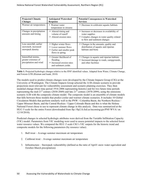
Helena National Forest Watershed Vulnerability Assessment, Northern Region (R1)<br />
Projected Climatic<br />
Changes<br />
Anticipated Watershed<br />
Response<br />
Warmer air temperatures • Warmer water<br />
temperature in streams<br />
Changes in precipitation<br />
amounts and timing<br />
Less snowfall, earlier<br />
snowmelt, increased<br />
snowpack density<br />
Intensified storms,<br />
greater extremes of<br />
precipitation and wind<br />
• Altered timing and<br />
volume of runoff<br />
• Altered erosion rates<br />
• Higher winter flows<br />
• Lower summer flows<br />
• Earlier and smaller peak<br />
flows in spring<br />
• Greater likelihood of<br />
flooding<br />
• Increased erosion rates<br />
and sediment yields<br />
50 Assessing the Vulnerability of Watersheds to Climate Change<br />
Potential Consequences to Watershed<br />
Services<br />
• Decrease in coldwater aquatic habitats<br />
• Increases or decreases in availability of<br />
water supplies<br />
• Complex changes in water quality related<br />
to flow and sediment changes<br />
• Changes in the amounts, quality and<br />
distribution of aquatic and riparian<br />
habitats and biota<br />
• Changes in aquatic and riparian habitats<br />
• Increased damage to roads, campgrounds,<br />
and other facilities<br />
Table 1. Projected hydrologic changes relative to the HNF identified values. Adapted from Water, Climate Change,<br />
and Forests GTR (Rieman and Isaak, 2010)<br />
The models used to predict climate changes were developed by the Climate Impacts Group (CIG) at the<br />
University of Washington. The Climate Impacts Group selected the A1B climate scenario to provide<br />
projections most relevant for vulnerability assessment and scenario planning exercises. They then<br />
modeled change (from time period 1916-2006 representing historic) and for two future time periods<br />
representing the mid-21 st century (2030-2049) and late 21 st century (2070-2099), using the emissions<br />
scenario A1B with the composite climate model. The composite model is an ensemble of climate models<br />
that falls between those models that predict cooler and warmer climate scenarios. It includes 10 Global<br />
Circulation Models that perform similarly well in the PNW / Columbia Basin, the Northern Rockies /<br />
Upper Missouri Basin, and the Central Rockies / Upper Colorado Basin and this is what the Helena<br />
National Forest chose to use to represent climate change in this analysis. Data was summarized at the<br />
HUC-5 scale for the entire Forest (downloaded from ftp://ftp2.fs.fed.us/incoming/gis/PNF/WVA/ on<br />
12/10/2010).<br />
Predicted changes in selected hydrologic attributes were derived from the Variable Infiltration Capacity<br />
(VIC) model. Parameters from VIC modeling were used to assess potential impacts to the selected forest<br />
water resource values. We compared the HUC-5 scale CIG’s VIC outputs for the historic trend and<br />
composite models for the following parameters (by resource value):<br />
1. Bull trout – Average summer maximum air temperature<br />
2. Cutthroat trout – Average summer maximum air temperature<br />
3. Infrastructure – Snowpack vulnerability (defined as the ratio of April1 snow water equivalent and<br />
October-March precipitation)