

watervulnerability
watervulnerability
watervulnerability

Create successful ePaper yourself
Turn your PDF publications into a flip-book with our unique Google optimized e-Paper software.
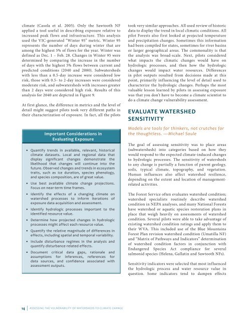
climate (Casola et al. 2005). Only the Sawtooth NF<br />
applied a tool useful in describing exposure relative to<br />
increased peak flows and infrastructure. This analysis<br />
used the VIC-generated “Winter 95” metric. Winter 95<br />
represents the number of days during winter that are<br />
among the highest 5% of flows for the year. Winter was<br />
defined as Dec. 1 – Feb. 28. Changes in Winter 95 were<br />
determined by comparing the increase in the number<br />
of days with the highest 5% flows between current and<br />
predicted conditions (2040 and 2080). Subwatersheds<br />
with less than a 0.5-day increase were considered low<br />
risk, those with 0.5- to 2-day increases were considered<br />
moderate risk, and subwatersheds with increases greater<br />
than 2 days were considered high risk. Results of this<br />
analysis for 2040 are depicted in Figure 9.<br />
At first glance, the difference in metrics and the level of<br />
detail might suggest pilots took very different paths in<br />
their characterization of exposure. In fact, all the pilots<br />
Important Considerations in<br />
Evaluating Exposure<br />
• Quantify trends in available, relevant, historical<br />
climate datasets. Local and regional data that<br />
display significant changes demonstrate the<br />
likelihood that changes will continue into the<br />
future. Observed changes and trends in ecosystem<br />
traits, such as ice duration, species phenology,<br />
and species composition, are of great value.<br />
• Use best available climate change projections.<br />
Focus on near-term time frames.<br />
• Identify the effects of a changing climate on<br />
watershed processes to inform iterations of<br />
exposure data acquisition and assessment.<br />
• Identify hydrologic processes important to the<br />
identified resource value.<br />
• Determine how projected changes in hydrologic<br />
processes might affect each resource value.<br />
• Quantify the relative magnitude of differences in<br />
effects, including spatial and temporal variability.<br />
• Include disturbance regimes in the analysis and<br />
quantify disturbance-related effects.<br />
• Document critical data gaps, rationale and<br />
assumptions for inferences, references for<br />
data sources, and confidence associated with<br />
assessment outputs.<br />
14 | ASSESSING THE VULNERABILITY OF WATERSHEDS TO CLIMATE CHANGE<br />
took very similar approaches. All used review of historic<br />
data to display the trend in local climatic conditions. All<br />
pilot Forests also first looked at projected temperature<br />
and precipitation changes. Sometimes this information<br />
had been compiled for states, sometimes for river basins<br />
or larger geographical areas. The commonality is that<br />
the analysis was broad-scale. Next, pilots considered<br />
what impacts the climatic changes would have on<br />
hydrologic processes, and then how the hydrologic<br />
changes would impact water resources. Differences<br />
in pilot outputs resulted from decisions made at this<br />
point, primarily influencing the level of detail used to<br />
characterize the hydrologic changes. Perhaps the most<br />
valuable lesson learned by pilots in assessing exposure<br />
was that you don’t have to become a climate scientist to<br />
do a climate change vulnerability assessment.<br />
EVALUATE WATERSHED<br />
SENSITIVITY<br />
Models are tools for thinkers, not crutches for<br />
the thoughtless. —Michael Soule<br />
The goal of assessing sensitivity was to place areas<br />
(subwatersheds) into categories based on how they<br />
would respond to the expected climate-induced changes<br />
to hydrologic processes. The sensitivity of watersheds<br />
to any change is partially a function of parent geology,<br />
soils, typical climate, topography, and vegetation.<br />
Human influences also affect watershed resilience,<br />
depending on the extent and location of managementrelated<br />
activities.<br />
The Forest Service often evaluates watershed condition;<br />
watershed specialists routinely describe watershed<br />
condition in NEPA analyses, and many National Forests<br />
have watershed or aquatic species restoration plans in<br />
place that weigh heavily on assessments of watershed<br />
condition. Several pilots were able to take advantage of<br />
existing watershed condition ratings and apply them to<br />
their WVA. This included use of the Blue Mountains<br />
Forest Plan revision watershed condition (Umatilla NF)<br />
and “Matrix of Pathways and Indicators” determination<br />
of watershed condition factors in conjunction with<br />
Endangered Species Act compliance for several<br />
salmonid species (Helena, Gallatin and Sawtooth NFs).<br />
Sensitivity indicators were selected that most influenced<br />
the hydrologic process and water resource value in<br />
question. Some indicators tend to dampen effects