

watervulnerability
watervulnerability
watervulnerability

You also want an ePaper? Increase the reach of your titles
YUMPU automatically turns print PDFs into web optimized ePapers that Google loves.
Sawtooth National Forest Watershed Vulnerability Assessment, Intermountain Region (R4)<br />
By 2080, only one (2.0%) subwatershed remains in a low risk category and three (5.9%) subwatersheds<br />
remain in a moderate risk category (Figure 9). The remaining 47 (92.1%) subwatersheds are in a high risk<br />
category, with Elk, Meadow, Pettit Lake, Smiley, Stanley Lake, and Upper Redfish Lake Creeks showing<br />
over a 5-day increase in winter peak flows.<br />
Summer Baseflows (Mean Summer)<br />
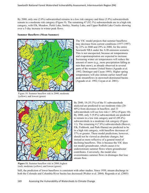
Figure 10. Summer baseflow risk in 2040; moderate<br />
(yellow); and lowest (green)<br />
169 Assessing the Vulnerability of Watersheds to Climate Change<br />
The VIC model projects that summer baseflows<br />
may decrease from current conditions (1977-1997)<br />
by 22% in 2040 and 29% in 2080, for the entire<br />
Sawtooth NRA under the A1B emission scenario.<br />
This is not unexpected, because air temperatures<br />
and evapotranspiration are expected to increase.<br />
Increasing winter air temperatures will reduce the<br />
amount of snow (e.g., more precipitation falling as<br />
rain than snow), as already observed in several<br />
parts of the western United States (Aguado et al.<br />
1992; Dettinger and Cayan 1995). Higher spring<br />
temperatures will also initiate earlier runoff and<br />
peak streamflows in snowmelt-dominated basins<br />
(Aguado et al. 1992; Cayan et al. 2001).<br />
By 2040, 18 (35.3%) of the 51 subwatersheds<br />
analyzed are predicted to see moderate risks (20-<br />
40%) from decreases in baseflow, and 33<br />
subwatersheds will see low risk (< 20%) (Figure 10).<br />
By 2080, only 5 (9.8%) subwatersheds are predicted<br />
to remain in a low risk category and 42 (89.4%)<br />
subwatersheds in a moderate risk category (Figure<br />
11). The remaining 4 (7.8%) subwatersheds (Beaver,<br />
Elk, Fishhook, and Park-Hanna) are predicted to be<br />
in a high risk category, with baseflow decreases of<br />
37% or greater. These model predictions, however,<br />
should not be viewed as absolute changes, but<br />
instead as more reflective of a general trend of<br />
declining baseflows. This is because the VIC does<br />
not model groundwater, which causes it to<br />
underestimate summer flows where groundwater<br />
contributes. Conversely, the model also<br />
overestimates summer flows in drainages that lose<br />
stream flow.<br />
Figure 11. Summer baseflow risk in 2080; highest<br />
(red); moderate (yellow); and lowest (green)<br />
Still, the prediction of lower baseflows is consistent with other studies. Since 1950, stream discharge in<br />
both the Colorado and Columbia River basins has decreased (Walter et al. 2004). Regonda et al. (2005)