

watervulnerability
watervulnerability
watervulnerability

You also want an ePaper? Increase the reach of your titles
YUMPU automatically turns print PDFs into web optimized ePapers that Google loves.
sensitivity. Most were derived from the Watershed<br />
Condition Classification (Figure 12). The Gallatin NF<br />
characterization of sensitivity had two components:<br />
one included intrinsic watershed attributes, the other<br />
included levels of disturbance. The Watershed Condition<br />
Classification ratings of “functioning,” “functioning at<br />
risk,” and “non-functioning” were used to characterize<br />
disturbance. Since National Forests and Grasslands now<br />
have completed the Watershed Condition Classification,<br />
this data would be useful in conducting future WVAs.<br />
Pilot Forests that took advantage of existing condition<br />
ratings tended to apply them to all resource issues. Several<br />
pilot Forests, however, identified different indicators for<br />
each resource value. While many indicators are important<br />
influences on multiple water resources, some are not.<br />
For instance, the most important factors affecting peak<br />
flows and infrastructure may differ from those that most<br />
influence springs and other aquatic habitats.<br />
Pilot Forests took several approaches to developing<br />
ratings of watershed sensitivity. In the simplest<br />
applications (Ouachita and Chequamegon-Nicolet<br />
NFs), sensitivity indicators (e.g., basin slope, peat land<br />
type) were used to place watersheds into different<br />
categories. Other pilot Forests produced sensitivity<br />
ratings based on numerous indicators. When multiple<br />
indicators were used, pilot Forests developed methods<br />
of weighting and rating the relative influence of the<br />
attributes. For example, when considering influences<br />
on stream habitat, the amount of water withdrawn<br />
from a subwatershed is likely more important than the<br />
condition of terrestrial vegetation, and would therefore<br />
be given greater weight in calculating a sensitivity score.<br />
One approach to weighting sensitivity indicators, from<br />
Subwatershed Attribute Type of Attribute Relative Weight<br />
Geochemistry of parent geology Inherent to watershed 0.25 Buffer<br />
Extent of glaciation Inherent to watershed 0.75 Buffer<br />
Aspect Inherent to watershed 0.50 Additive<br />
Hydroclimatic regime Inherent to watershed 1.0 Additive<br />
Weighted precipitation Inherent to watershed 1.0 Buffer<br />
Extent of surface water features Inherent to watershed 1.0 Buffer<br />
Extent of large-scale pine beetle<br />
mortality<br />
16 | ASSESSING THE VULNERABILITY OF WATERSHEDS TO CLIMATE CHANGE<br />
Sensitivity x Stressors<br />
Risk Ranking Matrix<br />
Stressors<br />
Net Effect Relative to<br />
Climate Change<br />
Inherent to watershed 0.5 Buffer (short term)<br />
Water uses Anthropogenic 1.0 Additive<br />
Development (primarily roads) Anthropogenic 0.5 Additive<br />
Extent of beetle salvage Anthropogenic 0.5 Additive (short term)<br />
Table 6. Summary of attribute types affecting subwatershed resilience to climate change (White River NF)<br />
Sensitivity<br />
Low<br />
Moderate<br />
High<br />
Low Moderate<br />
Low<br />
Low<br />
High<br />
High<br />
Low Low<br />
Low<br />
High<br />
High<br />
High<br />
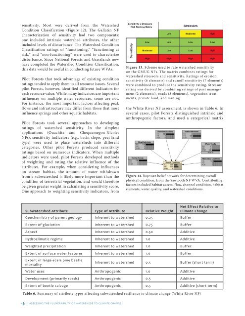
Figure 13. Scheme used to rate watershed sensitivity<br />
on the GMUG NFs. The matrix combines ratings for<br />
water shed stressors and sensitivity. Ratings of erosion<br />
sensitivity (6 elements) and runoff sensitivity (7 elements)<br />
were combined to produce the sensitivity rating. Stressor<br />
rating was derived by combining ratings of past management<br />
(2 elements), roads (3 elements), vegetation treatments,<br />
private land, and mining.<br />
the White River NF assessment, is shown in Table 6. In<br />
several cases, pilot Forests distinguished intrinsic and<br />
anthropogenic factors, and used a categorical matrix<br />
Figure 14. Bayesian belief network for determining overall<br />
physical condition, from the Sawtooth NF WVA. Contri buting<br />
factors included habitat access, flow, channel condition, habitat<br />
elements, water quality, and watershed conditions.