

watervulnerability
watervulnerability
watervulnerability

Create successful ePaper yourself
Turn your PDF publications into a flip-book with our unique Google optimized e-Paper software.
highest priority for management actions. If, for instance,<br />
a highly-valued water resource has a very limited<br />
distribution, management options are limited. If the<br />
value is more widely dispersed, managers must decide<br />
if the most vulnerable areas should be highest priority,<br />
or if they should focus their efforts on sustaining the<br />
values in areas with lower vulnerability. Scale must be<br />
considered in this discussion. Naturally, for resources<br />
(especially species) whose range is greater than the<br />
analysis area, discussion of results with other land<br />
managers will be necessary.<br />
The greatest value of WVA results is in identifying<br />
geographical areas that are priorities for actions<br />
designed to maintain or improve watershed resilience.<br />
Several pilot Forests are already using the results to<br />
this end. The recently completed Watershed Condition<br />
Classification (Figure 21) led to the designation of<br />
priority subwatersheds for improvement actions. The<br />
connection of the WVA to setting these priorities is<br />
clear. One pilot Forest (Coconino NF) applied WVA<br />
findings during this priority-setting process. On many<br />
National Forests and Grasslands, strategic plans have<br />
been developed to guide restoration and management<br />
efforts. In these cases, the vulnerability assessment<br />
process will be used to reassess existing priorities and<br />
to determine if changes are warranted. None of the pilot<br />
Forests were engaged in Land Management Planning<br />
during the WVA, but results have clear application<br />
to that effort in helping to identify priority areas for<br />
management.<br />
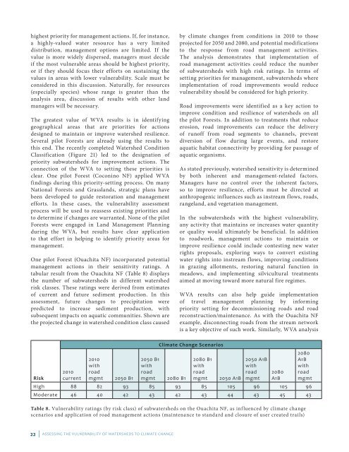
One pilot Forest (Ouachita NF) incorporated potential<br />
management actions in their sensitivity ratings. A<br />
tabular result from the Ouachita NF (Table 8) displays<br />
the number of subwatersheds in different watershed<br />
risk classes. These ratings were derived from estimates<br />
of current and future sediment production. In this<br />
assessment, future changes to precipitation were<br />
predicted to increase sediment production, with<br />
subsequent impacts on aquatic communities. Shown are<br />
the projected change in watershed condition class caused<br />
Risk<br />
2010<br />
current<br />
2010<br />
with<br />
road<br />
mgmt 2050 B1<br />
22 | ASSESSING THE VULNERABILITY OF WATERSHEDS TO CLIMATE CHANGE<br />
by climate changes from conditions in 2010 to those<br />
projected for 2050 and 2080, and potential modifications<br />
to the response from road management activities.<br />
The analysis demonstrates that implementation of<br />
road management activities could reduce the number<br />
of subwatersheds with high risk ratings. In terms of<br />
setting priorities for management, subwatersheds where<br />
implementation of road improvements would reduce<br />
vulnerability should be considered for high priority.<br />
Road improvements were identified as a key action to<br />
improve condition and resilience of watersheds on all<br />
the pilot Forests. In addition to treatments that reduce<br />
erosion, road improvements can reduce the delivery<br />
of runoff from road segments to channels, prevent<br />
diversion of flow during large events, and restore<br />
aquatic habitat connectivity by providing for passage of<br />
aquatic organisms.<br />
As stated previously, watershed sensitivity is determined<br />
by both inherent and management-related factors.<br />
Managers have no control over the inherent factors,<br />
so to improve resilience, efforts must be directed at<br />
anthropogenic influences such as instream flows, roads,<br />
rangeland, and vegetation management.<br />
In the subwatersheds with the highest vulnerability,<br />
any activity that maintains or increases water quantity<br />
or quality would ultimately be beneficial. In addition<br />
to roadwork, management actions to maintain or<br />
improve resilience could include contesting new water<br />
rights proposals, exploring ways to convert existing<br />
water rights into instream flows, improving conditions<br />
in grazing allotments, restoring natural function in<br />
meadows, and implementing silvicultural treatments<br />
aimed at moving toward more natural fire regimes.<br />
WVA results can also help guide implementation<br />
of travel management planning by informing<br />
priority setting for decommissioning roads and road<br />
reconstruction/maintenance. As with the Ouachita NF<br />
example, disconnecting roads from the stream network<br />
is a key objective of such work. Similarly, WVA analysis<br />
Climate Change Scenarios<br />
2050 B1<br />
with<br />
road<br />
mgmt 2080 B1<br />
2080 B1<br />
with<br />
road<br />
mgmt 2050 A1B<br />
2050 A1B<br />
with<br />
road<br />
mgmt<br />
2080<br />
A1B<br />
2080<br />
A1B<br />
with<br />
road<br />
mgmt<br />
High 88 82 93 85 93 85 105 96 105 96<br />
Moderate 46 40 42 43 42 43 44 43 45 43<br />
Table 8. Vulnerability ratings (by risk class) of subwatersheds on the Ouachita NF, as influenced by climate change<br />
scenarios and application of road management actions (maintenance to standard and closure of user created trails)