

watervulnerability
watervulnerability
watervulnerability

Create successful ePaper yourself
Turn your PDF publications into a flip-book with our unique Google optimized e-Paper software.
Intrinsic Anthropogenic<br />
Geology Road Density<br />
Soil Types Road-Stream Proximity<br />
Risk of Mass Wasting Road Crossings<br />
Groundwater-Baseflow Range Condition<br />
Slope Water Diverted<br />
Aspect Vegetation Condition<br />
Table 5. Attributes most commonly used in assessing<br />
sensitivity by the pilot Forests<br />
(buffers) and others amplify effects (stressors). For<br />
example, road density may amplify peak flow response<br />
and the potential for flood damage to vulnerable<br />
infrastructure near streams. In contrast, investment<br />
in road improvements such as disconnection of road<br />
surfaces from streams would tend to buffer effects.<br />
Attributes selected by pilots to characterize sensitivity<br />
included both intrinsic factors and anthropogenic or<br />
management-related factors (Table 5). In some cases,<br />
pilots termed the “natural” factors as sensitivity, and<br />
the anthropogenic factors as risks, combining the two<br />
types of indicators to derive a measure of sensitivity.<br />
Most pilots included both types of indicators (intrinsic<br />
and anthropogenic), though two pilots (Chequamegon-<br />
Nicolet and Ouachita NFs) employed only intrinsic<br />
Uncompahgre<br />
Grand Mesa<br />
West Elk<br />
San Juans<br />
Legend<br />
Forest Boundary<br />
Geographic Areas<br />
Erosion Sensitivity Rankings<br />
Low<br />
Moderate<br />
High<br />
Upper Taylor<br />
Cochetopa<br />
Figure 10. Erosion Sensitivity Rating from the GMUG<br />
NFs WVA. This rating derived from subwatershed<br />
characterizations of runoff potential, rainfall intensity,<br />
stream density, density of response channels, and mass<br />
wasting potential.<br />
15 | ASSESSING THE VULNERABILITY OF WATERSHEDS TO CLIMATE CHANGE<br />
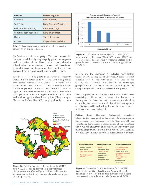
Figure 11. Influence of Hydrologic Soil Group (HSG)<br />
on groundwater Recharge (2046-2065 minus 1971-1990).<br />
HSG was one of two sensitivity attributes applied to the<br />
groundwa ter resource issue in the Chequamegon-Nicolet<br />
NFs W VA.<br />
factors, and the Coconino NF selected only factors<br />
that related to management activities. A sample output<br />
(relative erosion sensitivity of subwatersheds on the<br />
GMUG NFs) is shown in Figure 10. Soil hydrologic<br />
groups used to classify watershed sensitivity on the<br />
Chequamegon-Nicolet NFs are shown in Figure 11.<br />
The Chugach NF assessment used many of the same<br />
sensitivity attributes as the other pilot Forests, but<br />
the approach differed in that the analysis consisted of<br />
comparing two watersheds with significant management<br />
activity (primarily undeveloped watersheds or those in<br />
wilderness were not included).<br />
Ratings from National Watershed Condition<br />
Classification were used in the sensitivity evaluation by<br />
the Coconino and Gallatin NFs. The Coconino NF was<br />
completing the Condition Classification at the same time<br />
the WVA was underway, and staff realized the utility that<br />
data developed would have in both efforts. The Coconino<br />
NF used few intrinsic factors to characterize watershed<br />
Aquatic Biological<br />
Life Form Presence<br />
Native Species<br />
Exotic and or Invasive<br />
Species<br />
(Riparian) Vegetation<br />
Condition<br />
Terrestrial Physical<br />
Density<br />
Road Maintenance<br />
Proximity to Water<br />
Mass Wasting<br />
Soil Productivity<br />
Soil Erosion<br />
Soil Contamination<br />
Terrestrial Biological<br />
Fire Condition Class<br />
Wildfire Effects<br />
Loss of Forest Cover<br />
(Rangeland) Vegetation<br />
Condition<br />
(Riparian) Invasive<br />
Condition<br />
(Forest) Insects<br />
and Disease<br />
Figure 12. Watershed Condition Factors from the USFS<br />
Watershed Condition Classification. Aquatic-Physical<br />
attributes are not included. Factors shown in red are those<br />
used as sensitivity indicators in the Coconino NF WVA.