

watervulnerability
watervulnerability
watervulnerability

You also want an ePaper? Increase the reach of your titles
YUMPU automatically turns print PDFs into web optimized ePapers that Google loves.
Umatilla National Forest Watershed Vulnerability Assessment, Pacific Northwest Region (R6)<br />
OBJECTIVES AND SCALE OF ANALYSIS<br />
Forestwide “Coarse Grain” Analysis<br />
The objective is to produce a display for resource managers showing the relative vulnerability of Forest<br />
watersheds to risks posed by climate change, and identify watersheds containing water “values,”<br />
(systems) that may be susceptible to changes in hydrologic conditions (Hurd 1999; Furniss et al. 2010).<br />
The analysis framework was outlined by the WVA steering committee and 12 pilot Forests with the<br />
overall goal of producing case studies with examples and a framework for National Forest watershed<br />
vulnerability assessments.<br />
The analysis scale was Forestwide at the subwatershed unit (12-digit hydrologic unit, or HU12). A total<br />
of 162 HU12 watersheds contain UNF acres; of these, 101 have 25% or more UNF acres where data and<br />
results are most representative. This scale was intended to provide an overview of the Forest, to<br />
distinguish relative vulnerability from place to place based on water resource values and non-climate<br />
sensitivity (resilience, condition, threats). The climate data resolution was not detailed enough for HU12level<br />
analysis, so data were summarized at the HU10 (watershed) scale and applied uniformly to<br />
subwatersheds contained within.<br />
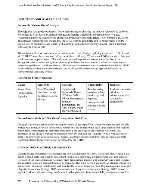
Generalized Framework Steps<br />
Values Sensitivity Exposure Vulnerability Response<br />
Water Uses,<br />
Infrastructure,<br />
Aquatics<br />
Base Watershed<br />
Condition ratings,<br />
Resiliency factors,<br />
Threats<br />
Historic and<br />
Projected Climate<br />
(2030 and 2070)<br />
Winter Temperature,<br />
Summer<br />
Temperature, and<br />
April 1 Snow water<br />
equivalent (SWE)<br />
Focused Watersheds or “Fine Grain” Analysis for Bull Trout<br />
212 Assessing the Vulnerability of Watersheds to Climate Change<br />
Relative rating<br />
based on values,<br />
sensitivity, and<br />
exposure.<br />
Composite and<br />
individual value<br />
ratings<br />
Evaluate restoration<br />
priorities,<br />
infrastructure risk,<br />
community<br />
engagement<br />
Our goal was to develop an understanding of climate change specific to water temperatures and suitable<br />
critical bull trout (Salvelinus confluentus) habitat on a HU10 forestwide scale. The analysis was focused<br />
within HU12 subwatersheds in the three bull trout ESU subareas on the Umatilla NF (John Day,<br />
Tucannon in the Snake River and Washington recovery unit, and the Umatilla - Walla Walla recovery<br />
unit). The aim was to delineate historic, current, and future suitable bull trout habitat using a multiple<br />
regression stream temperature model developed by the RMRS.<br />
CONNECTION TO OTHER ASSESSMENTS<br />
Climate change vulnerability assessments are now a component of USDA’s Strategic Plan. Region 6 has<br />
begun a broad-scale vulnerability assessment for multiple resources, including water uses and aquatics.<br />
Revision of the Blue Mountains National Forest management plans is well underway and water resource<br />
and aquatics issues are important aspects of planning. The Draft Forest plan identifies climate change as a<br />
management challenge both broadly and specifically to water resources. Two Regional aquatics strategies<br />
(Aquatic Restoration Strategy, 2005, and Aquatic and Riparian Conservation Strategy, 2008) do not<br />
explicitly address climate change implications, although results from vulnerability assessments could be