

watervulnerability
watervulnerability
watervulnerability

Create successful ePaper yourself
Turn your PDF publications into a flip-book with our unique Google optimized e-Paper software.
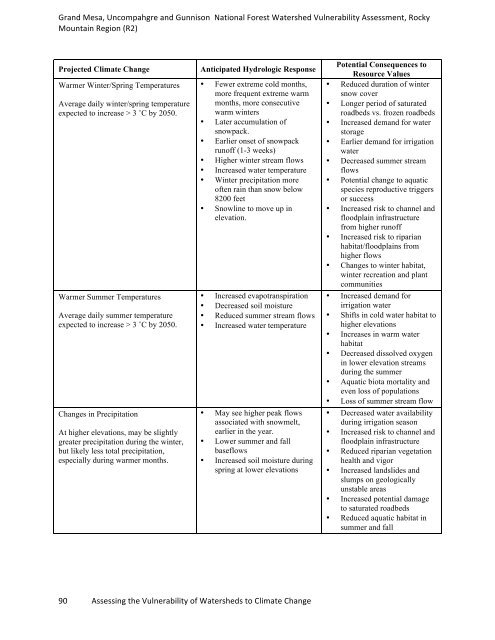
Grand Mesa, Uncompahgre and Gunnison National Forest Watershed Vulnerability Assessment, Rocky<br />
Mountain Region (R2)<br />
Projected Climate Change Anticipated Hydrologic Response<br />
Warmer Winter/Spring Temperatures<br />
Average daily winter/spring temperature<br />
expected to increase > 3 ˚C by 2050.<br />
Warmer Summer Temperatures<br />
Average daily summer temperature<br />
expected to increase > 3 ˚C by 2050.<br />
Changes in Precipitation<br />
At higher elevations, may be slightly<br />
greater precipitation during the winter,<br />
but likely less total precipitation,<br />
especially during warmer months.<br />
• Fewer extreme cold months,<br />
more frequent extreme warm<br />
months, more consecutive<br />
warm winters<br />
• Later accumulation of<br />
snowpack.<br />
• Earlier onset of snowpack<br />
runoff (1-3 weeks)<br />
• Higher winter stream flows<br />
• Increased water temperature<br />
• Winter precipitation more<br />
often rain than snow below<br />
8200 feet<br />
• Snowline to move up in<br />
elevation.<br />
• Increased evapotranspiration<br />
• Decreased soil moisture<br />
• Reduced summer stream flows<br />
• Increased water temperature<br />
• May see higher peak flows<br />
associated with snowmelt,<br />
earlier in the year.<br />
• Lower summer and fall<br />
baseflows<br />
• Increased soil moisture during<br />
spring at lower elevations<br />
90 Assessing the Vulnerability of Watersheds to Climate Change<br />
Potential Consequences to<br />
Resource Values<br />
• Reduced duration of winter<br />
snow cover<br />
• Longer period of saturated<br />
roadbeds vs. frozen roadbeds<br />
• Increased demand for water<br />
storage<br />
• Earlier demand for irrigation<br />
water<br />
• Decreased summer stream<br />
flows<br />
• Potential change to aquatic<br />
species reproductive triggers<br />
or success<br />
• Increased risk to channel and<br />
floodplain infrastructure<br />
from higher runoff<br />
• Increased risk to riparian<br />
habitat/floodplains from<br />
higher flows<br />
• Changes to winter habitat,<br />
winter recreation and plant<br />
communities<br />
• Increased demand for<br />
irrigation water<br />
• Shifts in cold water habitat to<br />
higher elevations<br />
• Increases in warm water<br />
habitat<br />
• Decreased dissolved oxygen<br />
in lower elevation streams<br />
during the summer<br />
• Aquatic biota mortality and<br />
even loss of populations<br />
• Loss of summer stream flow<br />
• Decreased water availability<br />
during irrigation season<br />
• Increased risk to channel and<br />
floodplain infrastructure<br />
• Reduced riparian vegetation<br />
health and vigor<br />
• Increased landslides and<br />
slumps on geologically<br />
unstable areas<br />
• Increased potential damage<br />
to saturated roadbeds<br />
• Reduced aquatic habitat in<br />
summer and fall