

watervulnerability
watervulnerability
watervulnerability

Create successful ePaper yourself
Turn your PDF publications into a flip-book with our unique Google optimized e-Paper software.
Sawtooth National Forest Watershed Vulnerability Assessment, Intermountain Region (R4)<br />
Overall, the predictions for bull trout do not seem promising for long-term persistence for many<br />
populations. The long-term climate patterns in tributary streams suggest both an expected decrease in the<br />
total amount of cold water stream habitat and fragmentation of some colder areas into disconnected<br />
“patches” of suitable habitat. Bull trout populations will likely increasingly retreat into these shrinking<br />
summer cold water refuges to avoid warming conditions. These restricted tributary populations may<br />
become more vulnerable to local extinction (Dunham et al. 1997; Dunham and Rieman 1999; Morita and<br />
Yamamoto 2002; Rich et al. 2003; Isaak et al. 2007). Many remaining patches will be subjected to more<br />
frequent winter peak flows, which will scour the streambed and destroy redds and/or kill newly emerged<br />
fry. Populations may also be subjected to larger, more severe wildfires (McKenzie et al. 2004; Westerling<br />
et al. 2006) that can remove riparian vegetation or catalyze severe channel disturbances such as debris<br />
flows (Luce, et al 2005). Conceivably, the combined effects of shrinking patch size and increasing<br />
frequency or magnitude of stream channel disturbance could chip away at what remaining resiliency these<br />
populations have, leaving them in a poorer condition to withstand the next series of disturbances, and<br />
accelerating the rate of local extinctions beyond that driven by temperature alone.<br />
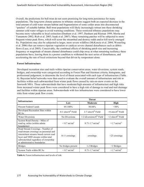
Forest Infrastructure<br />
Developed recreation sites and trails within riparian conservation areas, water diversions, system roads,<br />
bridges, and ownership were categorized according to Forest Plan and literature criteria, histograms, and<br />
professional judgement, to determine the level of threat associated with each type of infrastructure (Table<br />
6). Bayesian belief networks were then used to evaluate the overall amount of infrastructure and risk to<br />
facilities within each subwatershed from winter peak flows caused by rain-on-snow events on the<br />
Sawtooth NRA. Those subwatersheds that have moderate/high amounts of infrastructure and high risks<br />
from increased winter peak flows were considered to have a high risk of damage to road and trail drainage<br />
and facilities within riparian areas. Subwatersheds with less infrastructure were considered to have lower<br />
risks from winter peak flow events.<br />
Infrastructure<br />
Low<br />
Threat<br />
Moderate High<br />
Percent Federal Lands 85-100% 50-84% 8 sites/6 th Field<br />
Water Diversions No Diversions 1-2 diversions/6 th Field >2 sites/6 th System Road Density - Miles of<br />
Field<br />
road/sq. miles (within admin<br />
boundaries)<br />
< 0.7 mi/mi 2 0.71-1.7 mi/mi 2 >1.7 mi/mi 2<br />
Road Stream Crossings - Number of<br />
road/stream crossings on perennial and<br />
intermittent streams based current road<br />
layer and NHD streams within total<br />
subwatershed regardless of ownership<br />
or administrative boundaries<br />
0-11 crossings crossings >23 crossings<br />
Bridges No bridges present 1-2 Bridges >2 Bridges<br />
System Trails within RCAs < 0.7 mi/mi 2 0.71-1.7 mi/mi 2 >1.7 mi/mi 2<br />
Table 6. Forest infrastructure and levels of risk<br />
177 Assessing the Vulnerability of Watersheds to Climate Change