- Page 1 and 2: ILLUSTRATED FLORA OF EAST TEXAS
- Page 3 and 4: ALLDREDGE, LINDA & JACK BATTERBAE,
- Page 5 and 6: We would like to recognize and expr
- Page 7 and 8: ISSN 0833-1475 ISBN 1-889878-12-X S
- Page 9 and 10: “DEEP EAST TEXAS IS AN OLD, QUIET
- Page 11 and 12: Elray S. Nixon E lray Nixon was bor
- Page 13 and 14: ILLUSTRATED FLORA OF EAST TEXAS TAB
- Page 15 and 16: TABLE OFCONTENTS/ PAGE APPENDICES A
- Page 17 and 18: Hymenocallis liriosme
- Page 19 and 20: ILLUSTRATED FLORA OF EAST TEXAS OVE
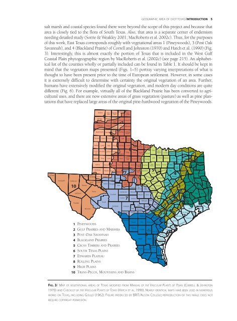
- Page 21: 4 INTRODUCTION/GEOGRAPHIC AREA OF E
- Page 25 and 26: 8 INTRODUCTION/GEOGRAPHIC AREA OF E
- Page 27 and 28: 10 INTRODUCTION/MAJOR RIVERS OF EAS
- Page 29 and 30: 12 INTRODUCTION/PLANTS TREATED The
- Page 31 and 32: 14 INTRODUCTION/GUIDE TO ARRANGEMEN
- Page 33 and 34: 16 INTRODUCTION/GUIDE TO SOURCES OF
- Page 35 and 36: 18 INTRODUCTION/GUIDE TO GEOGRAPHIC
- Page 37 and 38: 20 INTRODUCTION/GUIDE TO ENDANGERED
- Page 39 and 40: 22 INTRODUCTION/GUIDE TO GLOSSARY,
- Page 41 and 42: 24 INTRODUCTION/GUIDE TO ABBREVIATI
- Page 43 and 44: 26 INTRODUCTION/SUMMARY DATA ON FLO
- Page 45 and 46: 28 INTRODUCTION/ACKNOWLEDGMENTS Kar
- Page 47 and 48: 30 INTRODUCTION/AUTHORS’ NOTE Pre
- Page 49 and 50: 32 INTRODUCTION/GENERAL GEOLOGY OF
- Page 51 and 52: 34 INTRODUCTION/GENERAL GEOLOGY OF
- Page 53 and 54: 36 INTRODUCTION/GENERAL GEOLOGY OF
- Page 55 and 56: 38 INTRODUCTION/GENERAL GEOLOGY OF
- Page 57 and 58: 40 INTRODUCTION/GENERAL GEOLOGY OF
- Page 59 and 60: 42 INTRODUCTION/GENERAL GEOLOGY OF
- Page 61 and 62: 44 INTRODUCTION/GENERAL GEOLOGY OF
- Page 63 and 64: 46 INTRODUCTION/SOILS SOIL ORDER DE
- Page 65 and 66: 48 INTRODUCTION/SOILS, EAST TEXAS B
- Page 67 and 68: 50 INTRODUCTION/SOIL-RELATED GEOLOG
- Page 69 and 70: 52 INTRODUCTION/SOIL-RELATED GEOLOG
- Page 71 and 72: 54 INTRODUCTION/SOIL-RELATED GEOLOG
- Page 73 and 74:
56 INTRODUCTION/SOIL-RELATED GEOLOG
- Page 75 and 76:
58 INTRODUCTION/SOIL-RELATED GEOLOG
- Page 77 and 78:
60 INTRODUCTION/SOILS OF BLACKLAND
- Page 79 and 80:
62 INTRODUCTION/SOILS OF BLACKLAND
- Page 81 and 82:
64 INTRODUCTION/SOILS OF BLACKLAND
- Page 83 and 84:
66 INTRODUCTION/CLIMATE OF EAST TEX
- Page 85 and 86:
68 INTRODUCTION/CLIMATE OF EAST TEX
- Page 87 and 88:
70 INTRODUCTION/CLIMATE OF EAST TEX
- Page 89 and 90:
72 INTRODUCTION/CLIMATE OF EAST TEX
- Page 91 and 92:
74 INTRODUCTION/CLIMATE OF EAST TEX
- Page 93 and 94:
Forests define East Texas, and to a
- Page 95 and 96:
78 INTRODUCTION/GEOLOGY OF PINEYWOO
- Page 97 and 98:
80 INTRODUCTION/PRESETTLEMENT, EARL
- Page 99 and 100:
82 INTRODUCTION/PRESETTLEMENT, EARL
- Page 101 and 102:
84 INTRODUCTION/PRESETTLEMENT, EARL
- Page 103 and 104:
86 INTRODUCTION/PRESETTLEMENT, EARL
- Page 105 and 106:
88 INTRODUCTION/PRESETTLEMENT VEGET
- Page 107 and 108:
90 INTRODUCTION/CURRENT VEGETATION
- Page 109 and 110:
92 INTRODUCTION/CURRENT VEGETATION
- Page 111 and 112:
94 INTRODUCTION/CURRENT VEGETATION
- Page 113 and 114:
96 INTRODUCTION/CURRENT VEGETATION
- Page 115 and 116:
98 INTRODUCTION/CURRENT VEGETATION
- Page 117 and 118:
100 INTRODUCTION/CURRENT VEGETATION
- Page 119 and 120:
102 INTRODUCTION/CURRENT VEGETATION
- Page 121 and 122:
104 INTRODUCTION/CURRENT VEGETATION
- Page 123 and 124:
106 INTRODUCTION/POST OAK SAVANNAH
- Page 125 and 126:
108 INTRODUCTION/POST OAK SAVANNAH
- Page 127 and 128:
110 INTRODUCTION/GEOLOGY AND SOILS
- Page 129 and 130:
112 INTRODUCTION/SOILS, FIRE, AND T
- Page 131 and 132:
114 INTRODUCTION/SOILS, FIRE, AND T
- Page 133 and 134:
116 INTRODUCTION/ PRESETTLEMENT, EA
- Page 135 and 136:
118 INTRODUCTION/VEGETATION OF POST
- Page 137 and 138:
120 INTRODUCTION/VEGETATION OF POST
- Page 139 and 140:
122 INTRODUCTION/VEGETATION OF POST
- Page 141 and 142:
124 INTRODUCTION/CONDITIONS TODAY O
- Page 143 and 144:
126 INTRODUCTION/POST OAK SAVANNAH
- Page 145 and 146:
128 INTRODUCTION/RED RIVER AREA are
- Page 147 and 148:
130 INTRODUCTION/BLACKLAND PRAIRIE
- Page 149 and 150:
132 INTRODUCTION/GEOLOGY OF BLACKLA
- Page 151 and 152:
134 INTRODUCTION/PRESETTLEMENT AND
- Page 153 and 154:
136 INTRODUCTION/PRESETTLEMENT AND
- Page 155 and 156:
138 INTRODUCTION/PRESETTLEMENT AND
- Page 157 and 158:
140 INTRODUCTION/PRESETTLEMENT AND
- Page 159 and 160:
142 INTRODUCTION/PRESETTLEMENT AND
- Page 161 and 162:
144 INTRODUCTION/VEGETATION OF BLAC
- Page 163 and 164:
146 INTRODUCTION/FUTURE OF BLACKLAN
- Page 165 and 166:
148 INTRODUCTION/FUTURE OF BLACKLAN
- Page 167 and 168:
150 INTRODUCTION/CADDO LAKE LOCATIO
- Page 169 and 170:
152 INTRODUCTION/CADDO LAKE FIG.84/
- Page 171 and 172:
154 INTRODUCTION/PRESENT AND FUTURE
- Page 173 and 174:
156 INTRODUCTION/BIG THICKET THE BI
- Page 175 and 176:
158 INTRODUCTION/BIG THICKET GEOGRA
- Page 177 and 178:
160 INTRODUCTION/NATURAL HISTORY OF
- Page 179 and 180:
162 INTRODUCTION/NATURAL HISTORY OF
- Page 181 and 182:
164 INTRODUCTION/NATURAL HISTORY OF
- Page 183 and 184:
166 INTRODUCTION/NATURAL HISTORY OF
- Page 185 and 186:
168 INTRODUCTION/NATURAL HISTORY OF
- Page 187 and 188:
170 INTRODUCTION/NATURAL HISTORY OF
- Page 189 and 190:
172 INTRODUCTION/SUMMARY DEFINITION
- Page 191 and 192:
174 INTRODUCTION/PRESETTLEMENT AND
- Page 193 and 194:
176 INTRODUCTION/PRESETTLEMENT AND
- Page 195 and 196:
178 INTRODUCTION/PRESETTLEMENT AND
- Page 197 and 198:
180 INTRODUCTION/PRESETTLEMENT AND
- Page 199 and 200:
182 INTRODUCTION/PRESETTLEMENT AND
- Page 201 and 202:
184 INTRODUCTION/HISTORY OF BIG THI
- Page 203 and 204:
186 INTRODUCTION/HISTORY OF BIG THI
- Page 205 and 206:
188 INTRODUCTION/HISTORY OF BIG THI
- Page 207 and 208:
190 INTRODUCTION/CONSERVATION IN BI
- Page 209 and 210:
192 INTRODUCTION/CONSERVATION IN BI
- Page 211 and 212:
194 INTRODUCTION/CONSERVATION IN BI
- Page 213 and 214:
196 INTRODUCTION/CONSERVATION IN BI
- Page 215 and 216:
198 INTRODUCTION/CONSERVATION IN BI
- Page 217 and 218:
200 INTRODUCTION/ORIGIN AND DIVERSI
- Page 219 and 220:
202 INTRODUCTION/ORIGIN AND DIVERSI
- Page 221 and 222:
204 INTRODUCTION/ORIGIN AND DIVERSI
- Page 223 and 224:
206 INTRODUCTION/ORIGIN AND DIVERSI
- Page 225 and 226:
208 INTRODUCTION/ORIGIN AND DIVERSI
- Page 227 and 228:
210 INTRODUCTION/ORIGIN AND DIVERSI
- Page 229 and 230:
212 INTRODUCTION/ORIGIN AND DIVERSI
- Page 231 and 232:
214 INTRODUCTION/ORIGIN AND DIVERSI
- Page 233 and 234:
216 INTRODUCTION/ORIGIN AND DIVERSI
- Page 235 and 236:
218 INTRODUCTION/ORIGIN AND DIVERSI
- Page 237 and 238:
220 INTRODUCTION/ORIGIN AND DIVERSI
- Page 239 and 240:
222 INTRODUCTION/ORIGIN AND DIVERSI
- Page 241 and 242:
224 INTRODUCTION/ORIGIN AND DIVERSI
- Page 243 and 244:
226 INTRODUCTION/ORIGIN AND DIVERSI
- Page 245 and 246:
228 INTRODUCTION/CONSERVATION IN EA
- Page 247 and 248:
230 INTRODUCTION/CONSERVATION IN EA
- Page 249 and 250:
232 INTRODUCTION/CONSERVATION IN EA
- Page 251 and 252:
234 INTRODUCTION/HISTORY OF BOTANY
- Page 253 and 254:
236 INTRODUCTION/HISTORY OF BOTANY
- Page 255 and 256:
238 INTRODUCTION/HISTORY OF BOTANY
- Page 257 and 258:
240 INTRODUCTION/HISTORY OF BOTANY
- Page 259 and 260:
242 INTRODUCTION/HISTORY OF BOTANY
- Page 261 and 262:
244 INTRODUCTION/BOTANY IN NORTH CE
- Page 263 and 264:
246 INTRODUCTION/BOTANY IN NORTH CE
- Page 265 and 266:
248 INTRODUCTION/BOTANY AT UNIVERSI
- Page 267 and 268:
250 INTRODUCTION/BOTANY AT TEXAS A&
- Page 269 and 270:
252 INTRODUCTION/BOTANY AT TEXAS A&
- Page 271 and 272:
254 INTRODUCTION/OTHER CONTRIBUTION
- Page 273 and 274:
256 INTRODUCTION/CURRENT BOTANICAL
- Page 275 and 276:
258 INTRODUCTION/BOTANICAL ART IN E
- Page 277 and 278:
260 INTRODUCTION/BOTANICAL ART IN E
- Page 279 and 280:
262 INTRODUCTION/BOTANICAL ART IN E
- Page 281 and 282:
264 INTRODUCTION/BOTANICAL ART IN E
- Page 283 and 284:
266 INTRODUCTION/BOTANICAL ART IN E
- Page 285 and 286:
268 INTRODUCTION/BOTANICAL ART IN E
- Page 287 and 288:
270 INTRODUCTION/BOTANICAL ART IN E