

ILLUSTRATED FLORA OF EAST TEXAS - Brit - Botanical Research ...
ILLUSTRATED FLORA OF EAST TEXAS - Brit - Botanical Research ...
ILLUSTRATED FLORA OF EAST TEXAS - Brit - Botanical Research ...

You also want an ePaper? Increase the reach of your titles
YUMPU automatically turns print PDFs into web optimized ePapers that Google loves.
23 Arizona/New Mexico Mountains<br />
23a Chihuahuan Desert Slopes<br />
23b Montane Woodlands<br />
24 Chihuahuan Deserts<br />
24a Chihuahuan Basins and Playas<br />
24b Chihuahuan Desert Grasslands<br />
24c Low Mountains and Bajadas<br />
24d Chihuahuan Montane Woodlands<br />
24e Stockton Plateau<br />
25 High Plains<br />
25b Rolling Sand Plains<br />
25e Canadian/Cimarron High Plains<br />
25i Llano Estacado<br />
25j Shinnery Sands<br />
25k Arid Llano Estacado<br />
25b 26a<br />
25b<br />
25e<br />
26 Southwestern Tablelands<br />
26a Canadian/Cimarron Breaks<br />
26b Flat Tablelands and Valleys<br />
26c Caprock Canyons, Badlands, and Breaks<br />
26d Semiarid Canadian Breaks<br />
27 Central Great Plains<br />
27h Red Prairie<br />
27i Broken Red Plains<br />
27j Limestone Plains<br />
29 Cross Timbers<br />
29b Eastern Cross Timbers<br />
29c Western Cross Timbers<br />
29d Grand Prairie<br />
29e Limestone Cut Plain<br />
29f Carbonate Cross Timbers<br />
26a<br />
GEOGRAPHIC AREA <strong>OF</strong> <strong>EAST</strong> <strong>TEXAS</strong>/INTRODUCTION 7<br />
30 Edwards Plateau<br />
30a Edwards Plateau Woodland<br />
30b Llano Uplift<br />
30c Balcones Canyonlands<br />
30d Semiarid Edwards Plateau<br />
31 Southern Texas Plains<br />
31a Northern Nueces Alluvial Plains<br />
31b Semiarid Edwards Bajada<br />
31c Texas-Tamaulipan Thornscrub<br />
31d Rio Grande Floodplain and Terraces<br />
26d<br />
30 0 60 120 mi<br />
26a<br />
Amarillo 27h<br />
60 0 120 240 km<br />
26c<br />
27h<br />
Albers equal area projection<br />
25i<br />
26b<br />
25j<br />
27h<br />
35g<br />
Lubbock<br />
25j<br />
26b<br />
26c<br />
35g<br />
Wichita 29b<br />
35a 35c<br />
Falls<br />
27i 29d Sherman 33d<br />
35a<br />
Denton 32a 33d<br />
35c<br />
33f 35b<br />
25j<br />
24c<br />
23a<br />
Midland<br />
El Paso 24a 23b<br />
Odessa<br />
24a 24b 25k<br />
24d Pecos 25j<br />
24c<br />
24d<br />
24a<br />
24d<br />
24e<br />
24d<br />
24d<br />
24d 24e<br />
24b 24d<br />
24b<br />
24c<br />
24d 24b<br />
24c<br />
32 Texas Blackland Prairies<br />
26b<br />
27h<br />
26b Abilene<br />
26c 30d<br />
27j<br />
San Angelo<br />
30d<br />
30a<br />
24a<br />
31b<br />
Del Rio<br />
31a<br />
31d<br />
Dallas 33f 35a 35b<br />
29f Fort<br />
35b<br />
Worth<br />
33a<br />
32c<br />
Tyler<br />
29b<br />
29c<br />
35b<br />
35a<br />
33f 35b Nacogdoches<br />
Waco<br />
29e 32c<br />
33b 35b 35e<br />
Temple<br />
33f<br />
33C<br />
35b<br />
35e<br />
30b 32a<br />
35f<br />
35f 35b<br />
Austin 33b<br />
35f 35b<br />
34a<br />
32c 33e 32b<br />
32c<br />
34a<br />
30c<br />
33f 34a<br />
Houston 34g<br />
San 32b 34a<br />
Antonio<br />
Galveston<br />
34a<br />
34c 34c<br />
33b Victoria 34a 34h<br />
34a<br />
32a Northern Blackland Prairie<br />
32b Southern Blackland/Fayette Prairie<br />
32c Floodplains and Low Terraces<br />
31c<br />
34b<br />
34c<br />
34h<br />
34h<br />
33 East Central Texas Plains<br />
33a Northern Post Oak Savanna<br />
33b Southern Post Oak Savanna<br />
33c San Antonio Prairie<br />
31d<br />
Laredo<br />
34b<br />
Corpus Christi<br />
34i<br />
33d Northern Prairie Outliers<br />
33e Bastrop Lost Pines<br />
34d GULF <strong>OF</strong> MEXICO<br />
33f Floodplains and Low Terraces<br />
34 Western Gulf Coastal Plain<br />
34a Northern Humid Gulf Coastal Prairies<br />
34b Southern Subhumid Gulf Coastal Prairies<br />
34c Floodplains and Low Terraces<br />
31d<br />
34e<br />
35 South Central Plains<br />
34f 34i<br />
Brownsville<br />
34d Coastal Sand Plain<br />
35a Tertiary Uplands<br />
34e Lower Rio Grande Valley<br />
34f Lower Rio Grande Alluvial Floodplain<br />
34g Texas-Louisiana Coastal Marshes<br />
35b Floodplains and Low Terraces<br />
35c Pleistocene Fluvial Terraces<br />
35e Southern Tertiary Uplands<br />
Level III ecoregion<br />
Level IV ecoregion<br />
34h Mid-Coast Barrier Islands and Coastal Marshes 35f Flatwoods<br />
County boundary<br />
34i Laguna Madre Barrier Islands and Coastal Marshes 35g Red River Bottomlands<br />
State boundary<br />
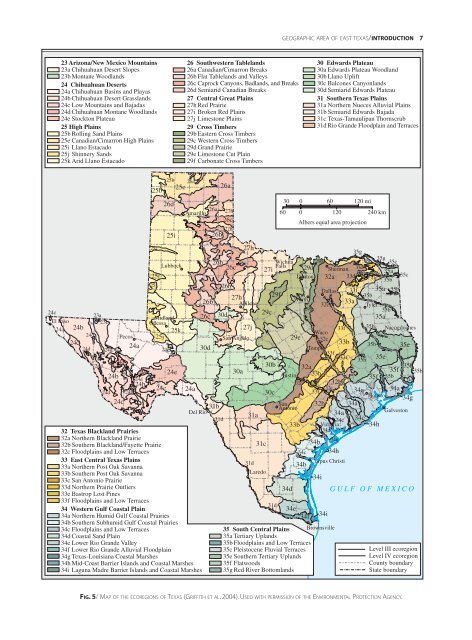
FIG.5/MAP <strong>OF</strong> THE ECOREGIONS <strong>OF</strong> <strong>TEXAS</strong> (GRIFFITH ET AL. 2004). USED WITH PERMISSION <strong>OF</strong> THE ENVIRONMENTAL PROTECTION AGENCY.<br />
33c


