- Page 1 and 2:
Papers in Australian Maritime Affai
- Page 3 and 4:
© Copyright Commonwealth of Austra
- Page 5 and 6:
disclaimer The views expressed are
- Page 7 and 8:
vi No. 13 Future Environmental Poli
- Page 9 and 10:
viii instinct ensured that even fau
- Page 11 and 12:
x Missing Pieces 4. Taking the Offe
- Page 13 and 14:
xii Maps 1. Pursuit of MV Romolo by
- Page 15 and 16:
xiv glossary In this book, place na
- Page 17 and 18:
xvi Missing Pieces CCS Combined Chi
- Page 19 and 20:
xviii Missing Pieces NGS Naval Gunf
- Page 22 and 23:
introduction By ‘intelligence’
- Page 24 and 25:
inTROducTiOn commander’s requirem
- Page 26 and 27:
Figure 2 - Desirable Intelligence f
- Page 28 and 29:
inTROducTiOn Sigint involves the in
- Page 30 and 31:
inTROducTiOn In her study of the ca
- Page 32 and 33:
1. setting the scene - The Ran and
- Page 34 and 35:
seTTing The scene - The Ran and iTs
- Page 36 and 37:
seTTing The scene - The Ran and iTs
- Page 38 and 39:
seTTing The scene - The Ran and iTs
- Page 40 and 41:
seTTing The scene - The Ran and iTs
- Page 42 and 43:
seTTing The scene - The Ran and iTs
- Page 44 and 45:
2. Operations against italy, Vichy
- Page 46 and 47:
Pursuit of MV Romolo, June 1940 OPe
- Page 48 and 49:
OPeRaTiOns againsT iTaly, Vichy FRa
- Page 50 and 51:
OPeRaTiOns againsT iTaly, Vichy FRa
- Page 52 and 53:
OPeRaTiOns againsT iTaly, Vichy FRa
- Page 54 and 55:
OPeRaTiOns againsT iTaly, Vichy FRa
- Page 56 and 57:
OPeRaTiOns againsT iTaly, Vichy FRa
- Page 58 and 59:
OPeRaTiOns againsT iTaly, Vichy FRa
- Page 60 and 61:
OPeRaTiOns againsT iTaly, Vichy FRa
- Page 62 and 63:
OPeRaTiOns againsT iTaly, Vichy FRa
- Page 64 and 65:
OPeRaTiOns againsT iTaly, Vichy FRa
- Page 66 and 67:
OPeRaTiOns againsT iTaly, Vichy FRa
- Page 68 and 69:
OPeRaTiOns againsT iTaly, Vichy FRa
- Page 70 and 71:
3. Facing the Japanese Onslaught, 1
- Page 72 and 73:
Facing The JaPanese OnslaughT 1941-
- Page 74 and 75:
Facing The JaPanese OnslaughT 1941-
- Page 76 and 77:
Facing The JaPanese OnslaughT 1941-
- Page 78 and 79:
Facing The JaPanese OnslaughT 1941-
- Page 80 and 81:
Facing The JaPanese OnslaughT 1941-
- Page 82 and 83:
Facing The JaPanese OnslaughT 1941-
- Page 84 and 85:
Facing The JaPanese OnslaughT 1941-
- Page 86 and 87:
Facing The JaPanese OnslaughT 1941-
- Page 88 and 89:
Facing The JaPanese OnslaughT 1941-
- Page 90 and 91: Facing The JaPanese OnslaughT 1941-
- Page 92 and 93: Facing The JaPanese OnslaughT 1941-
- Page 94 and 95: Facing The JaPanese OnslaughT 1941-
- Page 96 and 97: Facing The JaPanese OnslaughT 1941-
- Page 98 and 99: Facing The JaPanese OnslaughT 1941-
- Page 100 and 101: Facing The JaPanese OnslaughT 1941-
- Page 102 and 103: Facing The JaPanese OnslaughT 1941-
- Page 104 and 105: Facing The JaPanese OnslaughT 1941-
- Page 106 and 107: Facing The JaPanese OnslaughT 1941-
- Page 108 and 109: Facing The JaPanese OnslaughT 1941-
- Page 110 and 111: Facing The JaPanese OnslaughT 1941-
- Page 112 and 113: Facing The JaPanese OnslaughT 1941-
- Page 114 and 115: Facing The JaPanese OnslaughT 1941-
- Page 116 and 117: Facing The JaPanese OnslaughT 1941-
- Page 118 and 119: Facing The JaPanese OnslaughT 1941-
- Page 120 and 121: Facing The JaPanese OnslaughT 1941-
- Page 122 and 123: 4. Taking the Offensive, 1942—45
- Page 124 and 125: Taking The OFFensiVe 1942-45 Map 9
- Page 126 and 127: Taking The OFFensiVe 1942-45 Map 10
- Page 128 and 129: Taking The OFFensiVe 1942-45 treate
- Page 130 and 131: Taking The OFFensiVe 1942-45 across
- Page 132 and 133: Taking The OFFensiVe 1942-45 for ne
- Page 134 and 135: Taking The OFFensiVe 1942-45 on 15
- Page 136 and 137: Taking The OFFensiVe 1942-45 The Al
- Page 138 and 139: Taking The OFFensiVe 1942-45 during
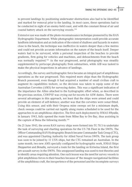
- Page 142 and 143: Taking The OFFensiVe 1942-45 At a c
- Page 144 and 145: Taking The OFFensiVe 1942-45 presen
- Page 146 and 147: Taking The OFFensiVe 1942-45 have t
- Page 148 and 149: Taking The OFFensiVe 1942-45 There
- Page 150 and 151: Taking The OFFensiVe 1942-45 A simi
- Page 152 and 153: Taking The OFFensiVe 1942-45 In the
- Page 154 and 155: Taking The OFFensiVe 1942-45 Americ
- Page 156 and 157: The bridge of HMAS Australia Taking
- Page 158 and 159: Taking The OFFensiVe 1942-45 Map 14
- Page 160 and 161: Taking The OFFensiVe 1942-45 confus
- Page 162 and 163: Taking The OFFensiVe 1942-45 W J Do
- Page 164 and 165: Taking The OFFensiVe 1942-45 guns.
- Page 166 and 167: Taking The OFFensiVe 1942-45 Barbey
- Page 168 and 169: 5. a united nations ‘Police actio
- Page 170 and 171: a uniTed naTiOns ‘POlice acTiOn
- Page 172 and 173: a uniTed naTiOns ‘POlice acTiOn
- Page 174 and 175: a uniTed naTiOns ‘POlice acTiOn
- Page 176 and 177: a uniTed naTiOns ‘POlice acTiOn
- Page 178 and 179: a uniTed naTiOns ‘POlice acTiOn
- Page 180 and 181: a uniTed naTiOns ‘POlice acTiOn
- Page 182 and 183: a uniTed naTiOns ‘POlice acTiOn
- Page 184 and 185: a uniTed naTiOns ‘POlice acTiOn
- Page 186 and 187: a uniTed naTiOns ‘POlice acTiOn
- Page 188 and 189: a uniTed naTiOns ‘POlice acTiOn
- Page 190 and 191:
a uniTed naTiOns ‘POlice acTiOn
- Page 192 and 193:
a uniTed naTiOns ‘POlice acTiOn
- Page 194 and 195:
a uniTed naTiOns ‘POlice acTiOn
- Page 196 and 197:
a uniTed naTiOns ‘POlice acTiOn
- Page 198 and 199:
a uniTed naTiOns ‘POlice acTiOn
- Page 200 and 201:
a uniTed naTiOns ‘POlice acTiOn
- Page 202 and 203:
a uniTed naTiOns ‘POlice acTiOn
- Page 204 and 205:
6. securing southeast asia: Malayan
- Page 206 and 207:
secuRing sOuTheasT asia: Malayan eM
- Page 208 and 209:
secuRing sOuTheasT asia: Malayan eM
- Page 210 and 211:
secuRing sOuTheasT asia: Malayan eM
- Page 212 and 213:
secuRing sOuTheasT asia: Malayan eM
- Page 214 and 215:
secuRing sOuTheasT asia: Malayan eM
- Page 216 and 217:
secuRing sOuTheasT asia: Malayan eM
- Page 218 and 219:
secuRing sOuTheasT asia: Malayan eM
- Page 220 and 221:
secuRing sOuTheasT asia: Malayan eM
- Page 222 and 223:
secuRing sOuTheasT asia: Malayan eM
- Page 224 and 225:
secuRing sOuTheasT asia: Malayan eM
- Page 226 and 227:
secuRing sOuTheasT asia: Malayan eM
- Page 228 and 229:
secuRing sOuTheasT asia: Malayan eM
- Page 230 and 231:
secuRing sOuTheasT asia: Malayan eM
- Page 232 and 233:
secuRing sOuTheasT asia: Malayan eM
- Page 234 and 235:
secuRing sOuTheasT asia: Malayan eM
- Page 236 and 237:
secuRing sOuTheasT asia: Malayan eM
- Page 238 and 239:
secuRing sOuTheasT asia: Malayan eM
- Page 240 and 241:
secuRing sOuTheasT asia: Malayan eM
- Page 242 and 243:
7. Propping up a domino: Vietnam, 1
- Page 244 and 245:
PROPPing uP a dOMinO: VieTnaM 1967-
- Page 246 and 247:
PROPPing uP a dOMinO: VieTnaM 1967-
- Page 248 and 249:
PROPPing uP a dOMinO: VieTnaM 1967-
- Page 250 and 251:
PROPPing uP a dOMinO: VieTnaM 1967-
- Page 252 and 253:
PROPPing uP a dOMinO: VieTnaM 1967-
- Page 254 and 255:
PROPPing uP a dOMinO: VieTnaM 1967-
- Page 256 and 257:
Map 26 - Operation MARKET TIME PROP
- Page 258 and 259:
PROPPing uP a dOMinO: VieTnaM 1967-
- Page 260 and 261:
PROPPing uP a dOMinO: VieTnaM 1967-
- Page 262 and 263:
PROPPing uP a dOMinO: VieTnaM 1967-
- Page 264 and 265:
PROPPing uP a dOMinO: VieTnaM 1967-
- Page 266 and 267:
PROPPing uP a dOMinO: VieTnaM 1967-
- Page 268 and 269:
Damage received by HMAS Hobart afte
- Page 270 and 271:
PROPPing uP a dOMinO: VieTnaM 1967-
- Page 272 and 273:
PROPPing uP a dOMinO: VieTnaM 1967-
- Page 274 and 275:
PROPPing uP a dOMinO: VieTnaM 1967-
- Page 276 and 277:
PROPPing uP a dOMinO: VieTnaM 1967-
- Page 278 and 279:
PROPPing uP a dOMinO: VieTnaM 1967-
- Page 280 and 281:
PROPPing uP a dOMinO: VieTnaM 1967-
- Page 282 and 283:
PROPPing uP a dOMinO: VieTnaM 1967-
- Page 284 and 285:
PROPPing uP a dOMinO: VieTnaM 1967-
- Page 286 and 287:
8. Final Observations and conclusio
- Page 288 and 289:
OBseRVaTiOns and cOnclusiOns Bureau
- Page 290 and 291:
OBseRVaTiOns and cOnclusiOns up the
- Page 292 and 293:
OBseRVaTiOns and cOnclusiOns level
- Page 294 and 295:
codebreaking appendix - australian
- Page 296 and 297:
aPPendix practices and personnel, b
- Page 298 and 299:
aPPendix in the chain of command of
- Page 300 and 301:
aPPendix units’ in RAAF terminolo
- Page 302 and 303:
archival Records national archives
- Page 304 and 305:
CO1022 South East Asia Department:
- Page 306 and 307:
BiBliOgRaPhy Clausewitz, Karl von,
- Page 308 and 309:
BiBliOgRaPhy Harper, Norman, A Grea
- Page 310 and 311:
BiBliOgRaPhy Maneki, Sharon, The Qu
- Page 312 and 313:
BiBliOgRaPhy Stevens, David M, A Cr
- Page 314 and 315:
BiBliOgRaPhy Murray, BS, ‘The Sea
- Page 316 and 317:
introduction 1 Karl von Clausewitz,
- Page 318 and 319:
nOTes activities of the Japanese an
- Page 320 and 321:
nOTes 64 The chart of the reconstru
- Page 322 and 323:
nOTes 98 There appears to have been
- Page 324 and 325:
nOTes 131 Burrell, Mermaids Do Exis
- Page 326 and 327:
nOTes racial superiority, and probl
- Page 328 and 329:
nOTes 191 Waller, however, did not
- Page 330 and 331:
nOTes 213 MacArthur’s reasons may
- Page 332 and 333:
nOTes 236 Puleston quoted Japanese
- Page 334 and 335:
nOTes 258 As previously noted, USN
- Page 336 and 337:
nOTes 281 The range of the aircraft
- Page 338 and 339:
nOTes 297 EB Potter & Chester W Nim
- Page 340 and 341:
nOTes Darwin. [David Jenkins, Battl
- Page 342 and 343:
nOTes of the ASW escorts to sink su
- Page 344 and 345:
nOTes 353 In gaining this intellige
- Page 346 and 347:
nOTes 380 UKNA HS1/257 — SOE Far
- Page 348 and 349:
nOTes 404 NAA MP1185/8, Item 2037/7
- Page 350 and 351:
nOTes intelligence in this area has
- Page 352 and 353:
nOTes 451 The US Sigint establishme
- Page 354 and 355:
nOTes 477 O’Neill, Strategy and D
- Page 356 and 357:
nOTes Investigations, conducted sim
- Page 358 and 359:
nOTes 528 The Communists claimed th
- Page 360 and 361:
nOTes 554 ‘Do you think in Septem
- Page 362 and 363:
securing southeast asia: Malayan em
- Page 364 and 365:
nOTes London, 2000, p. 226. Stateme
- Page 366 and 367:
nOTes 639 NAA A8580/1, Item Z1/11
- Page 368 and 369:
nOTes 668 A good impression of the
- Page 370 and 371:
nOTes 704 Later in the campaign mor
- Page 372 and 373:
nOTes requirements issued by higher
- Page 374 and 375:
nOTes Defense to establish why a pa
- Page 376 and 377:
nOTes 798 Targets fell into three c
- Page 378 and 379:
826 Commander RG Ray, RAN, (Rtd), c
- Page 380 and 381:
nOTes 856 Despite the success of th
- Page 382 and 383:
inTROducTiOn 887 In New Britain in
- Page 384 and 385:
Chin Peng, 189, 192-3 China, People
- Page 386 and 387:
i Warrego, 62, 121 Whyalla, 119, Ya
- Page 388 and 389:
l Han River operations, 168-172 nat
- Page 390 and 391:
unreadiness for Malayan Emergency,
- Page 392:
index 371


