Humminbird - Fish Finders and GPS
Humminbird - Fish Finders and GPS
Humminbird - Fish Finders and GPS

You also want an ePaper? Increase the reach of your titles
YUMPU automatically turns print PDFs into web optimized ePapers that Google loves.
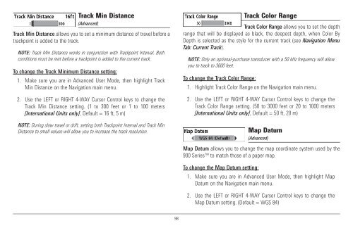
Track Min Distance<br />
(Advanced)<br />
Track Min Distance allows you to set a minimum distance of travel before a<br />
trackpoint is added to the track.<br />
NOTE: Track Min Distance works in conjunction with Trackpoint Interval. Both<br />
conditions must be met before a trackpoint is added to the current track.<br />
To change the Track Minimum Distance setting:<br />
1. Make sure you are in Advanced User Mode, then highlight Track<br />
Min Distance on the Navigation main menu.<br />
2. Use the LEFT or RIGHT 4-WAY Cursor Control keys to change the<br />
Track Min Distance setting. (1 to 300 feet or 1 to 100 meters<br />
[International Units only], Default = 16 ft, 5 m)<br />
NOTE: During slow travel or drift, setting both Trackpoint Interval <strong>and</strong> Track Min<br />
Distance to small values will allow you to increase the track resolution.<br />
Track Color Range<br />
Track Color Range allows you to set the depth<br />
range that will be displayed as black, the deepest depth, when Color By<br />
Depth is selected as the style for the current track (see Navigation Menu<br />
Tab: Current Track).<br />
NOTE: Only an optional-purchase transducer with a 50 kHz frequency will allow<br />
you to track to 3000 feet.<br />
To change the Track Color Range:<br />
1. Highlight Track Color Range on the Navigation main menu.<br />
2. Use the LEFT or RIGHT 4-WAY Cursor Control keys to change the<br />
Track Color Range setting. (50 to 3000 feet or 20 to 1000 meters<br />
[International Units only], Default = 50 ft, 20 m)<br />
Map Datum<br />
(Advanced)<br />
Map Datum allows you to change the map coordinate system used by the<br />
900 Series to match those of a paper map.<br />
To change the Map Datum setting:<br />
1. Make sure you are in Advanced User Mode, then highlight Map<br />
Datum on the Navigation main menu.<br />
2. Use the LEFT or RIGHT 4-WAY Cursor Control keys to change the<br />
Map Datum setting. (Default = WGS 84)<br />
98