Humminbird - Fish Finders and GPS
Humminbird - Fish Finders and GPS
Humminbird - Fish Finders and GPS

Create successful ePaper yourself
Turn your PDF publications into a flip-book with our unique Google optimized e-Paper software.
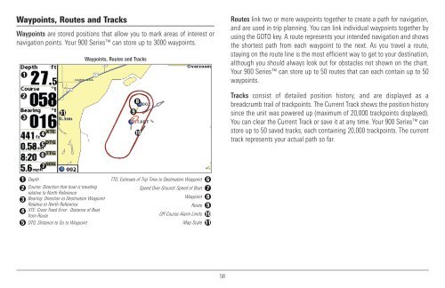
Waypoints, Routes <strong>and</strong> Tracks<br />
Waypoints are stored positions that allow you to mark areas of interest or<br />
navigation points. Your 900 Series can store up to 3000 waypoints.<br />
1<br />
Waypoints, Routes <strong>and</strong> Tracks<br />
Routes link two or more waypoints together to create a path for navigation,<br />
<strong>and</strong> are used in trip planning. You can link individual waypoints together by<br />
using the GOTO key. A route represents your intended navigation <strong>and</strong> shows<br />
the shortest path from each waypoint to the next. As you travel a route,<br />
staying on the route line is the most efficient way to get to your destination,<br />
although you should always look out for obstacles not shown on the chart.<br />
Your 900 Series can store up to 50 routes that can each contain up to 50<br />
waypoints.<br />
2<br />
3<br />
4<br />
5<br />
11 9<br />
8<br />
10<br />
Tracks consist of detailed position history, <strong>and</strong> are displayed as a<br />
breadcrumb trail of trackpoints. The Current Track shows the position history<br />
since the unit was powered up (maximum of 20,000 trackpoints displayed).<br />
You can clear the Current Track or save it at any time. Your 900 Series can<br />
store up to 50 saved tracks, each containing 20,000 trackpoints. The current<br />
track represents your actual path so far.<br />
6<br />
7<br />
1 Depth<br />
TTG: Estimate of Trip Time to Destination Waypoint 6<br />
2 Course: Direction that boat is traveling<br />
Speed Over Ground: Speed of Boat 7<br />
relative to North Reference<br />
Bearing: Direction to Destination Waypoint<br />
Waypoint<br />
3<br />
8<br />
Relative to North Reference<br />
Route 9<br />
4 XTE: Cross Track Error. Distance of Boat<br />
from Route<br />
Off-Course Alarm Limits 10<br />
5 DTG: Distance to Go to Waypoint<br />
Map Scale 11<br />
58