Humminbird - Fish Finders and GPS
Humminbird - Fish Finders and GPS
Humminbird - Fish Finders and GPS

Create successful ePaper yourself
Turn your PDF publications into a flip-book with our unique Google optimized e-Paper software.
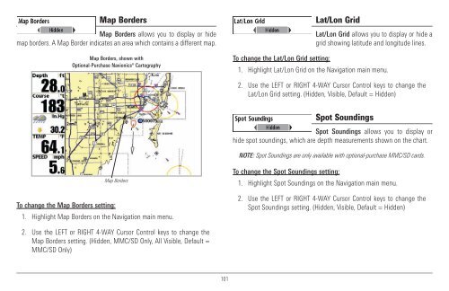
Map Borders<br />
Map Borders allows you to display or hide<br />
map borders. A Map Border indicates an area which contains a different map.<br />
Map Borders, shown with<br />
Optional-Purchase Navionics® Cartography<br />
Lat/Lon Grid<br />
Lat/Lon Grid allows you to display or hide a<br />
grid showing latitude <strong>and</strong> longitude lines.<br />
To change the Lat/Lon Grid setting:<br />
1. Highlight Lat/Lon Grid on the Navigation main menu.<br />
2. Use the LEFT or RIGHT 4-WAY Cursor Control keys to change the<br />
Lat/Lon Grid setting. (Hidden, Visible, Default = Hidden)<br />
Spot Soundings<br />
Spot Soundings allows you to display or<br />
hide spot soundings, which are depth measurements shown on the chart.<br />
NOTE: Spot Soundings are only available with optional-purchase MMC/SD cards.<br />
To change the Map Borders setting:<br />
Map Borders<br />
1. Highlight Map Borders on the Navigation main menu.<br />
To change the Spot Soundings setting:<br />
1. Highlight Spot Soundings on the Navigation main menu.<br />
2. Use the LEFT or RIGHT 4-WAY Cursor Control keys to change the<br />
Spot Soundings setting. (Hidden, Visible, Default = Hidden)<br />
2. Use the LEFT or RIGHT 4-WAY Cursor Control keys to change the<br />
Map Borders setting. (Hidden, MMC/SD Only, All Visible, Default =<br />
MMC/SD Only)<br />
101