Humminbird - Fish Finders and GPS
Humminbird - Fish Finders and GPS
Humminbird - Fish Finders and GPS

Create successful ePaper yourself
Turn your PDF publications into a flip-book with our unique Google optimized e-Paper software.
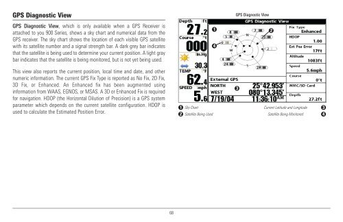
<strong>GPS</strong> Diagnostic View<br />
<strong>GPS</strong> Diagnostic View<br />
<strong>GPS</strong> Diagnostic View, which is only available when a <strong>GPS</strong> Receiver is<br />
attached to you 900 Series, shows a sky chart <strong>and</strong> numerical data from the<br />
<strong>GPS</strong> receiver. The sky chart shows the location of each visible <strong>GPS</strong> satellite<br />
with its satellite number <strong>and</strong> a signal strength bar. A dark grey bar indicates<br />
that the satellite is being used to determine your current position. A light gray<br />
bar indicates that the satellite is being monitored, but is not yet being used.<br />
1<br />
4<br />
2<br />
This view also reports the current position, local time <strong>and</strong> date, <strong>and</strong> other<br />
numeric information. The current <strong>GPS</strong> Fix Type is reported as No Fix, 2D Fix,<br />
3D Fix, or Enhanced. An Enhanced fix has been augmented using<br />
information from WAAS, EGNOS, or MSAS. A 3D or Enhanced Fix is required<br />
for navigation. HDOP (the Horizontal Dilution of Precision) is a <strong>GPS</strong> system<br />
parameter which depends on the current satellite configuration. HDOP is<br />
used to calculate the Estimated Position Error.<br />
3<br />
1 Sky Chart<br />
Current Latitude <strong>and</strong> Longitude 3<br />
2 Satellite Being Used<br />
Satellite Being Monitored 4<br />
68