Humminbird - Fish Finders and GPS
Humminbird - Fish Finders and GPS
Humminbird - Fish Finders and GPS

You also want an ePaper? Increase the reach of your titles
YUMPU automatically turns print PDFs into web optimized ePapers that Google loves.
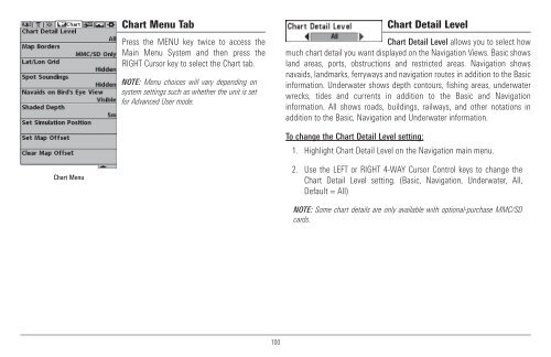
Chart Menu Tab<br />
Press the MENU key twice to access the<br />
Main Menu System <strong>and</strong> then press the<br />
RIGHT Cursor key to select the Chart tab.<br />
NOTE: Menu choices will vary depending on<br />
system settings such as whether the unit is set<br />
for Advanced User mode.<br />
Chart Detail Level<br />
Chart Detail Level allows you to select how<br />
much chart detail you want displayed on the Navigation Views. Basic shows<br />
l<strong>and</strong> areas, ports, obstructions <strong>and</strong> restricted areas. Navigation shows<br />
navaids, l<strong>and</strong>marks, ferryways <strong>and</strong> navigation routes in addition to the Basic<br />
information. Underwater shows depth contours, fishing areas, underwater<br />
wrecks, tides <strong>and</strong> currents in addition to the Basic <strong>and</strong> Navigation<br />
information. All shows roads, buildings, railways, <strong>and</strong> other notations in<br />
addition to the Basic, Navigation <strong>and</strong> Underwater information.<br />
To change the Chart Detail Level setting:<br />
1. Highlight Chart Detail Level on the Navigation main menu.<br />
Chart Menu<br />
2. Use the LEFT or RIGHT 4-WAY Cursor Control keys to change the<br />
Chart Detail Level setting. (Basic, Navigation, Underwater, All,<br />
Default = All)<br />
NOTE: Some chart details are only available with optional-purchase MMC/SD<br />
cards.<br />
100