Humminbird - Fish Finders and GPS
Humminbird - Fish Finders and GPS
Humminbird - Fish Finders and GPS

You also want an ePaper? Increase the reach of your titles
YUMPU automatically turns print PDFs into web optimized ePapers that Google loves.
Universal Sonar 2<br />
Your 900 Series <strong>Fish</strong>ing System supports Universal Sonar 2, a state-of-theart,<br />
integrated <strong>and</strong> protected transducer that is built into the lower unit of<br />
Minnkota trolling motors. With Universal Sonar 2, all wiring is concealed<br />
inside the indestructible composite shaft—out of sight <strong>and</strong> out of harm’s<br />
way, with no clamps, ties, or exposed wires. Universal Sonar 2 features new<br />
temperature sensing <strong>and</strong> the performance of DualBeam PLUS technology.<br />
An exp<strong>and</strong>ed view <strong>and</strong> greater bottom detail gives you a totally new<br />
perspective of the water below, along with optimal sonar performance to<br />
help you find fish.<br />
How <strong>GPS</strong> <strong>and</strong> Cartography Work<br />
Your 900 Series <strong>Fish</strong>ing System also supports <strong>GPS</strong> <strong>and</strong> chartplotting, <strong>and</strong><br />
uses <strong>GPS</strong> <strong>and</strong> sonar to determine your position, display it on a grid, <strong>and</strong><br />
provide detailed underwater information. The Global Positioning System<br />
(<strong>GPS</strong>) is a satellite navigation system designed <strong>and</strong> maintained by the U.S.<br />
Department of Defense. <strong>GPS</strong> was originally intended for military use;<br />
however, civilians may also take advantage of its highly accurate position<br />
capabilities, typically within +/- 10 meters, depending on conditions. This<br />
means that 95% of the time, the <strong>GPS</strong> receiver will read a location within 10<br />
meters of your actual position. Your <strong>GPS</strong> Receiver also uses information from<br />
WAAS (the Wide Area Augmentation System), EGNOS (the European<br />
Geostationary Navigation Overlay Service), <strong>and</strong> MSAS (the MTSAT Satellite<br />
Augmentation System) satellites if they are available in your area.<br />
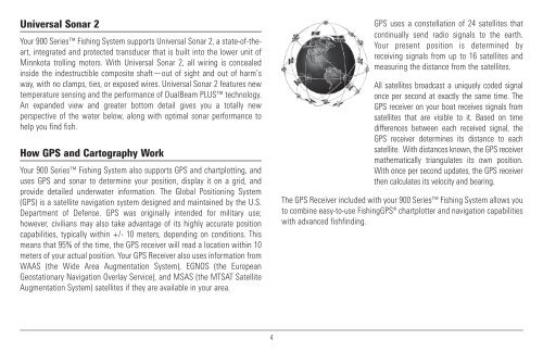
<strong>GPS</strong> uses a constellation of 24 satellites that<br />
continually send radio signals to the earth.<br />
Your present position is determined by<br />
receiving signals from up to 16 satellites <strong>and</strong><br />
measuring the distance from the satellites.<br />
All satellites broadcast a uniquely coded signal<br />
once per second at exactly the same time. The<br />
<strong>GPS</strong> receiver on your boat receives signals from<br />
satellites that are visible to it. Based on time<br />
differences between each received signal, the<br />
<strong>GPS</strong> receiver determines its distance to each<br />
satellite. With distances known, the <strong>GPS</strong> receiver<br />
mathematically triangulates its own position.<br />
With once per second updates, the <strong>GPS</strong> receiver<br />
then calculates its velocity <strong>and</strong> bearing.<br />
The <strong>GPS</strong> Receiver included with your 900 Series <strong>Fish</strong>ing System allows you<br />
to combine easy-to-use <strong>Fish</strong>ing<strong>GPS</strong>® chartplotter <strong>and</strong> navigation capabilities<br />
with advanced fishfinding.<br />
4