Humminbird - Fish Finders and GPS
Humminbird - Fish Finders and GPS
Humminbird - Fish Finders and GPS

You also want an ePaper? Increase the reach of your titles
YUMPU automatically turns print PDFs into web optimized ePapers that Google loves.
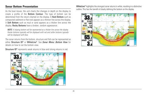
Sonar Bottom Presentation<br />
As the boat moves, the unit charts the changes in depth on the display to<br />
create a profile of the Bottom Contour. The type of bottom can be<br />
determined from the return charted on the display. A Hard Bottom such as<br />
compacted sediment or flat rock appears as a thinner line across the display.<br />
A Soft Bottom such as mud or s<strong>and</strong> appears as a thicker line across the<br />
display. Rocky Bottoms have a broken, r<strong>and</strong>om appearance.<br />
NOTE: A sloping bottom will be represented as a thicker line across the display.<br />
Harder bottoms typically will be displayed with red <strong>and</strong> softer bottoms typically<br />
will be displayed with blue.<br />
The sonar returns from the bottom, structure <strong>and</strong> fish can be represented as<br />
either Structure ID® or WhiteLine®. See Sonar Menu: Bottom View for<br />
details on how to set the bottom view.<br />
Structure ID® represents weak returns in blue <strong>and</strong> strong returns in red.<br />
WhiteLine® highlights the strongest sonar returns in white, resulting in a distinctive<br />
outline. This has the benefit of clearly defining the bottom on the display.<br />
28