HILLINGDON UNITARY DEVELOPMENT PLAN - London Borough ...
HILLINGDON UNITARY DEVELOPMENT PLAN - London Borough ...
HILLINGDON UNITARY DEVELOPMENT PLAN - London Borough ...
You also want an ePaper? Increase the reach of your titles
YUMPU automatically turns print PDFs into web optimized ePapers that Google loves.
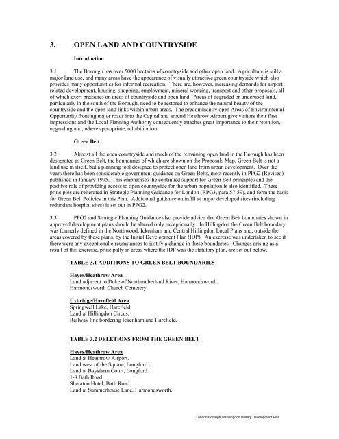
3. OPEN LAND AND COUNTRYSIDE<br />
Introduction<br />
3.1 The <strong>Borough</strong> has over 5000 hectares of countryside and other open land. Agriculture is still a<br />
major land use, and many areas have the appearance of visually attractive green countryside which also<br />
provides many opportunities for informal recreation. There are, however, increasing demands for airport<br />
related development, housing, shopping, employment, mineral working, transport and other proposals, all<br />
of which exert pressures on areas of countryside and open land. Areas of degraded or underused land,<br />
particularly in the south of the <strong>Borough</strong>, need to be restored to enhance the natural beauty of the<br />
countryside and the open land links within urban areas. The predominantly open Areas of Environmental<br />
Opportunity fronting major roads into the Capital and around Heathrow Airport give visitors their first<br />
impressions and the Local Planning Authority consequently attaches great importance to their retention,<br />
upgrading and, where appropriate, rehabilitation.<br />
Green Belt<br />
3.2 Almost all the open countryside and much of the remaining open land in the <strong>Borough</strong> has been<br />
designated as Green Belt, the boundaries of which are shown on the Proposals Map. Green Belt is not a<br />
land use in itself, but a planning tool designed to protect open land from urban development. Over the<br />
years there has been considerable government guidance on Green Belts, most recently in PPG2 (Revised)<br />
published in January 1995. This emphasises the continued support for Green Belt principles and the<br />
positive role of providing access to open countryside for the urban population is also identified. These<br />
principles are reiterated in Strategic Planning Guidance for <strong>London</strong> (RPG3, para 57-59), and form the basis<br />
for Green Belt Policies in this Plan. Additional guidance on infill at major developed sites (including<br />
redundant hospital sites) is set out in PPG2.<br />
3.3 PPG2 and Strategic Planning Guidance also provide advice that Green Belt boundaries shown in<br />
approved development plans should be altered only exceptionally. In Hillingdon the Green Belt boundary<br />
was formerly defined in the Northwood, Ickenham and Central Hillingdon Local Plans and, outside the<br />
areas covered by these plans, by the Initial Development Plan (IDP). An exercise was undertaken to see if<br />
there were any exceptional circumstances to justify a change in these boundaries. Changes arising as a<br />
result of this exercise, principally in areas where the IDP was the statutory plan, are set out below.<br />
TABLE 3.1 ADDITIONS TO GREEN BELT BOUNDARIES<br />
Hayes/Heathrow Area<br />
Land adjacent to Duke of Northumberland River, Harmondsworth.<br />
Harmondsworth Church Cemetery.<br />
Uxbridge/Harefield Area<br />
Springwell Lake, Harefield.<br />
Land at Hillingdon Circus.<br />
Railway line bordering Ickenham and Harefield.<br />
TABLE 3.2 DELETIONS FROM THE GREEN BELT<br />
Hayes/Heathrow Area<br />
Land at Heathrow Airport.<br />
Land west of the Square, Longford.<br />
Land at Baysfarm Court, Longford.<br />
1-8 Bath Road.<br />
Sheraton Hotel, Bath Road.<br />
Land at Summerhouse Lane, Harmondsworth.<br />
<strong>London</strong> <strong>Borough</strong> of Hillingdon Unitary Development Plan


