Development Plan - City of Playford - SA.Gov.au
Development Plan - City of Playford - SA.Gov.au
Development Plan - City of Playford - SA.Gov.au

You also want an ePaper? Increase the reach of your titles
YUMPU automatically turns print PDFs into web optimized ePapers that Google loves.
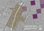
• Purdie Road/Main North Road and Medlow Road/Main North Rd intersections are to be<br />
upgraded;<br />
• a realigned Karri Street/Main North Road is a signalised 4 way intersection;<br />
• Craigmore Road/Curtis Road/Main North Road to be upgraded – Craigmore/Curtis Road will<br />
need to be 2 lanes each way;<br />
• two public primary and one private primary school sites allocated;<br />
• employment land allocated on the eastern side <strong>of</strong> Main North Rd, south <strong>of</strong> the BP service<br />
station and along a short section <strong>of</strong> Craigmore Rd;<br />
• two Neighbourhood Activity Centres and one Local Activity Centre are proposed;<br />
• the trunk watermain on Bentley Rd is to be undergrounded;<br />
• a service road to be provided <strong>of</strong>f Main North Road, to service designated employment lands;<br />
• closure <strong>of</strong> portions <strong>of</strong> Purdie, Scoular, Medlow and Bentley Roads;<br />
• road connection to land located immediately to the south, including vacant broadhectare land<br />
(recently purchased by Fairmont Homes Group) which is subject <strong>of</strong> a current 356 lot land<br />
division application;<br />
• provision <strong>of</strong> an acoustic buffer to Main North Road, in those locations where residential<br />
development will adjoin;<br />
• an open space network that includes three major linear parks which encapsulate existing creek<br />
lines and linkage to the future Medlow Rd Recreation Park and adjacent Hills Face Zone;<br />
• large (5 hectares) public open space at Main North Rd/Karri St entrance, much <strong>of</strong> which will<br />
have a detention basin/wetland function;<br />
• two further large open space areas (order <strong>of</strong> 4ha), one north <strong>of</strong> the northern most primary<br />
school site the other immediately west <strong>of</strong> the southern most primary school site which are likely<br />
to be used for active playing fields;<br />
• stormwater is dealt with (flood control and potentially water project) along existing creek lines<br />
east and west <strong>of</strong> Bentley Road;<br />
• medium density residential development to be concentrated adjacent to the two Neighbourhood<br />
Activity Centres, and fronting public open space.<br />
1.4 Existing Zoning Overview<br />
Below is an overview <strong>of</strong> the existing zones which apply to the Area Affected, including a summary<br />
<strong>of</strong> the key intent <strong>of</strong> each zone.<br />
West <strong>of</strong> Main North Road<br />
The Residential (Plains) Zone encompasses the majority <strong>of</strong> broadhectare land within the Area<br />
Affected located to the west <strong>of</strong> Main North Road. The balance <strong>of</strong> broadhectare land, located north<br />
<strong>of</strong> Fradd Road and south <strong>of</strong> Petherton Road is within the Horticulture Zone.<br />
East <strong>of</strong> Main North Road<br />
East <strong>of</strong> Main North Road, the Area Affected contains three zones, these being:<br />
• Residential (Plains);<br />
• Residential (Foothills);<br />
• Horticulture Zone– north <strong>of</strong> Medlow Road.<br />
<strong>Playford</strong> North DPA -3-<br />
Jul 08<br />
Final DPA 20 August 08.doc Version 3