Development Plan - City of Playford - SA.Gov.au
Development Plan - City of Playford - SA.Gov.au
Development Plan - City of Playford - SA.Gov.au

You also want an ePaper? Increase the reach of your titles
YUMPU automatically turns print PDFs into web optimized ePapers that Google loves.
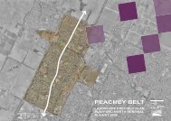
Peachey Belt<br />
There are significant sewer mains along Stebonheath Road, Petherton Road, Peachey Road,<br />
Edgecombe Road and Womma Road. There are sewer mains around the entire area including rear<br />
<strong>of</strong> allotment sewer in many areas.<br />
Based on experience in other urban renewal projects in Adelaide the increase in allotments from<br />
this area is unlikely to c<strong>au</strong>se capacity problems. Once a structure plan is developed for the area<br />
<strong>SA</strong> Water can be consulted on expected demand increases and confirm capacity issues.<br />
5.3.5 Telecommunication and Gas<br />
Telstra and Origin Energy gas services lie throughout the broad hectare areas north <strong>of</strong> Curtis Road<br />
and are likely to be sufficient to service future development. There is an Optus optic fibre which<br />
runs along the western side <strong>of</strong> the railway line.<br />
On the northern boundary <strong>of</strong> the Area Affected is the 450mm diameter SeaGas pipeline. This is<br />
currently north <strong>of</strong> Fradd Road and is not likely to impact on future development except to the extent<br />
<strong>of</strong> preventing significant widening <strong>of</strong> the Fradd Road drainage channel from the Blakeview area.<br />
There are significant underground gas mains and Telstra infrastructure along many <strong>of</strong> the major<br />
roads and will require careful consideration during design to minimize relocation costs.<br />
Where new roads are to be constructed, Telstra and Origin infrastructure will be underground within<br />
a common service trench.<br />
5.4 Transport Network<br />
5.4.1 Road Network<br />
The Area Affected is serviced by a range <strong>of</strong> road hierarchies from local residential streets to major<br />
arterial roads.<br />
Figure 5.2 below highlights the main road hierarchies within and surrounding the Area Affected.<br />
The main road hierarchies are further described as follows.<br />
Major Arterial Road:<br />
The primary arterial road servicing the Area Affected is Main North Road. It provides access to the<br />
north to Gawler, Barossa Valley and beyond and south to Elizabeth, Salisbury and the rest <strong>of</strong><br />
Metropolitan Adelaide. Volumes on Main North Road accommodates (on a 24hr basis) have been<br />
identified as follows:<br />
• 34,300 vehicles per day (vpd) at Munno Para;<br />
• 38,600 vpd at the intersection <strong>of</strong> Womma Road;<br />
• 38,100 vpd. Just south <strong>of</strong> the Curtis/Craigmore/Main North Roads intersection;<br />
• 25,700 vpd at the intersection <strong>of</strong> Smith/Dalkeith and Main North Road.<br />
The status <strong>of</strong> this road is expected to remain even with the construction <strong>of</strong> the Northern<br />
Expressway (NEXY).<br />
Minor Arterial<br />
The Area Affected is currently serviced by one minor arterial road being Womma Road. Womma<br />
Road accommodates between 6000 vpd at the intersection <strong>of</strong> Stebonheath Road and 9000 vpd at<br />
the intersection <strong>of</strong> the Gawler – Adelaide train line.<br />
Major Collector<br />
Three major Collector Roads service the Area Affected being Curtis Road, Peachey Road and<br />
Craigmore Road.<br />
<strong>Playford</strong> North DPA -68-<br />
Jul 08<br />
Final DPA 20 August 08.doc Version 3