Development Plan - City of Playford - SA.Gov.au
Development Plan - City of Playford - SA.Gov.au
Development Plan - City of Playford - SA.Gov.au

Create successful ePaper yourself
Turn your PDF publications into a flip-book with our unique Google optimized e-Paper software.
2. Facilitate transit-oriented<br />
development around selected highservice<br />
public transport routes.<br />
(a) Promote transit-oriented development<br />
and employment uses in a band <strong>of</strong><br />
activity from the Central <strong>City</strong> Activity<br />
Centre to Port Adelaide to maximise<br />
accessibility to, and make use <strong>of</strong>, that<br />
corridor’s existing transport<br />
infrastructure and services.<br />
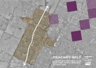
The Karri Street area has been identified as a<br />
desirable location for a future TOD.<br />
Presently the area is serviced by the<br />
Adelaide-Gawler rail line. Future growth <strong>of</strong><br />
the broadhectare area north <strong>of</strong> Curtis Road<br />
will fuel further demand for services on the<br />
existing rail line.<br />
(b) Promote transit-focused neighbourhoods<br />
along public transport routes identified<br />
on the Adelaide Metropolitan Spatial<br />
Framework.<br />
(c) Reduce car parking requirements in<br />
transit-oriented development areas to<br />
encourage the use <strong>of</strong> public transport<br />
services.<br />
(d) Locate higher-intensity uses within<br />
walking distance <strong>of</strong> transit stops.<br />
3. Maximise accessibility to and use <strong>of</strong><br />
the public transport system through<br />
greater integration with land use to<br />
reduce the need for private motorised<br />
travel.<br />
(a) Incorporate the provision <strong>of</strong> public<br />
transport in planning policy preparation<br />
(for example, new suburbs or activity<br />
centres) and provide on-ground services<br />
at an early stage <strong>of</strong> development to<br />
initiate public transport patronage as the<br />
neighbourhood becomes established.<br />
(b) Locate activities that generate large<br />
numbers <strong>of</strong> visitors, such as major<br />
<strong>of</strong>fices, schools, tertiary education<br />
facilities, and major health and<br />
recreational facilities, at public transport<br />
nodes and/or in activity centres.<br />
(c) Ensure development is oriented<br />
towards, and linked with, public transport<br />
nodes and that convenient and safe<br />
walking access and secure bicycle<br />
storage is provided.<br />
(d) Increase dwelling densities near major<br />
public transport routes, stations and<br />
interchange points.<br />
Policies proposed for the Karri Street area<br />
include reduced parking requirements for<br />
non-residential development in order to<br />
promote public transport routes. Similar,<br />
higher density residential use is facilitated<br />
adjacent to the existing transit stop.<br />
The proposed structure plans establishes a<br />
road hierarchy that is reflective <strong>of</strong> the<br />
anticipated movement networks for the whole<br />
<strong>of</strong> the Area Affected. The road hierarchy<br />
reflects nodes <strong>of</strong> activity including activity<br />
centres and education facilities.<br />
<strong>Playford</strong> North DPA -44-<br />
Jul 08<br />
Final DPA 20 August 08.doc Version 3